Summary:
Happy Holidays! The Sierra came up short with most automated SNOTEL and webcams showing 9 inches at
Squaw and perhaps 6-8 at both Heavenly and Kirkwood. Totals are split evenly between late Monday and overnight into Tuesday. Thay system will rapidly move through Arizona skimming the ski areas before bringing moderate snow to most of the San Juans. The late week features another storm for the 4 corners that might favor New Mexico and the eastern San Juan mountains.
Forecast:
Snow will taper in the Sierra so not expecting additional accumulations. The models are downtrending amounts somewhat for the San Juans of Colorado, however, some areas will exceed 10 inches by late Wednesday. Winds blowing from the SE may put the most snow just north of Bayfield (Just west of Pagosa) and areas north towards Ouray slightly east or west of many ski areas. Confidence is higher with Purgatory and Telluride (7-9) than it is at the Wolf (3-6). Silverton may also be in the mix for moderate snowfall. Snow will be falling primarily after midnight Tuesday into most of Wednesday. Winds shift to the NW early Wednesday which will favor Telluride and perhaps the northern San Juans near Silverton. Best time to ride some powder will be early to late Wednesday (Snowing). In a nutshell, snow will be falling heavily in many areas of the San Juans (Highest amounts east or west of many ski areas) and wrapping south and east of the Front Range resorts.
Light snow will be falling in the Wasatch over the next few days and extending into the mountains near Logan (Beaver Mountain). The Euro is slightly less bullish with 2-5 inches by late Wednesday with the GFS slightly higher (4-7). Snow is currently falling in most areas XMAS morning around the Salt Lake Valley. The higher amounts on this forecast scale are for the Cottonwoods. It's possible that continuous light snow will bring decent freshenings especially after the 4 inches that fell in the Cottonwoods in the previous 24 hours. Look for improving conditions in Utah. Further south towards Eagle Point or Brian Head may see higher amounts (4-7).
The Tetons grabbed a freshening on Monday (4-7 inches in the Tetons) with light snow continuing on XMAS day. The NAM is the most bullish model with up to 5 inches additional by Wednesday morning. The other model runs have me going with 2-4 inches split between today and tonight.
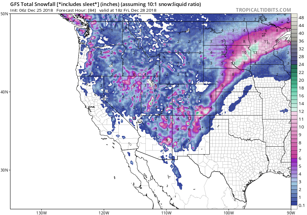
Below: Total snowfall through Friday. Improving conditions in most of Utah, moderate storm for the Pacific Northwest, and decent totals for the San Juans (Tricky chase) and New Mexico (Eastern side is favored).

Where to chase? Ultimately, the Pacific Northwest midweek or a trickier chase in the San Juans will be favorable. The Wasatch continuous with light snow building up nicely this week (I forecasted a weekly total of 9-13 inches on a previous post). Late week attention focuses on the San Juans perhaps New Mexico with very tricky wind patterns for ski areas.
Extended:
A second storm system will move into the 4 corners by late Thursday or early Friday. Additional snow will be falling in the San Juans of Colorado. This might do better for Wolf Creek than the initial storm. The models have low confidence in amounts. It's possible that the eastern side of Taos County (New Mexico) grab significant snow where the ski area sees less. I am not confident due to SE wind directions that are not optimal for most ski areas. I will update on this storm system on my next post.
Happy Holidays everyone! For those that chase to the Sierra, I hope you find some deeper amounts at the summits.
Powderchaser Steve


