Snow totals are coming in as forecasted this morning. Telluride is at 6 inches (Still snowing lightly) and Purgatory is at 4 inches. I mentioned on my post yesterday that the highest amounts may fall east of many ski areas due to an unfavorable wind direction. Additional snow is likely in these areas today (2-4). The Wasatch grabbed 4-5 inches overnight in most areas. One notable winner is Brian Head in southern Utah where 11 inches are being reported. Beaver Mountain in northern Utah was highlighted on our post yesterday had 6 inches last night. I am still waiting on reports from Wolf Creek and Silverton that all received snowfall last night. Silverton opens on Thursday!
Snow will continue in the San Juan Mountains today with an additional 2-4 inches likely for many areas.
In the Tetons, the snow picked up again late Tuesday and will bring a fresh 3-5 inches to those on early chairs for Wednesday. Good turning conditions are being reported at both Targhee and JHMR.
If your chasing powder consider the Wasatch for Thursday (Snowing moderately all morning) where a surprise powder day will sneak up by noon. Solid moisture with very cold air should land 3-6 inches on Thursday morning. Higher amounts are possible in the Cottonwoods.
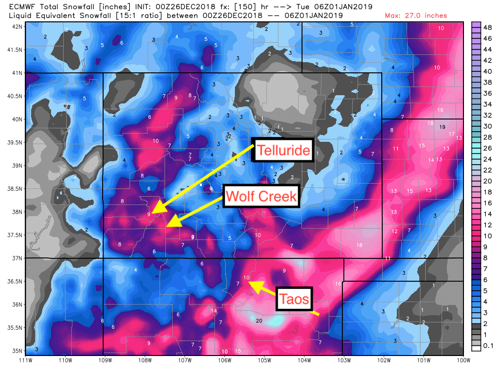
The next 3 days features a 2nd and stronger system for the San Juan Mountains. Moisture will increase over southern Colorado Thursday night/Friday. Heavy snow is possible for Wolf Creek and areas south into New Mexico. Angel Fire/Taos may be good picks for storm skiing Friday. The models are showing 12-15 inches of snowfall for most of central New Mexico extending into the mountains north towards Taos. The only caveat is the wind direction! Winds initially are from the NW (Good for Taos) and the shift to the SE. SE winds are not optimal for heavy snow at most ski areas. This may push moisture east of Taos towards Angel Fire or further towards Raton Pass. Moisture is heavy enough over NM that it's possible that this will make up for the less favorable wind direction. Therefore, I am going with a forecast of 4-9 inches for Taos, 6-10 Angel Fire and higher amounts east of the ski areas. Wind direction may decrease or increase these amounts (My confidence for New Mexico resorts is at 50%). Wolf Creek looks a bit more optimistic. 7-12 inches are likely from Friday AM through Saturday. Best times to ride will be late Friday or early Saturday.
Below: Total snowfall through early next week- Highlights include Wolf Creek and most of north/central New Mexico. The majority of the snow will fall Thursday PM to Saturday AM.

If you're in the Pacific Northwest consider storm skiing Wednesday where 3-6 inches are going to fall before last chair. An additional 2-4 inches is likely tonight so grab some side country gates, or find leftover powder from the previous day. Quality will be very good (Low density). I favor Crystal or Baker for amounts.
Enjoy the powder everyone! Hope you all had a great holiday!
Powderchaser Steve


