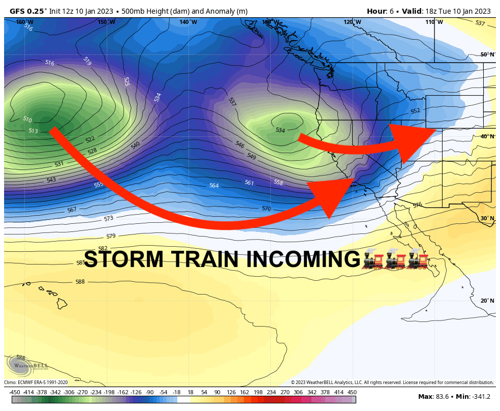
Several storms will impact the western US this week, bringing several more feet of snow to an already legendary snowpack. The best places to chase powder this week will be the Sierra Nevada, Wasatch, and parts of the Rockies.
The first wave of the first storm wrapped up overnight in California. Here are some totals from this storm, which lasted mainly from Sunday night to Tuesday morning:
- Mammoth: 54-70”
- Dodge Ridge: 45”
- Mount Rose: 38-44”
- Sugar Bowl: 29”
- Northstar: 27”
- Palisades Tahoe: 25”
This storm is not done, however. The next surge of moisture has already made it to the mountains and is dropping snow along the entire length of the mountain range. During the ski day on Tuesday, most resorts in west Tahoe (Sugar Bowl, Palisades, Kirkwood) should see 12-18”, with totals closer to 6-10” to the east (Mount Rose, Heavenly). Further south, Mammoth should see at least between 14-20” with a high probability of exceeding that range. All California resorts should have good skiing on Tuesday.
That storm will continue overnight bringing a few more inches to resorts by the time lifts open on Wednesday. We see most resorts in California picking up 2-5” on Tuesday night, with exceptions in the northwest Tahoe basin, with resorts like Sugar Bowl and Palisades looking at 5-10”. Kirkwood will also likely be in this 5-10” range with good snow density (Colder).

From there, it will just be lingering snow showers on Wednesday AM/PM before the end of the storm. Maybe 2-6” total during this period for most resorts.
The storm energy from the first surge already made its way into Utah, dropping some of the following totals at resorts around the region: This snow was accompanied by warm temps and strong winds (Expect creamy to dense snow)
- Sundance: 20”
- Deer Valley: 19”
- Brighton: 18”
- Solitude: 17”
- Snowbird: 15”
- Alta: 14”
- Park City: 13”
- Snowbasin: 13”
- Powder Mountain: 11”
The snow will continue to lightly accumulate during the day, dropping 3-6” during the ski day on Tuesday, with totals on the higher end of this range at Cottonwood resorts (Alta, Snowbird, Brighton, Solitude) and lower totals over the Wasatch crest (Deer Valley, Park City).
A second surge of moisture arrives on Tuesday afternoon, bringing the potential for another great day on Wednesday. The Cottonwood resorts are looking at 8-12” and the PC/DV area is looking at 6-10” overnight, making ski conditions excellent on Wednesday with colder temps. Expect a few more inches to fall during the day on Wednesday - mainly in the morning - but nothing much. A cold front will be associated with this surge, so the snow that falls on top will be nice and light. Just check out the cold front passing through from Tuesday afternoon to Wednesday morning:

Colorado will also be impacted this week. Light precipitation started in Colorado on Monday night, bringing a few inches of fresh snow for the ski day on Tuesday. The biggest winner from last night was Steamboat, who picked up 7”. There will be very little accumulation over the day on Tuesday before another push of storminess occurs on Wednesday night. By Wednesday morning, I-70 resorts will have picked up a dusting, central mountains are looking at 2-5”, and southern mountains are looking at 6-10”. I think the upside is pretty high for these southern resorts, so I wouldn’t be surprised if the San Juans exceed this forecast. Multiply values below by roughly 13 for a rough snowfall forecast, though I do think totals will be a bit higher than this. You can see the higher values are located in the central and northern mountains. Steamboat will be another good chase.

On Thursday morning, precipitation will also begin to push into Oregon and Washington from the southwest, kicking off several straight days of rain in the PNW. Resorts will pick up a few inches on Thursday morning before the precipitation turns to rain in the early afternoon. Snow levels will start at 3,000 feet and will rise to above 6,500 feet by Friday morning. This snow level will likely be higher the further south you go, peaking in Oregon at close to 8,000 feet… yikes. This rain will continue through Saturday afternoon. Below is the total accumulated precipitation by type in the PNW through Sunday from the Canadian model… virtually nowhere will remain unscathed:

Another storm begins in California on Saturday, this one looking even colder and more potent than the last. Specifics remain uncertain, but Monday, Tuesday, and potentially Wednesday look like the best powder-chasing day in the Sierra with good odds for more than a foot each day. Check out the ensemble moisture plume from the GEFS showing another fire hose straight into the Sierra beginning this weekend.

Utah should also score big on that storm, so stay tuned for powder chasing in the Wasatch and potentially the Tetons early next week.
The stormy pattern in the West looks like it'll continue until about the 20th before we shift to a more La Nina-esque pattern with more moisture up north and less frequent storms for California and Utah.
Selkirk Powder Guides (Cat Skiing) in northern Idaho has some open seats for the following dates in January. Please check them for a great backcountry experience outside the summit gates at Schweitzer, and if you book with them mention \"powderchasers\" for a free Concierge promotion (Fee base-level concierge). The dates they have available are below.
Jan. 12 7 seatsJan. 14 8 seatsJan. 17 4 seatsJan. 18 9 seatsJan. 21 6 seats
Announcement:
Powderchasers and our forecast staff are supported by our readership, so if you have not donated, please do so here or join our powder concierge program where we provide 1:1 trip planning for chasing, last-minute custom forecasts, and the best pow day of your life. Support our sponsors and be sure to follow our Instagram and Facebook page @powderchasers.
Happy chasing!


