
SUMMARY- SNORKEL ALERT IN FULL EFFECT FOR THE SIERRA OVER THE NEXT 4 DAYS.
3-6 Feet blasting the Sierra over several days (Ride Powder Saturday-Wednesday). Light to moderate snow is falling in the North Panhandle. Mission Ridge in the East Cascades scored 15 inches of blower. It just started snowing in the Tetons Saturday morning with models showing anywhere from 6-12 inches likely by Sunday. This forecast will focus on the deepest snow for the West. Sometimes too much snow falls in a short period of time, as this could be the case in the Sierra where you can expect many upper mountain closures on Sunday and again perhaps on Monday. The Cascade Range is cold (Mission Ridge would have been a score) with 5-7 inches on the western side of the ranges and up to 15 inches fell on the East (High quality). Oregon may benefit on Saturday with snow dropping south of Washington.
Breaking News: Top reports from Saturday morning (Cold temps and high quality)
1) 49 Degrees North Ski area (North of Spokane)- 18 inches of blower in 24 hours
2) Mission Ridge Ski area (Eastern Cascades of WA- 14 inches
FORECAST:
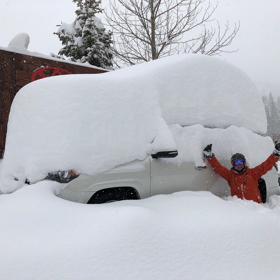
GRAB A SNOSHARK (OUR TOP PICK IN REMOVING SNOW QUICKLY FROM YOUR CAR OR TRUCK) DISCOUNT LINK: https://rebrand.ly/snosharkPC
Snow is falling in the Sierra Saturday morning with 2 inches on the snow telemetry at 8,000 feet current at Squaw. Radar echoes are rather light this morning with action increasing as the day goes on (More below). Epic amounts of snow will fall for most of the entire Sierra Range through Tuesday night.
In the Tetons action is moving in a bit faster than the original forecast with snow currently just starting. The models are in disagreement with the Tetons with several pushing the highest totals (12-15) just north of Jackson into the National Park and further towards Wilson. The American GFS model still shows 12 inches for JHMR and less for Targhee due to wind direction (SW). The Short Term HRRR is confident of 4-8 inches for Saturday (Storm Ski), and a bit more into Sunday (2-5). The Canadian, Euro, and 12KM NAM all show the highest snow just north of the Ski areas so there is some discrepancy in who will see the double digits. Bottom Line: Storm Ski Saturday with temps increasing (32 at the bases), and mid 20's upper mountain. Dense snow will add up by last chair Saturday (4-8) with some additional pow for Sunday (2-4). If the GFS proves correct, amounts may exceed 12 inches by Sunday morning (Sat-Sun pow). Its possible that some rain mixes in near the town of Jackson. Targhee is likely to see less snow but higher quality due to base elevations. JHMR will not be running the Tram this weekend (CV- Precautions).
Below: Snow is beginning to fall over Teton Pass early Saturday morning (Nothing on Telemetry as of 6AM)

Below: The GFS American Model showing storm totals through Sunday at 9-14 inches for the Tetons. The short term HRRR models also are bullish for the Tetons especially Saturday.

Below: The 12KM NAM pushing the highest amounts just north of Jackson towards edges of Teton National Park or further up to Yellowstone.

Below: The least optimistic model showing much less snow for the Ski Areas with even higher amounts in the northern sections of Teton National Park.

The snorkel alert is with very high confidence for the Sierra Range Saturday-Wednesday. Snow is falling over the northern areas of the Sierra Saturday morning. The short term high resolution models show an increase of precipitation by late AM or early PM Saturday with snowfall intensities of 2 inches per hour. This will favor the northern ranges of the lake before shifting south this afternoon. Winds will be strong Saturday with upper mountain locations or wind exposed ridges possibly closed. Expect 4-9 inches by the last chair Saturday (Storm ski the northern Sierra). Areas further south towards Mammoth will see the heaviest snow begin at some point Saturday afternoon or evening. Higher amounts for Mammoth will occur Monday night into Tuesday.
Snow will continue, heavy at times for most of the Sierra Range Saturday night (North is slightly favored) into Sunday. 12-16 additional inches are likely overnight. Temps will will fall bringing a few inches outside Reno to 7-10 inches at lake level. Winds are easing slightly but still strong (50-80 MPH gusts above 8500 feet). It's a gamble on what will spin Sunday due to significant avalanche mitigation, continuing heavy snowfall, and moderate to strong winds. Bottom Line: Good quality, heavy snow, right side up. Winds will increase Avalanche danger and 2 inches per hour snowfall rates Sunday may keep many upper elevation areas buttoned up if patrol can't keep ahead of it (Perhaps consider resorts with lower angle terrain, lower elevations due to winds like Homewood, Northstar, Sierra at Tahoe, or the lower elevations of Heavenly). While the models show higher amounts in the northern Sierra, areas towards Mammoth will do well with somewhat lower totals being reported on Sunday. Mammoth might score higher amounts than the north in the extended especially on Tuesday morning.
Totals along the Sierra Crest by the end of Sunday will range (Storm total) will range from 15-30 inches and still snowing.
Below: Total snowfall per the American Model (GFS) through midnight Monday. Highest amounts favoring the northern Sierra with the southern areas not far behind. Crest totals of 80 inches might be a bit overdone here. Expect wide areas of 30-50 inches above 8500 feet. Peak will be Saturday night into Sunday with heavy snow continuing into Monday. The Southern Sierra may report higher totals Tuesday morning.

EXTENDED:
Snow will continue moderate Sunday night into Monday (Another 8-12 inches likely) for much of the Sierra Range. The trend is to push the highest amounts further south for late Monday into Tuesday with another blast of a double digits likely especially for Mammoth. The northern areas will begin to dig out on Tuesday while it is likely to still be snowing further south. Wednesday might offer a break for the southern Sierra.
Storm totals in the models are ranging from 40-80 inches through Wednesday for the Sierra!
In the Rockies, the models are trending a good chance of decent moisture pushing into Arizona, Utah, New Mexico and a good portion of Colorado midweek. With the flow from the SW it's possible that some high end snow totals get reported in the San Juan Range by Thursday. Some snow is likely to fall in the Wasatch. Higher amounts are possible Colorado late next week as moisture pulls up from the south over much of the State with a hint of West or North winds bringing higher chances of snow along I-70 and the Front Range (Stay tuned).
Below: Low pressure tracks over the 4 corners by Wednesday and into the Front Range of Colorado by Thursday next week.

See you on first chair! WOO HOO- Snorkel Alerts are rare so hopefully it all happens.
Here is your discount code for our top pick for removing snow fast (First chair) from your car- https://rebrand.ly/snosharkPC
Powderchaser Steve


