
Good morning Powder Lovers! The week ahead is going to see a very unsettled pattern with 3 storms, each progressively colder in the west. Currently it is dumping in the Cascades with Mt Baker nabbing 14 inches overnight Saturday. Moisture and colder air is just reaching the I-90 Corridor. Stevens Pass telemetry shows 7-8 inches and snowing as of 5AM Sunday. Snow will pick up from areas south of Mt Baker on Sunday with an additional 6-10 inches favoring the central Cascades (Stevens, Alpental, Stevens). Further south the models put totals near Crystal in the 5-8 inch range (2 noted as of 5AM Sunday). Colder air and snow drag south increasing over White Pass and over the Oregon mountains for a significant event (9-16). Bottom Line PNW: Snow tapers in the northern mountains and spreads south on Sunday favoring the Central Cascades of Washington and areas further south, especially Oregon (Timberline, Mt Hood,Bachelor). Chase from Baker Sunday to areas south for last chair or first chair Monday.
Below: Stevens Pass snowfall as of 5AM Sunday- Expect 12 plus inch storm totals by late Sunday. Snow will pick up during the day especially along I-90 and areas north to Stevens Pass.

Below: Telemetry at Mt Baker showing a healthy overnight dump of 14 inches for Sunday morning. Snow is tapering off in the northern Cascades on Sunday with 2-4 additional likely.

The next 7-9 days is going to be full of action with chases in many directions dependent on base depths, new openings, and obviously snow. We are looking at 5 foot storm totals or more for some mountains in the west, especially the PNW over the next week. Many areas of the Rockies will also be deep.
The PNW storm Sunday drags east favoring the central Idaho Panhandle, Tetons, northern Utah and areas of northern Colorado. It's likely that Teton Pass nab 6-11 inches Sunday night into Monday morning with similar amounts for Targhee and JHMR. Strong winds Sunday night might create some funk (Wind blown areas initially). The Wasatch begins to see snow early Monday morning (2-5 during the day south, 4-8 further north), under SW flow initially. its possible that the northern Wasatch ends up a bit deeper towards Snowbasin (Northern Wasatch) Monday. W-NW flow and colder temps Monday night will favor the areas south of the Great Salt Lake and another 5-11 inches is possible by noon Tuesday, especially in the Cottonwoods (4-8 for Park City). While this is not an overly moist system the ingredients are there for some upside surprises in Utah especially the Cottonwoods on Tuesday. Chase from northern areas Monday to perhaps further south for Tuesday?
Below: University of Utah Ensemble plumes for Snowbasin ski area still show a degree of uncertainty for this storm with an average of around 10 inches by Tuesday. Snow begins over the northern areas a bit sooner so late Monday could be decent.

Below: University of Utah Cottonwood Forecast shows light snow on Monday for Alta increasing late, and into Tuesday. We are calling for 8-14 inch storm totals through Tuesday as this model can be overdone at time relying strictly on the American GFS. Look for some upside surprises on Monday as the storm begins over the northern Wasatch (Snowbasin) under SW flow.

If you want to chase powder in Colorado, snow will be falling from late Monday to Tuesday. Models are showing generally 5-11 inches for the I-70 corridor (Summit etc.) and upside amounts possible for areas just north of Boulder including Eldora, Winter Park, Rabbit Ears Pass, Steamboat, and Rocky Mountain National Park. Not surprised to see 9-15 inches in some of these upside areas, but it's hard to forecast these anomalies with accuracy. The Elks near Aspen are also on my upside list with perhaps Crested Butte scoring decent amounts Monday night. Winds shift to the NW early Tuesday so areas further south towards Telluride and even Wolf Creek will score some freshies (4-8). Snow showers continue on Tuesday under NW flow so resorts along I-70 will continue to reap some additional rewards albeit lighter intensity. Roads will be snow packed along I-70 so be sure you have your winter tires on (Tire Rack is our source for winter tires). Nearly every resort in Colorado will be reporting new snow by Tuesday.
Below: Sunday morning upside surprise at Winter Park with 6 inches on the snow report (Overnight pow). Who's there?

Below: Total snowfall through Tuesday shows a foot or more for the Tetons (Pink in the upper center of image), Wasatch Range of Utah, and areas of north and central Colorado. The mountains north or west of Boulder towards Fort Collins, including Steamboat, RMNP, WP, and even Eldora might land some surprise totals as well as areas further south towards Aspen. We are going with 5-10 inches on average in Colorado with the upside areas in the 10-16 inch range.

The extended forecast will feature a very cold airmass moving into the PNW, with snow levels crashing to 500 feet (Lowland snow is possible). By Tuesday night snow intensity will increase in the Cascades and move over the Rockies. In highlighting any specific areas, we currently see 12-20 inches for the Cascades (Midweek storm), 9-17 inches for widespread areas of Idaho (Brundage, Selkirk Powder Guides, Sun Valley) that trickles south into the Sierra by the weekend. Models show heavy snow possible by Friday or Saturday for the Sierra as this cold airmass moves south and eventually kicks into the Rockies late next week. That might bring another foot or more to many areas of the Rocky Mountain ranges with even higher amounts for Californiaevada. The prevailing winds appear to mainly SW. That system might drag over the southern Rockies at some point.
Below: Confidence is low this far out. Current models below showing 2 day snowfall for the west ending Saturday December 3rd at 4-5PM with a good dump for many areas of the Sierra, Idaho and northern Montana. That storm will have left significant snow for the Cascade range mid next week mentioned above. The 4 corners might benefit late in this period as the low kicks east, but it's too far out to forecast with accuracy.

Below: Storm #1 in the PNW Sunday moving over the north central Rockies Monday/Tuesday this week (Ongoing now).

Below: Storm #2 in the Northwest by midweek (Very cold temps and heavy snowfall) slides south towards the Sierra late- week pumping ample moisture north into Idaho by Thursday.

Below: This storm system will drag further south by the weekend with a decent chance of heavy snow for the Sierra.
Unsettled conditions for the west are likely to continue into the December 4-6 range with a hint of a possible break by December 7th

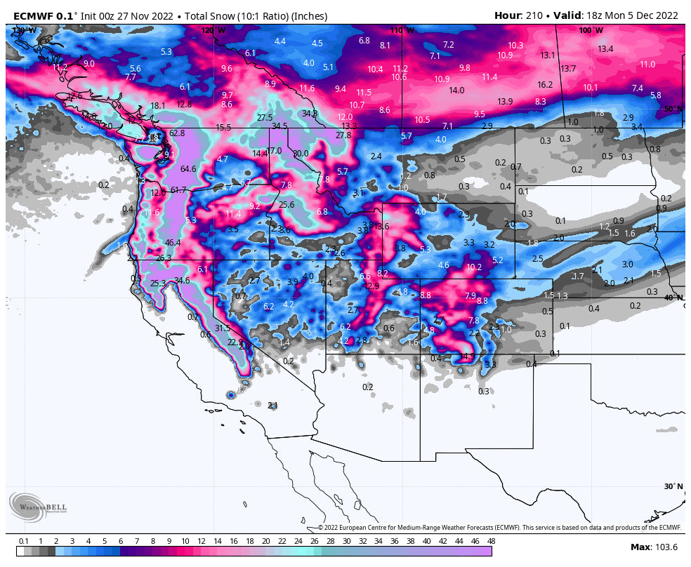
Below: Fantasy map! Looking out 8 days on the European model shows total pow through Monday (8 day period). This will definitely change as we get closer to each system but provides a rough draft of what is likely to come for the west. This is epic for late November, early December.

Announcement: Powderchasers and our forecast staff is supported by our readership, so if you have not donated, please do so here or join our powder concierge program where we provide 1:1 trip planning for chasing, last-minute custom forecasts, and the best pow day of your life. Support our sponsors and be sure to follow our Instagram and Facebook page @powderchasers.
Please follow our instagram and Facebook pages for updates @powderchasers.
You can follow my adventure as a forecaster @powderchasersteve on Instagram for chasing pow, adventure, travel photography.
Enjoy the powder everyone! It's going to be a wild ride over the next 7-9 days.
Powderchaser Steve


