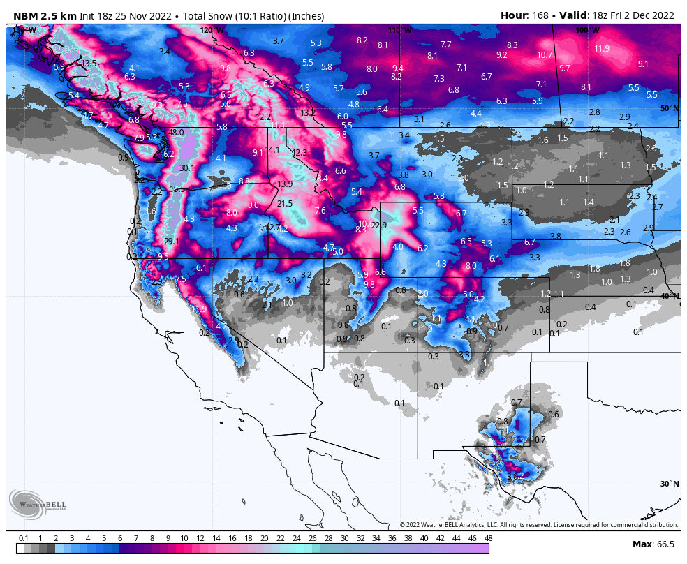
Three storms will affect the Western US this week, bringing significant accumulations to BC, Washington, Oregon, Idaho, Montana, Wyoming, and Colorado. Big snow is possible for California and Utah next week, but specifics remain unknown and confidence remains low at this point with the models in disagreement.
The first surge of moisture reached the Pacific Northwest this morning, bringing light accumulations to the Cascades of Washington and Oregon. After the snow wraps up on Friday night, accumulations at resorts in Washington should be below 5” and at Mt. Hood with only around 2”. The best odds for good snow will be further up north at Mt. Baker. The snow from this storm will be fairly dense initially Friday/Saturday- but snow is snow!
Below: Total snowfall in the Cascades for Friday, with intensity easing in the evening but picking up again late Saturday with some intense snowfall rates into Sunday with much colder temps.

Announcement: Please donate here or support PC by joining the Powder Concierge (Custom forecasting for your deepest chases of the season). This supports your frequent pow casts and keeps our doors open.
Storm #2
The second storm arrives on Saturday night, with showers starting in the northern Cascade mountains and creeping south. Precipitation will peak overnight between Saturday and Sunday, so look out for deep snow on Sunday morning. Showers linger throughout the day on Sunday, so resorts will be receiving free refills all day. Sunday should be a great day of skiing in the Cascades! Precipitation will stick around on Monday into Tuesday morning.
In terms of chase targets for open areas for this storm, the best prospects are Mt. Baker and Crystal Mountain and Oregon resorts (Higher base depths) all looking good for 20-30” by Tuesday morning. SW flow late this weekend and early next week will benefit the northern and central Cascades for even higher amounts. Cold Convergenze zones may set up over Stevens Pass and the I-90 resorts (Alpental), bringing upside totals as well. Canada also scores nicely with this storm with an excess of a foot for western BC, and 8-12 inches further east in interior sections.
The Oregon Cascades including Bachelor and Mt Hood are going to grab 20-30 inches through Tuesday morning with great snow quality (Many have decent base depths).
Interior areas of the Cascades including Mission Ridge grab light to moderate amounts Sunday/Monday with moderate amounts Tuesday/Wednesday when temps drop and moisture increases. Selkirk Powder Guides near Schweitzer will do well especially Sunday/Monday (8-14).
For any backcountry skiers, Paradise is looking good for 30-40” and could be absolutely excellent all next week.
Below: There are no losers in the Cascades with 2-3 feet likely for many western areas of the PNW, with most of the action starting Saturday night and continuing through late Tuesday. Another storm may come in Wednesday.

In Idaho and Montana, the best chase target looks to be Selkirk Powder and Schweitzer, which looks good for 15+ inches by Tuesday morning. Most of this precipitation falls on Sunday morning, so Sunday could be an awesome day for skiing there. By Tuesday morning, Sun Valley should see 2-5” and Big Sky & Bridger Bowl should both expect between 6 and 10 inches.
For Wyoming (Targhee, Teton Pass, JHMR) this storm has shown consistency for 12-15 inches by late Monday and cold temps.z Winds are strong initially Sunday night in the Tetons (Could be deep windblown pockets). Models have shown over an inch of moisture between this period. We favor Wyoming a bit on snowfall totals through Monday versus areas to the south. Snow ratios will be high and quality high aside from the strong winds Sunday night.
This wave of snow begins in the Northern mountains of Colorado and Utah on Monday afternoon. Tuesday and Wednesday will both be great days for skiing, with the Wasatch looking at 10-14” Summit County Colorado resorts are shaping up for 4-8” by Wednesday morning with Steamboat and the Aspen area mountains (Elks) seeing higher amounts (8-14). The I-70 corridor is likely going to be in the 5-10 inch range. The winds will be out of the west-northwest, which can be absolutely great for Steamboat. Watch for surprise totals there by late Tuesday in a few areas, likely north of I-70.
The third storm will begin in the Pacific Northwest sometime on Tuesday night/Wednesday morning. The specifics remain very uncertain – so I won’t get into exact totals much – but what we do know is that this storm will come in much colder than the first two and could bring some really great conditions to the Pacific Northwest. Snow in Seattle is looking increasingly likely next week.
This storm will also bring at least some snow to California on Thursday, but the models are split on how much snow this system will actually bring. The European ensemble is showing 3+ inches of liquid precipitation in Tahoe while the American system is showing less than 1”. The Canadian is somewhere between the two, with roughly 2”. If the storm digs south and hits California, Utah will also be poised to the deep goods. We’ll have to see how things shake out with the disagreement of the models. Stay tuned for another Powderchasers forecast with updates for this system.
The good news is that we have good confidence that temperatures in the entire Western US will remain below average through at least the first week of December (See below).


