Summary
The southern mountains of Utah, Colorado, and all-mountain ranges of Arizona continue to grab freshies. The Sierra gets walloped Wednesday to Friday. More storms for the weekend and extended.
Announcement: Remember, its storms like this that if chasing powder we highly endorse snow tires. Check out our partnership with Tire Rack for your simplest total wheel/tire solutions here.
Forecast:
Snow continues to fall in the 4 corners with snow telemetry for Wolf Creek showing 7-9 inches since 5 PM Sunday. Purgatory is reporting 9 inches in 24 hours, and Telluride has seen 10 inches in the past 3 days. Some of the largest snow totals will come from Arizona Snowbowl (Snowing heavily on Monday) where 24 inches have fallen in the past 2 days. There is even snow in the forecast for Tucson Arizona today! I would be storm skiing in Arizona today and grabbing moderate amounts for Tuesday morning (7-15 additional from Monday AM to Tuesday).
Heavy snow from Arizona will push leftovers, slightly weakening up to southern Utah and Colorado Monday to Tuesday (PM Monday or early Tuesday should be the best days to ride). This will be generally a 5-10 inch event especially for Brian Head, Wolf Creek, and perhaps Purgatory. The amounts look less than some of the previous events, so many areas will approach or fall short of double digits. Aim to ride late Monday or early Tuesday.
The decaying leftovers edge north and east over the eastern plains of Colorado for Monday night and Tuesday. Models yesterday were a bit more optimistic for Summit County, however current runs look less. It's likey that the eastern sections of the Divide, perhaps Loveland, Winter Park, or Eldora sneak out 1-4 inches by Tuesday morning. Areas further west towards Summit are wildcards with only a few inches. Let's hope we wake up Tuesday to more, but my optimism is low. The eastern plains of Colorado might see higher amounts. Boo Hoo.
The headlines this week are going to be over the Sierra. Squaw telemetry is showing 7 inches of blower fell at 8000 feet last night (16 degrees) and approximately 5-6 inches at the base (Good riding for Monday on the groomers). The Ski patrol snow study plot at Mammoth appears to be near 5 inches at the summit (Unofficial report).
A strong low-pressure system takes direct aim on the Sierra Range Wednesday to Friday. Remnants push north into Oregon and Washington, especially on Wednesday. Moderate snow will be found in these areas especially interior Washington (East Cascades) which is likely to score some moderate pow during this period. Crystal and areas south may also reap some light or moderate amounts. Further south in Oregon it's likely that Mount Ashland scores a deeper surprise than its northern counterparts.
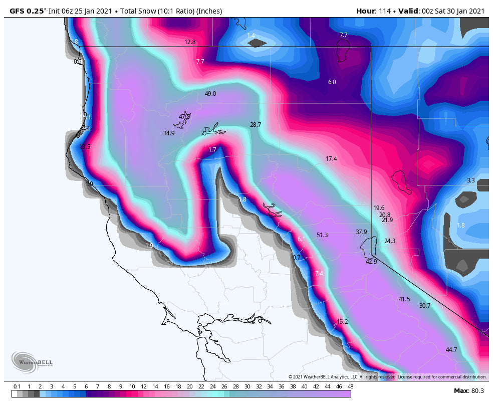
Bottom Line: 4-5 feet with high confidence for the Sierra Crest Wednesday to Friday (North and south). Higher amounts are possible! Additional snow moves in late this weekend into early next week. Caveats: Strong winds with ridge gusts near 90-110 MPH will create lift closures, high avalanche conditions, and perhaps even full mountain closures in some areas. Perhaps stick to lower elevation resorts? You might not be riding your favorite chair until Friday, Saturday, or even Sunday. Road closures are for certain on I-80 at times. For chasing powder sometimes you need to bypass the deepest snow. Storms like this can be your best run or your most frustrating 3 days.
Below: Total snowfall for the Sierra through Friday. Higher amounts are possible!

In the long-range wrung out moisture from the Sierra pushes east over the Rockies Thursday to Saturday. This is likely to set off a stream of steady light or moderate snow for the Tetons late week, edging a bit into northern Utah and eventually Colorado by the weekend. The sum totals in some areas might be decent, however, it's unlikely that any 24 periods exceed 4-8 inches. This system should favor the northern Rockies.
Enjoy the powder everyone!
Powderchaser Steve


