
Powder Discussion:
A low-pressure system off the PNW Coast with cold air will move inland early next week, merging with a more significant low in the Sierra. These systems converge over the Rockies. Snowfall will be evident in nearly every region of the West. There are several waves of energy from Monday to Thursday in the West, with some short breaks possible. The timing of these breaks or the short-lived easing of the winds presents a challenging forecast.
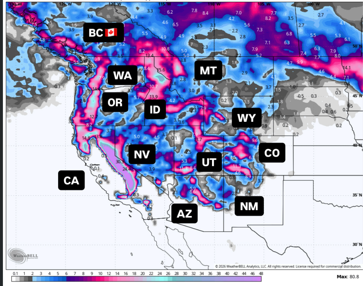
Below: 3 Low-pressure systems entering the west next week.

The highest snow totals will land in the Sierra, where we will measure snow in 4-6 feet by Wednesday. This storm will bring strong winds to the Sierra, Rockies, and Four Corners. Less wind is noted in the northern Rockies, perhaps from the Tetons into Montana and the PNW. Chasing powder with this storm will be tricky, dodging winds, avalanche closures, and road impacts. You might not want to chase the deepest totals.
Chasing this storm will take precision with timing of avoiding the windiest periods, or simply sticking to lower elevation resorts, especially the Sierra. The Rockies won't be immune to the winds either, so timing is key to this chase. Even the Four Corners ramp up extreme S or SW winds initially. Northern areas of the Rockies (Wyoming to the PNW) will see lower winds.
Northern areas of the Rockies, PNW, and Idaho are expected to see less wind as the northern low advances into this region (Less wind and moderate snow).
Sponsor Alert Jackson Hole Airport: Did you know that the Jackson Hole Airport teamed up with Start transit to offer hourly bus service from the town of Jackson to and from the airport! Please support this transit system that is affordable and green (Avoid parking at the airport). Details on this service are here.
Expected storm totals through Thursday morning.
Sierra Range: 45-65 inches
Oregon Cascades: 9-14 inches
Northern Idaho (Schweitzer): 14 inches
Sun Valley: 10-16 inches
Tetons: 10-14 inches
Wasatch Range: 20-35 inches
Big Sky: 5-10 inches
Arizona Snowbowl: 9-14 inches
Lee Canyon (Vegas): 10-19 inches
Crested Butte: 12-20 inches
Aspen: 9-16 inches
Vail: 6-11 inches
Wolf Creek: 15-25 inches.
Sunday night to Monday
Below: The early chase for Monday lands 5-8 inches for the northern Sierra, lighter totals in the PNW, and moderate totals noted in northern Idaho (Schwietzer and perhaps northern Montana GNP). Storm skiing then ensues on Monday as pow slides south over the Sierra Range, boosting these numbers by last chair. The PNW also fills in somewhat on Monday. The Wasatch, central and southern Idaho, and the Tetons fill in towards the latter portion of this loop by late Monday night (Idaho) into Tuesday morning (WY/UT, AZ).

Below: Upper level winds at 10K (Sustained) Monday morning to Tuesday afternoon. Strong S winds early Monday are confined to the southern Sierra with a period of increasing wind mid Monday into Tuesday (pushes north towards Lake Tahoe). You can see a swath of strong winds move into Oregon on Tuesday. The entire Sierra Range is impacted by these winds by early PM Monday-Tuesday.
In the Rockies, Extreme winds are noted (Sustained 40s, 50s) on Tuesday in the Wasatch that push into the Tetons. Extreme winds are also noted in the Four Corners (AZ, etc.) on Tuesday. There might be a few breaks at times (Hard to nail down lift closure timing). Quality will be impacted on windward slopes (S, SW). Tuesday will keep many areas buttoned up.

Tuesday to Thursday- Cold front and snowfall, possible decrease in winds?
Below: 10K foot temps "Cold Front" approaches the Sierra by Monday evening (Density will decrease to blower) and hits Idaho by early Tuesday. The Tetons and Wasatch grab the colder air on Wednesday. Colorado grabs the cold air from Wednesday afternoon to Thursday. This cold front will bring the highest quality powder. Winds might decrease a bit with a South or SW flow turning a bit more westerly behind the cold front.

Below: The European model shows snow continuing in the Sierra on Tuesday as another more substantial surge of moisture moves, greatly increasing totals here and over the Rockies, peaking Tuesday night or Wednesday. S, SW flow will bring high snow totals initially to southern Utah, northern Arizona, the Vegas mountains, and south-central Colorado. Colorado will score midday Wednesday to Thursday (Higher totals during this time).
Moisture pushes into the Wasatch late Tuesday night into Wednesday with colder air and a wind shift to the West or WNW (Precip rates ramp up). The Tetons, while on the northern end of this system, should be able to eke out 7-14 inches (Models are not all in agreement). In Colorado higher odds of 12-25 inches in the southern and central regions, 10-16 inches just south of I-70 (Aspen), and 7-12 inches along I-70 that peaks late Wednesday to Thursday. The Sierra will end up with around 5-6 feet by Wednesday.

Below: University of Utah plumes for Snowbasin showing 25-plus inches (Does well with S, SW flow). The GFS (Blue) is more bullish. Colder temps on Wednesday will push totals possibly higher.

Below: Park City Summit will be deep with this storm peaking Tuesday/Wednesday (20 inches) and going up further beyond midweek.

Below: Jackson Hole Plumes show a steady ramp up early to mid next week in the 15-inch range. The chart gets higher mid to late next week. Models have struggled with totals, with a few on the 2-foot side, and others less pushing moisture north or south of the Tetons. No outstanding 12-hour period, but a slow ramp-up.
Sponsor Alert: High Mountain Heli in the Tetons has a few open seats during the holiday week. The Tetons have filled in well in the past 7 days. Blower Pow due next week might be prime to book a seat. Mention Powderchasers and get a free concierge package.

Below: Kirkwood plumes top out around 60 inches (M-W) in a relatively short period by Wednesday.

Below: Totals through Thursday for UT/WY/CO from the European model.

Bottom Line: Not a perfect storm with a lot that can go wrong (Wind or too much snow in 48 hours). However, when the terrain opens, there will be no bottom. It's a deep storm that has you rolling the dice. I hope you hit the Jackpot. Thursday or Friday might offer the best odds of open terrain and less wind in the deepest areas of the forecast.
In the extended, a very potent storm is showing up on the models for the PNW towards the end of next week into the following week. That storm has snow god potential. Northern or central Rockies might also get deep.
Forecaster: Powderchaser Steve @powderchasersteve (Instagram)
HELP US OUT- Please support your love of powder and our free forecasts with a donation here, or join our concierge program. We have merch on the website.
We appreciate the support for these free forecasts.


