A series of storms will roll through the west this week, bringing FEET of snow to the mountains. This storm cycle may end up being the biggest one of the season so far. Virtually every mountain range will do well with this storm cycle.
The first storm is currently barreling into California’s Sierra Nevada mountains. This storm came in warm and wet. Snow levels in the Tahoe region were as high as 10,000 feet, bringing significant rain to every resort in the region. Fortunately, rain switched to snow overnight and the snow level in the Northern Sierra is currently 6,500 feet as of 11am and dropping. This is snow level derived from the fall velocity of the particles (rain falls faster than snow, so at a certain threshold, we're pretty certain that the particle is a rain droplet rather than a snowflake). Blue/green indicates slower fall velocity (snow) and red/purple indicates faster fall velocity (rain):

Resorts in Tahoe are reporting a few inches of wet, heavy snow with the highest totals reported at Mt. Rose (12”) and Heavenly (14”). Their high elevation allowed the precipitation to switch from rain to snow earlier last night, so they picked up a few extra inches.
The first wave of storm energy from this same system moved into Utah and Colorado last night, as well. Resorts in Utah did not perform as well as expected, with most resorts in the Wasatch picking up 5-10”. The one exception to this was Sundance, which reported 18” this morning. In Colorado, most resorts picked up 3-8” with the highest totals at Steamboat, Winter Park, and Crested Butte.
The snow will continue to hammer the Sierra throughout the day today. By the time the lifts close today, I’m expecting 15-25” of snow to fall at resorts around Tahoe and Mammoth, likely on the higher end of that range. Precipitation in Tahoe will continue overnight and be virtually done by Sunday morning. Further south in Mammoth, snow will linger slightly longer into the early afternoon. Overnight on Sunday, I anticipate resorts picking up another 10-20”. The best chase target in Tahoe might be Mt. Rose, where I anticipate its higher elevation to keep temperatures at mid-mountain cold enough to keep snow to liquid ratios above 10:1. Not high quality snow by any means, but it certainly beats the 7-8:1 slush that will fall at lower elevations. Mammoth will also do well with their higher elevation, although they will receive less moisture and thus less snowfall.
Notice the warm lower atmosphere temperatures below at 10K on Saturday morning. That is the summits of many resorts. This will keep snow heavy and wet in California, Utah, and Colorado with this system:- Colder air is aimed at the Rockies late Sunday to Monday. 
In Utah, resorts in the canyons should pick up 10-15” throughout the ski day, with 5-10” totals found in Park City and Deer Valley. The snow will be fairly dense, but still nice skiing on top of a few inches last night. The faucet will turn on in Utah on Saturday night, where I see 20-30” for the canyon resorts and 10-20” for PC/DV by Sunday morning. Temperatures will prevent the snow from being super fluffy, so the higher you can go on Sunday, the better. Sunday morning will start off windy with the potential for wind holds, but I think skiing higher-elevation powder on Sunday be worth it as winds die down throughout the day.d Snow totals will vary widely from multiple feet above 8,000 feet to just 5-10 inches at 6500. Check out the HRRR snowfall forecast through Sunday morning: the 24 inches is noted near the Cottonwoods. Temps will stay warm through Sunday early afternoon. 
In Colorado, expect anywhere from trace to 3” during the ski day today, with lower totals found in the I-70 region. Saturday night into Sunday morning won’t bring anything particularly chase-worthy, with only a few extra inches to the resorts.
Snow will continue in Utah and Colorado on Sunday. During the ski day on Sunday, expect 5-10” in the Cottonwoods, 3-8” at PC/DV, and an inch or two in Colorado. Precipitation will then start to die down in Utah on Sunday night but will still dump another 10-20” in the Cottonwoods and 5-10” at PC/DV. On Monday, resorts may pick up a few extra inches, but nothing huge.
Meanwhile, a second surge of moisture hits the Rockies on Sunday night. By Monday morning, conditions could be pretty good in Colorado. Wolf Creek will be the chase target on Monday morning, with over a foot looking likely and an inch or two throughout the day on Monday. Other resorts will pick up far less: Aspen area ~3” overnight with 2” throught the day, I-70 resorts 1-3” with 1-3” throughout the day, and Steamboat with about 2” overnight and 4-8” throughout the day.
The next storm begins in California on Monday morning with the first flakes beginning to fall in the early afternoon. Resorts may pick up a dusting on Monday afternoon. By Tuesday morning, most resorts in the Tahoe region will be looking at 3-5\".
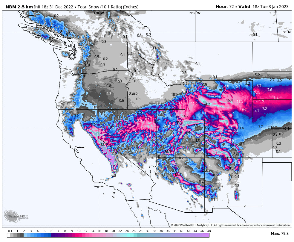
Below is the NBM snowfall forecast through Tuesday. Notice how everything north of California, Utah, and Colorado misses out. This is due to the zonal (straight east-west) jet flow delivering moisture straight to the south:
Beyond this, we’re starting to get into the range where specifics become less and less reliable, but I’ll walk through the pattern for the next 10 days.
Residual moisture from the Tuesday storm will hit Utah and Colorado on Wednesday, but accumulations from this will be fairly minimal, maybe a dusting in Northern Utah and a few inches in Colorado.
The next storm begins in California - again - on Wednesday morning. Fortunately, this storm is looking cold and will bring snow in the mountains from start to finish. This storm could drop 2-3 feet on Tahoe and Mammoth between Wednesday night and Friday. This moisture will go on to impact Utah and Colorado, as well bringing maybe a foot to Utah and 4-10” to Colorado.
The models agree on another cold storm impacting California starting on Saturday, but the magnitude remains uncertain. Beyond this, all the models continue to have moisture hitting California into the foreseeable future. It’s going to be a good start to 2023 for California!
Announcement!
Powderchasers and our forecast staff are supported by our readership, so if you have not donated, please do so here or join our powder concierge program where we provide 1:1 trip planning for chasing, last-minute custom forecasts, and the best pow day of your life. Support our sponsors and be sure to follow our Instagram and Facebook page @powderchasers.
Please contact us at powderchasers1@gmail.com if you are interested in becoming a sponsor for the website and forecasts. Please support our current sponsors!
Enjoy the snow, and stay safe! AVY danger will rise significantly with this moisture laden storm. Please Please don't go into the backcountry unless you have advanced skills or simply stay out until things settle down.
Powderchasers.com


