
It was a very active period and a classic Sierra Dump with bonus cold temperatures and low winds on Thursday morning has some epic storm totals. Snow is already moving into the Rockies for some healthy totals going into Friday.
Here are some unofficial totals from Telemetry in the Sierra as of 4 AM Thursday.
Palisades: 18 inches
Truckee: 10 inches
Kirkwood: 18 inches
Heavenly: 13 inches
Sierra Snow Lab: 27 inches
Mt. Rose (Base): 12 inches
Mammoth: 22 inches
Sugarbowl: 18 inches
Below: Sugar Bowl Resort as of 4 AM is deep (see the table on the lower left) and still dumping.

Below: Short-term HRRR models showing another 12 inches Thursday morning south of Lake Tahoe (Dodge Ridge and Bear Valley to Mammoth possibly favored) and 3-7 additional inches along or north of the Lake.
Bottom Line: This is nearly a perfect storm with strong winds on Wednesday decreasing overnight into Thursday with high-quality powder.
The northern areas of the Lake bump up towards the end of this loop Thursday night into Friday as another system impacts them. Overall, the first wave storm totals by the end of the day Thursday will be in the 20-30 inch range as forecasted, with some higher totals possibly in the south.

Below: Map: 12-hour snowfall ending Friday PM. This represents total additional snowfall on Friday from 9 AM to 9 PM (Another 9-15 inches along the Crest with 5-10 at lake level). Friday will be a repeat powder day.

Honorable Mention: Snow overspread the Cascades of Washington and Oregon on Wednesday night, bringing 8 inches to Crystal and Mt. Hood Meadows. Snow is underway in Idaho on Thursday morning, with many resorts near McCall in the 3-7 inch range per webcams.
Below: Sun Valley snuck in some decent totals Wednesday night with southerly flow and moisture from the Sierra bringing them 8 inches.

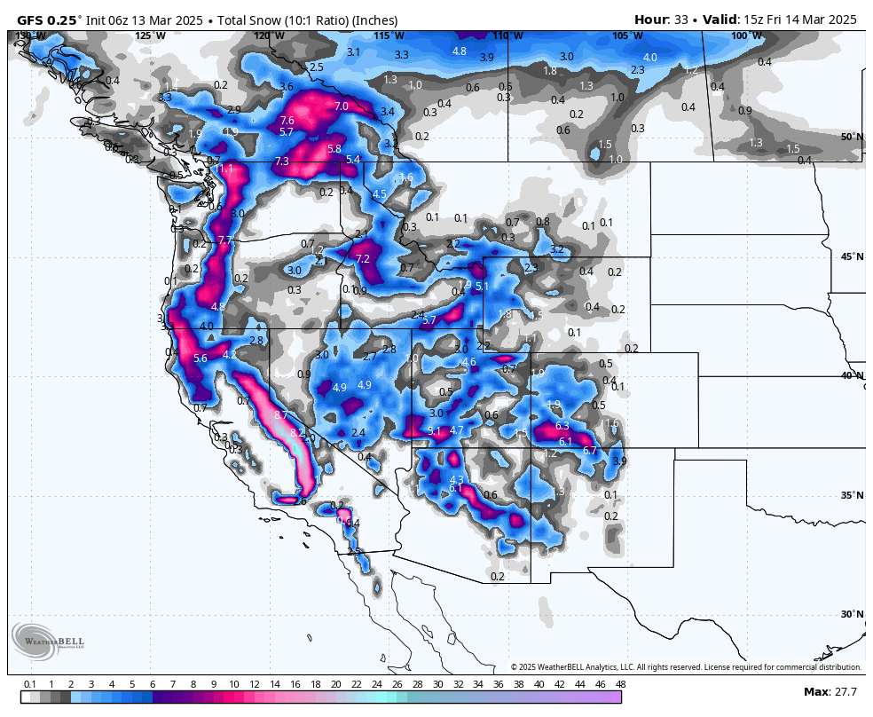
Below: Snow totals filling in from Thursday morning to Friday night. The highlighted areas are in interior BC, PNW, western Idaho, Tetons, and Wasatch, with higher totals possible in the Four Corners states.

Timing & Chases: You can storm ski in Idaho on Thursday and move east into Utah by 7 AM, Wyoming, and the Four Corners for fresh snow on Friday morning. Hit the deeper snow in the Sierra both Thursday morning and Friday with some deep storm skiing (plus the option of new openings Friday/Saturday in the Sierra).
Snow works further north in Colorado early Friday morning, so resorts on I-70, including Aspen, Vail, Summit County, and even Steamboat, will benefit during Friday morning (Strom skiing).
Resorts favored by NW flow will help here (Vail Pass, Copper, Breckenridge, Steamboat).
Deepest Chases Thursday/Friday: Sierra, Southern Utah, Northern Utah (Cottonwoods), Southern Colorado, Northern Arizona, PNW wildcards, Tetons.
Wildcard chase Friday by 4 PM: NW flow kicks in along I-70 and might bring some surprise totals to areas like Vail Pass and Snowmass, perhaps north to Steamboat, or east to Summit County.
Expected totals by Friday mid-morning:
Sierra: 2-3 feet (discussed above and ongoing now)
Western Idaho: 5-10 inches
Tetons: 6-12 inches (Targhee favored later Thursday to Friday with NW flow)
Wasatch Range (Northern Utah including I-80, Ogden, and Provo): 6-12 inches (12-18 in the Cottonwoods).
Brian Head: 12-15 inches
Arizona Snowbowl: 9-12 inches
Wolf Creek: 9-11 inches
Telluride: 7-15 inches
Aspen: 5-10
Steamboat: 5-10
Vail: 7-12
Crested Butte: 5-10
Breckenridge: 5-10
Beaver Creek: 5-10
Purgatory: 5-11
Below: Short-term NAM and the HRR are much more bullish than the deterministic GFS, especially for the Cottonwoods by Friday morning. This map shows some enhanced snow bands setting very close to the Cottonwoods, Park City (Canyons side), or just south. If it lands just south, amounts will be lower, and even Sundance could come up ahead (it usually does best with S flow vs. the incoming NW flow). I have highlighted a few regions for Friday chases.
Notes: On Thursday, SW flow and denser snow with strong winds are noted, along with NW flow, lighter densities, and less wind Thursday night into Friday (two phases of the storm).

Extended POW
Below: The Map shows 24-hour previous snowfall increments from Saturday night to Tuesday afternoon on March 18th. You can see the influence in the PNW, Sierra, Idaho, Montana, Tetons, Wasatch, and Colorado.

Below: 3-day total snowfall ending Tuesday evening, March 18th. It is safe to say that many areas of the West will be deep late this weekend into early next week! You have many options for chasing powder here. Unfortunately, the Canadian resorts are too far north, and the southern San Juan range or AZ and NM appear too far south.

Announcement: Our Powder Concierge program allows you to add a guarantee for deep powder, or the chase is on us! We are running a promo for only $5 for the powder insurance (Normally $19.99) that guarantees you powder.
HELP US OUT! We are a small tribe of powder junkies working part time for you!
NOTE: Please support Powderchasers with a donation, merchandise purchase(such as a hat or stickers), or sign up for our custom Concierge Powder Forecast Package, where we provide 1:1 phone & email support to get you to the deepest locations possible. When chasing snow, the Concierge gets you the very best intel. Sign up for our free email list so you never miss a powder day. We are also seeking new sponsors and ambassadors who want to submit photos and videos; please reach out for more information.
Forecaster: Powderchaser Steve @powderchasersteve


