
1. SUMMARY
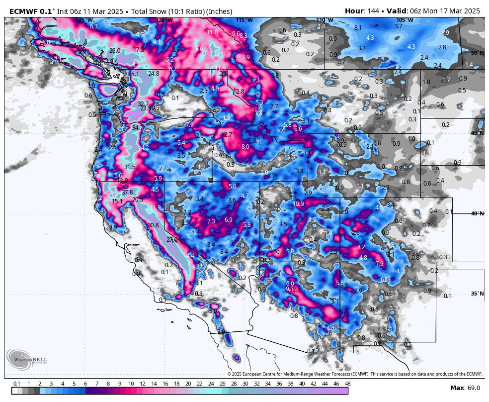
A massive winter storm takes aim at the Sierra midweek, delivering 1–2+ feet of snow with moderately high Snow-Liquid Ratios (SLRs). The Pacific Northwest, Utah, the Northern Rockies, and Colorado all see waves of snowfall, but the biggest prize is in California on Thursday. After that, the Intermountain West picks up decent totals heading into the weekend. Bottom line: Chase the Sierra on Thursday, then look to Utah and parts of Colorado Friday into Saturday.
NOTE: Please support Powderchasers with a donation, merchandise purchase(such as a hat or stickers), or sign up for our custom Concierge Powder Forecast Package, where we provide 1:1 phone & email support to get you to the deepest locations possible. When chasing snow, the Concierge gets you the very best intel. Sign up for our free email list so you never miss a powder day. We are also seeking new sponsors and ambassadors who want to submit photos and videos; please reach out for more information.
2. CHASE FORECAST
Wednesday (3/12)

- California (Sierra): Snow starts to ramp up late in the day. Expect only light accumulations by Wednesday afternoon—better to hold out for Thursday’s bigger dump.
- Pacific Northwest: Ongoing moderate snow adds up to a few fresh inches in the Cascades. Not a knockout day, but it’ll soften surfaces at Stevens, Crystal, and Timberline.
- Utah & Colorado: Mostly warm/dry or minimal new snow during the day. Storm arrives later.
- Northern Rockies: Light to moderate snow in Idaho/Montana pass areas, but amounts aren’t huge yet.
Overall, Wednesday is more of a teaser day, with the big show still ahead.
Thursday (3/13)

- Sierra (California): This is the main event. From Wednesday night into Thursday afternoon, resorts like Mammoth and Kirkwood could stack up 17–25 inches of fresh, with SLRs around 12–16. That’s deep, surfy powder—epic territory! Strong ridgetop winds will be a factor, but expect faceshots if you find wind-sheltered zones.
- Pacific Northwest: Continued moderate snow, especially overnight Wednesday into Thursday. Totals of 4–8 inches in places like Mt. Bachelor and Timberline. Worth chasing if you’re local, but overshadowed by the Sierra’s big dump.
- Utah: Snow ramps up late Thursday, so daytime accumulations remain modest (a few inches possible up high).
- Colorado: Pre-storm day—snow intensifies overnight into Friday. Not a big Thursday chase.
- Northern Rockies: Light to moderate accumulations, primarily in Idaho’s higher spots (like Brundage) and southwestern Montana.
Chase pick: Sierra for possibly 1–2+ feet of moderate-to-high SLR fluff by Thursday’s last chair.
Friday (3/14)

- Utah: Thursday night plus Friday day combines for around 6–10 inches in places like Alta/Snowbird, with SLRs pushing 13–16—nice, fluffy powder. Watch out for gusty winds in exposed terrain.
- Southwestern Colorado: Wolf Creek and Telluride benefit from a well-timed shot Thursday night into Friday, totaling 7–11+ inches. SLRs are exceptionally high (14–18), so you’ll be floating on top.
- Northern & Central Colorado (Vail, Loveland, etc.): More moderate but still respectable Friday morning refresh—could be 4–6 inches in many spots with good quality.
- California (Sierra): Additional snow but on the lighter side (a few new inches), so still decent leftover conditions from Thursday’s dump.
- PNW & Northern Rockies: The pattern continues with smaller pulses, 3–6 inch type refreshes in spots. Solid day if you’re local, but not quite the big game.
Chase pick: Little Cottonwood Canyon (Utah) or southwestern Colorado for lighter-density fresh.
Saturday (3/15)

- Utah: Another wave pushes through Friday night into Saturday, adding 4–8 inches around the Cottonwoods again. Cold temps keep snow preserved, so conditions remain prime.
- Colorado: Lingering snow for areas like Telluride and Wolf Creek, but likely in the modest range of a few additional inches.
- California (Sierra): Mostly leftover scraps. Not a big new-snow day, but Friday’s and any overnight dusting could still serve up soft turns.
- PNW & Northern Rockies: On-and-off snow showers continue but generally in smaller increments (2–5 inches). Watch for areas with minimal wind to find fresh pockets.
3. KEY POINTS
-
Good:
- California sees the biggest single-storm totals this week with moderate-to-high SLR.
- Utah/Colorado get multiple days of quality powder thanks to cold temps, particularly Friday into Saturday.
- Snow preservation remains solid in many areas as colder air spills in behind each storm.
-
Bad:
- Winds could be fierce along Sierra ridges (gusts topping 60+ mph on Wednesday afternoon/evening/night) and breezy in parts of the PNW and Colorado. Strong winds affect snow quality (denser).
- Some lower-elevation bases briefly see rain or mixed precipitation before snow levels drop.
- Potential road closures and travel issues in heavy storm periods, especially in the Sierra.
-
Wildcards:
- Timing differences between consecutive waves, especially Sunday into early next week.
- Lake-effect or terrain-enhanced bursts in the Northern Rockies and around the Great Salt Lake—some micro bullseyes could pop unexpectedly.
- Confidence is moderate in multi-day totals; slight model discrepancies linger around exact storm tracks.
4. REGION-BY-REGION DETAILS
California (Sierra)
 A potent midweek storm slams in from the Pacific with intense moisture. Snow levels start around 4500–6000 feet Wednesday morning but drop fast (3k–4k feet in the northern Sierra, ~4.5k in Tahoe by sunset). Heaviest snowfall hits Wednesday afternoon/evening through Thursday, delivering 1–2+ feet above 6k or 7k feet. Expect strong southwest ridge-top winds on Wednesday afternoon/evening/night (gusts 60–70 mph) before shifting westerly. Farther south, Mammoth can see up to 2 feet on upper mountain by Thursday night, with SLRs improving as colder air rushes in. Another system Friday adds smaller refreshes, then Sunday night into Monday likely brings one more round. Temperatures remain below normal into next week, so the snow should stay preserved. Kirkwood, Palisades Tahoe, Mammoth, and Sugar Bowl look like prime winners.
Pacific Northwest
 A series of disturbances roll through mid to late week, keeping the Cascades and Oregon volcanoes in a cycle of moderate snowfall. Expect 2–6" increments most days, occasionally pushing 6–10" in favored spots like Mt. Bachelor, Timberline, or near Stevens Pass. Snow levels generally lower from ~4000–5500 feet midweek to 1500–3000 feet by Friday, which helps keep surface conditions wintry. Winds in the passes can gust 30–40 mph, with brief lulls between systems. Another stronger system arrives this weekend, especially for Washington’s northern Cascades. Overall, it’s a nice continuous refresh, but not the same massive single-dump scenario as the Sierra.
Utah
 Thursday’s incoming system cranks up in the evening, with snow levels near 6000+ feet initially but quickly crashing below 4000 feet overnight. By Friday morning, the upper Cottonwoods (Alta/Snowbird, Solitude/Brighton) may see 6–10 inches of fairly high-SLR fluff, especially if winds don’t scour the open terrain. A second wave hits Friday night into Saturday, adding another 4–8 inches for many Wasatch resorts, with even lower snow levels (down to 3000 feet or so). Winds remain gusty but not extreme. Southern Utah (Brian Head, Eagle Point) sees healthy accumulations, though a bit warmer at the onset. Overall, multiple pulses keep conditions fresh from Friday onward.
Northern Rockies (ID/MT/WY)
 A broad parade of systems keeps snow in the forecast almost daily, but each wave looks moderate in strength, resulting in 3–8" type daily totals at many resorts. Montana’s Big Sky and Whitefish, Idaho’s Brundage and Sun Valley, and Wyoming’s Jackson/Targhee all get periodic refreshes. Snow levels can bounce between valley floors and 5k feet, but overall, cooler air helps preserve what falls. Wind can be gusty in some passes, and localized heavier bursts (like near the Continental Divide or the ID/MT border) are possible. Keep an eye out for heavier pockets around Saturday–Sunday as a wetter system arrives.
Colorado
 A solid storm arrives late Thursday, bringing a round of widespread snow Friday. Southwestern mountains (Wolf Creek, Telluride) see the biggest Friday totals, 7–11+ inches with impressively high SLR. Central and northern resorts (Vail, Steamboat, Aspen Snowmass) also pick up moderate snow (4–8 inches in many areas) by Friday morning, continuing lightly into Saturday. Winds are a concern, especially east of the Divide, but the deeper mountain zones will see less infiltration of warm air, leading to fluffier accumulations. By Sunday, snowfall is tapering off, though southwestern corners could squeak out a bit more. Expect below-normal temps to keep everything fresh.
5. EXTENDED OUTLOOK
A broad trough remains locked over much of the West, feeding additional storms into next week. Expect continued cold temperatures and periods of snow for the mountains in California, the Intermountain West, and parts of the Pacific Northwest. Confidence is moderate that another potent system could line up for mid- to late next week—so keep the snorkel on standby if this active pattern keeps rolling!
Announcement: Our Powder Concierge program allows for you to add a guarantee for deep order or the chase is on us! We are running a promo for only $5 for the powder insurance (Normally $19.99).
HELP US OUT! We are a small tribe of powder junkies working part time for you!
NOTE: Please support Powderchasers with a donation, merchandise purchase(such as a hat or stickers), or sign up for our custom Concierge Powder Forecast Package, where we provide 1:1 phone & email support to get you to the deepest locations possible. When chasing snow, the Concierge gets you the very best intel. Sign up for our free email list so you never miss a powder day. We are also seeking new sponsors and ambassadors who want to submit photos and videos; please reach out for more information.


