We are approaching the end of our frequent forecasts and encourage all of you to please donate on our website or purchase the swag. The donations help us more so if you have taken advantage of chasing powder, or living vicariously through Powderchasers please contribute here. We survive on your help from the powder community. Donate: https://powderchasers.com/pages/donate-to-powderchasers
Swag is available here https://powderchasers.com/collections/frontpage
Forecast
There are 2 low pressure systems Powderchasers is watching in the west. The first one will bring wind and very high snow levels to the Sierra Friday/Saturday, followed by a cooler surge of moisture Saturday night to Sunday (Light to moderate snow). Some lake level snow is possible Sunday morning.
Another low pressure system moves in from Canada later this weekend into mid next week that brings hope of some moderate or higher snow totals in the Rockies. That system will be cold and bring decent density powder to the west.
Sierra - Storm #1 this weekend.
Rain at lower and even mid elevations Friday afternoon. Snow will be falling above 8-9,000 feet. Strong winds will impact upper lifts and slowly decrease from Saturday to Sunday. Peak snowfall appears to be from Saturday afternoon to Sunday as the atmosphere is cooling, however, the cold air only drives the snow levels down to the bases on the tail end of the storm (Some minor road impacts are possible later Saturday evening). Low pressure drops south with some snowfall expected for Mt Baldy and the southern CA ranges. Snow totals will likely not exceed 5-10 inches at upper elevations
Bottom Line CA: Upper elevation snowfall from Friday to Sunday. Strong winds on Friday will likely keep upper elevations with the rain/snow line closed. Winds appear to be a bit more southerly vs SW similar to some earlier storms this season that kept most of the snowfall further west of many ski areas. Snow levels above 8,000 feet initially dropping to nearly 6,000 feet on the tail end of the storm could land some fun surf at the peaks this weekend followed by a coating of drier density snow. Aim to ride later Saturday or early Sunday.
Rockies, Canada, PNW
Another low-pressure system with a decent cold front will move down from Canada and impact many areas of the West by early or mid next week.
Below: The southern low weakens and rapidly moves east bringing some light snow to the Wasatch and areas of Colorado early next week. The northern low on this map swings south impacting Alberta and many areas of the northern Rockies next week (Monday to Wednesday).

Below: A decent cold front moves into Canada, PNW, and much of the Rockies early to mid-next week. Snowfall will accompany this front bringing an end to the spring/summer-like conditions we see this week.

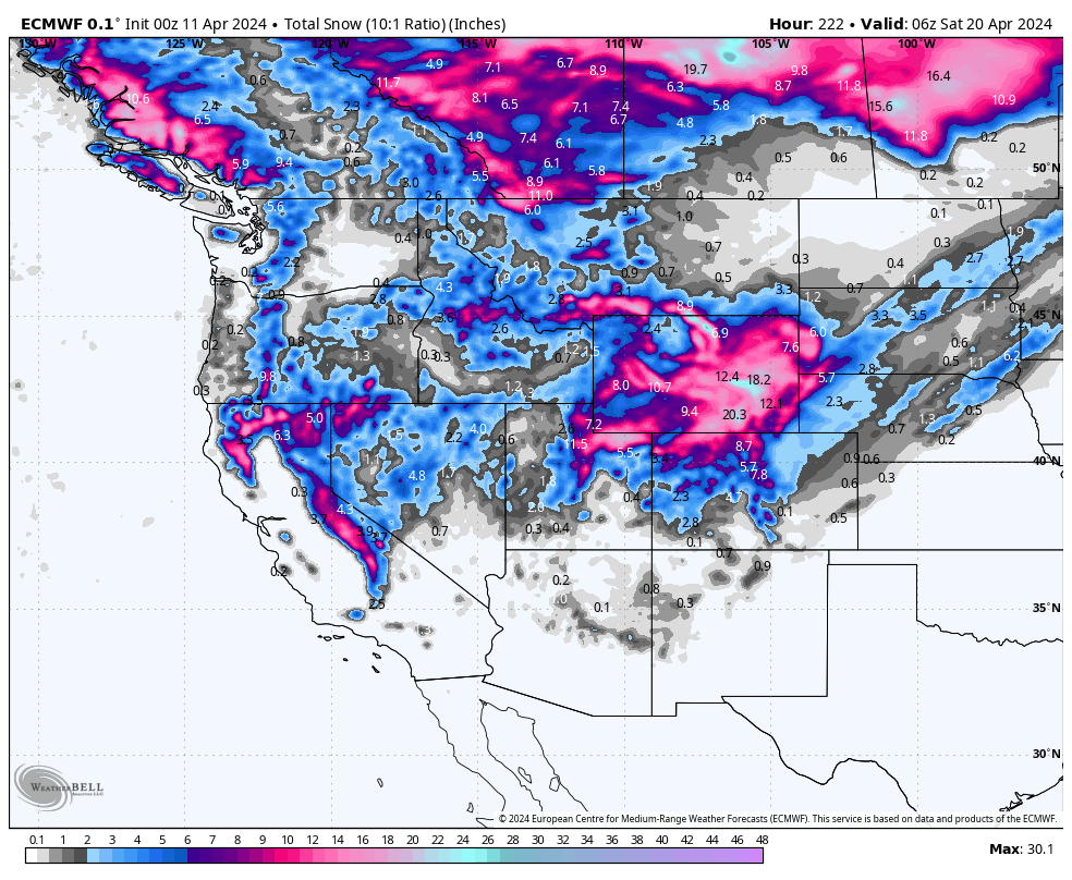
Below: European models showing some decent totals are possible for southern Montana near the Wyoming borders and extending into both Utah and areas of northern Colorado. This storm is too far out to predict with accuracy. Earlier models showed decent odds for southern Montana with less hope in Utah. The latest models push better totals into the Wasatch.
Bottom Line
* Colder temps return to the west next week
* Snow returns to areas of Canada (Interior BC and Alberta) and the Rockies early to mid-next week.
* PNW scores some light or moderate snow. Rockies have the potential of higher totals focussed on Montana, Wyoming, Utah, and Colorado.
* Storm track TBD as we get closer.
* Keep your snow tires on.

Announcement: Alaska has been going off in the past several days with fantastic flying conditions expected next week (Clear early to midweek with more snow possible late week). There are 2 open seats next week with our Heli Sponsor "Alaska Backcountry Guides" that we might be able to discount. Mention Powderchasers for an exclusive e discount and a free custom concierge package from PC next season. Feel free to email PC as well.
HELP US OUT! Please donate here to Powderchasers if you have taken advantage of our free forecasts. This is our number one source of revenue. Free swag for you on all donations from $50 and up. $100 donations grab you a custom shirt also!
We have new Powderchasers shirts fresh off production for sale currently for just $32 (Front and back powder)


Powderchaser Steve @powderchasersteve on Instagram


