We are approaching the end of our frequent forecasts and encourage all of you to please donate on our website or purchase the swag. The donations help us more so if you have taken advantage of chasing powder, or living vicariously through Powderchasers please contribute here. We survive on your help from the powder community. Donate: https://powderchasers.com/pages/donate-to-powderchasers
Swag is available here with a special discount on all shirts using discount code "spring" https://powderchasers.com/collections/frontpage
Forecast
Good morning everyone. Summer like temps have infiltrated the west in the past several days. A weak cold front will overspread Utah and Colorado Monday/Tuesday and kick off a taste of winter for some dense pow skiing for both Monday (Storm ski) and Tuesday. Storm ski on Monday for the Wasatch Range above 8,000 feet and chase the storm to Colorado for Tuesday morning pow. A separate system will bring lighter density pow to Montana for Wednesday.
Below: Low pressure over the Central Rockies (Wasatch to northern Colorado) early this week. Low #2 is coming in from Canada with colder air and will stay north primarily impacting interior Canada and Montana before ejecting east (Midweek storm).

Temps will be in the mid 40's at at mid mountain in the Cottonwoods Sunday and fall into the mid to upper 20's on Monday morning. With this storm being reasonably warm it is possible that the dense snow that falls Monday in Utah does a good job at covering the slush bumps from the past several days (In April we can't be picky). By midday Monday or early Tuesday conditions might actually ski pretty well above 8,000 feet.
At this time of year, we would prefer a slow cooling trend as opposed to a fast crash of temps with a noisy bottom. Moisture continues in Utah into Monday evening under NW flow (lighter intensity). Amounts from Monday to late Monday night should be in the 9-15 inch range for the Cottonwoods. Most of the moisture will focus on Salt Lake County and south into central Utah. Areas north or along I-80 will see much lower totals (PCMR, Ogden area).
Colorado scores powder Monday evening to Tuesday morning. Models have consistently favored resorts closest to the Divide along I-70 or north (WP, RMNP, Eldora). We like the wind direction on Monday night from the NW which leads us to believe resorts further west including Breckenridge, Vail Pass and even some of the Aspen area mountains end up doing well.
Colorado totals could exceed 10-16 inches for areas along or north of I-70 and 6-12 inches just south into Summit County. The corridor towards Copper or Vail show lower moisture totals, however NW winds in our opinion could sneak out some surprises (5-11) with orographic lift (Cooling over the mountain ranges).
Low #2
Meanwhile, by Tuesday night and Wednesday a sharp cold front will bring medium to low density powder to most of Montana favoring the Gallatin Range (Big Sky) and extending east towards Red Lodge Mountain. Amounts in these areas could easily reach 12 inches by Wednesday midday. The cold air stays north into both Wyoming and Montana. Snow density will be high quality in these areas. The Tetons are on the southern fringe of the action and should only grab light or moderate totals.
Areas of Canada including Revelstoke and extending east into Alberta will also see decent quality moderate snowfall from this system.
Below: Total snowfall through Wednesday on the European model showing heaviest totals for northern Colorado, Central Wasatch Range (Cottonwoods) and southern Montana. Utah and Colorado score Monday/Tuesday with Montana scoring with the cold front due later Tuesday/Wednesday.

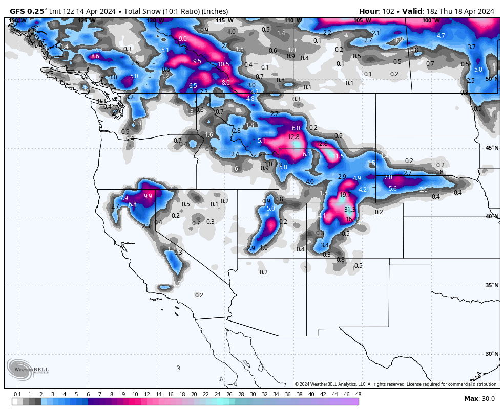
Below: The American GFS shows slightly lower totals in northern Utah with up to 25-30 inches for some mountain ranges near the Divide in Colorado (We think this might be overdone). The GFS is also very bullish for Montana resorts in the southern regions near Bozeman extending to Red Lodge. The shorter term NAM is less bullish.

Below: Cold front focussed on the northern ranges of the Rockies midweek and extending briefly into the Tetons before retreating north. This cold front likely will not impact the central Rockies (Utah and Colorado) and keep snowfall going for Montana midweek.

Chases: You might be able to chase from Utah to Colorado Monday-Tuesday and then up to Montana for Wednesday.
4 days left to purchase your IKON PASS at a discount here
Announcement - discounts on our new shirts
HELP US OUT! Please donate here to Powderchasers if you have taken advantage of our free forecasts. This is our number one source of revenue. Free swag for you on all donations from $50 and up. $100 donations grab you a custom shirt also!
SPRING DISCOUNT ON ALL PC SHIRTS NOW.
We have new Powderchasers shirts fresh off production for sale currently for just $32 (Front and back powder). USE DISCOUNT CODE "spring" TO RECEIVE A 10% DISCOUNT ON ALL SHIRTS THIS WEEK.


Below: My Sunday was pure bliss in Moab with mid 70's and clear skies on Amasa Back at 8AM.

Forecaster: Powderchaser Steve @powderchasersteve on Instagram


