Good morning everyone
This is a quick recap of snow totals for the west where an unusually cold April storm is continuing to bear down on the PNW especially in Oregon. Montana scored 30 inches in 12 hours at Red Lodge Mountain.
Red Lodge Mountain: 30 Inches
Snowmass: 17 inches
Vail: 10 inches (Fell in just a 3 hour period Tuesday morning)
Mt Bachelor: 23 inches in 72 hours.
Alta: 11-15 inches in 48 hours.
Please check out the latest early season renewal and purchase options above for the IKON pass (22/23 season).
Announcement: Powderchasers is looking for new sponsors and has very affordable advertising slots for the 22/23 season. Please reach out to us if you are interested in becoming a sponsor. We reach a substantial amount of snow riders on social media and our powder alerts. We are also looking for snow forecasters if you are interested in working with us. Contact: @powderchasersmedia@gmail.com.
Conditions on Tuesday were reported as epic at Vail (7-9 inches in 3 hour with empty slopes), amazing at Red Lodge Mountain (30 inches), and deep spots in the Cottonwoods with some wind impacted areas (Gusts were in the 60's) and crust layers followed by deep snow in other spots. The reports from Oregon are fantastic. Some areas will be opening up new terrain Wednesday and look for that to continue into the week, especially in Oregon.
In looking at the next best places to chase powder, snow continues for the Oregon Cascades through Thursday morning (8-12). The Rockies grab leftovers on Thursday and Friday (2 periods of 3-6 for the Tetons and Wasatch). Conditions in the Rockies could improve with these storms with Colorado on the tail end of the moisture feed. Oregon will end up with 4-5 foot storm totals. Montana scored Tuesday with some new openings set for Wednesday. It has been a great 48 hours.
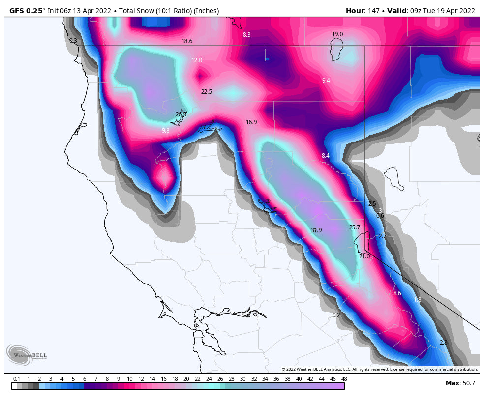
The Sierra will get deep by the weekend with a storm Thursday and again on Saturday. Totals will exceed 8-12 inches combined with both systems. Summits may ski very well with very little snow at the bases. This is split between 2 different stormy periods this week.
Below: Total snowfall for the Sierra through early next week. Most of this snow will occur Thursday and Saturday with 2 modest storms.

The extended forecast continues a trend for low pressure through April 22nd. Additional systems will move ashore over the PNW and stretch south over the Sierra and east into the Rockies.
Below: Total snowfall for the west through Sunday. The Sierra is highlighted with some decent totals followed by the PNW and a few teasers for the Wasatch and Tetons (Modest amounts).

Below: Current storm impacting the PNW and Sierra. You can see a 2nd system moving into the Sierra at the tail end of this map for the weekend (Saturday). Map period-Wednesday to Saturday this week.

Below: Another low pressure system moves ashore early next week (Monday for the Cascades and perhaps Sierra.

Below: Another low pressure system noted on the ensembles for late next week for the west.

High pressure might take hold after the April 22nd period but models this far out are subject to changes.
Follow my Instagram feed @powderchasersteve for the latest in travel adventure, photography, and powder.
You can donate to Powderchasers here if you have followed our forecasts for the season.
Enjoy the powder everyone.


