Another tease for Utah with 2-4 inches likely during Thursday before an increase of heavier snow hits the San Juan Mountains. If your in the Cascades, a convergence zone of cold NW flow brought a quick 4-7 inches to the Crystal Mountain since the upper lifts closed. The chases late this week will include the San Juan mountains of Colorado and New Mexico with a caveat that the highest totals will be found east of the ski areas. The extended looks very active for the Northwest and BC.
FORECAST:
Utah scored 3-8 inches Tuesday night and Wednesday on top of the 2-5 inches previously. Conditions were top notch according to some of my trustworthy friends that were skiing the Cottonwoods. Park City has also seen a continual reset of light snowfall over the past week.
The next storm system is just approaching the Wasatch with light snow showers overspreading most of southern Idaho. This will drop into the north/central mountains of Utah this morning and quickly pass by the time the lifts close on Thursday. Expect a quick hit of 2-4 inches today of super low-density feathers. That system moves over the 4 corners region late Thursday night into Friday.
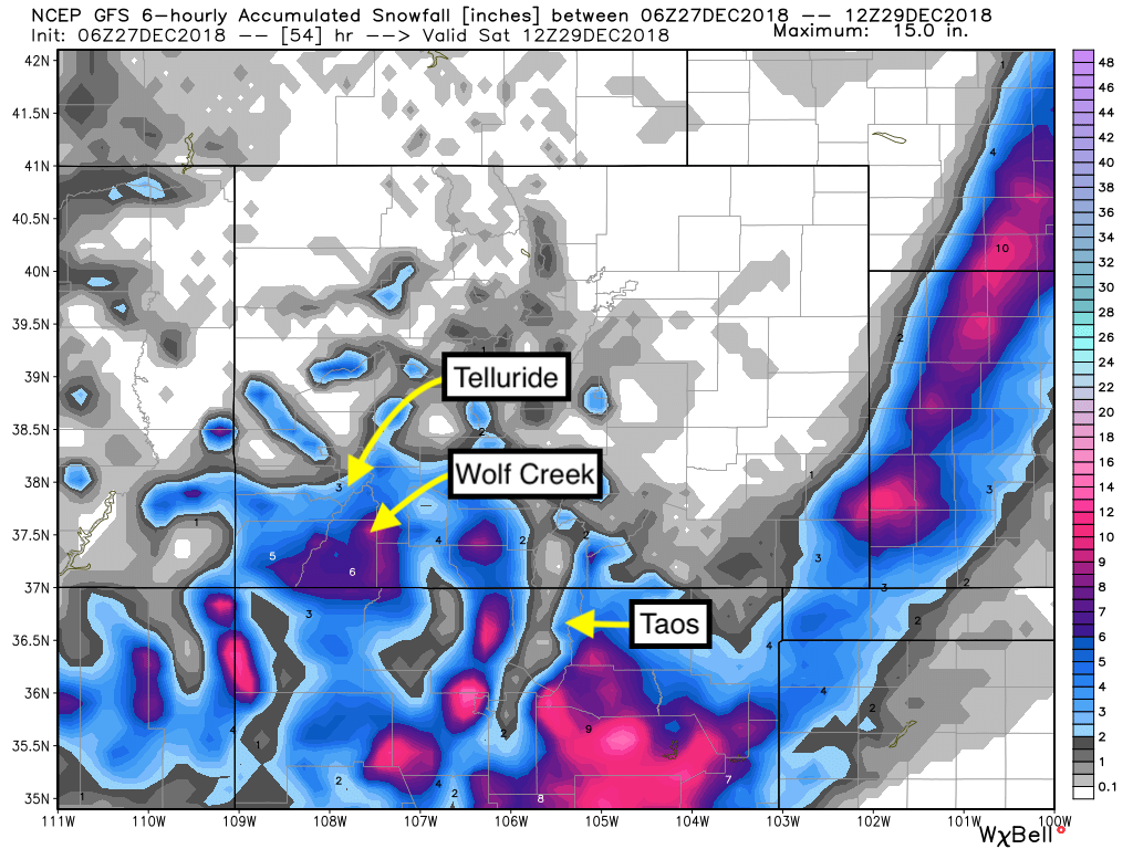
The models are not spectacular on moisture, however, the snow ratios are at 20:1 or greater due to very cold temps that will blast most of Colorado and New Mexico in the next few days. Moisture totals for Wolf Creek are around.06 inches, so that could equivalate to 12 inches of snow (At 32 degrees that would have correlated to 6 inches). NWS has winter storm warnings up for most of southern Colorado including the Durango area. I am most confident with mountains south and east. That might include Purgatory (A bit of a stretch) and with higher confidence Wolf Creek (moderate to perhaps heavy) Some light snow is also possible for Monarch (light) Telluride (Light or moderate) is likely to see lighter amounts but will grab some powder during Friday. Timing and wind directions are making this forecast tricky. SE winds are evident for the bulk of the storm that often skunk some of the ski areas. Timing: Some light snow Thursday night turns moderate by Friday openings. Snow continues Friday with 4-6 inches likely by closing at Wolf Creek (Purgatory wildcard). Light snow will be falling in most of central Colorado including Monarch Pass and areas north of Telluride.
Snow continues in Colorado Friday night bringing an additional 2-4 inches to Wolf Creek Pass and lighter amounts west and north. If we are lucky higher amounts could be possible bringing our storm totals over double digits (It might be a stretch). Best times to ride powder will be late Friday morning through Saturday.
New Mexico is on tap to grab 1-2 feet of freshies! Unfortunately, the 2-foot totals will be east of most ski areas. Snow will begin on Friday and ramp up PM into Saturday. My conservative forecast puts 4-9 inches for these areas with the caveat of higher amounts into Saturday. Wind shifts to the NW at the tail end of the storm that may help Taos. I'm going conservative with my totals purely from storm totals favoring the eastern plains. The Good: I am often off on my forecasts for NM so let's hope we see higher amounts.
Below: Total snowfall through Saturday morning at 10:1 ratio. 20:1 will double these totals. Wolf Creek Pass may see the highest amounts with greater totals on the east side versus the west (Ski area is a solid wildcard). Taos is a solid wildcard. Telluride airport is the 3 inches on the map (Remember that amount will be higher due to higher snow ratios).

EXTENDED
The extended forecast looks wet! Warmer air will filter into the Northwest this weekend with moderate snowfall at higher elevations. Snow levels rise to 5,000 feet in the south and 4500 feet in the north. Colder air will be in place over interior BC bringing all snow to many areas (Moderate dump). Rain in the southern Cascades (bases), will turn to all snow by Sunday morning with a temperature drop. Sunday may deliver decent quality freshies on top of denser snow from Saturday. Late Saturday or early Sunday may be worth a chase depending on temps.
Moisture from the NW swings over the Rockies Sunday night or Monday. Light to moderate snowfall is likely for most of the Rocky Mountains early next week (Tetons, Wasatch, Colorado, MT).
Additional heavier storms are likely for the Pacific Northwest towards the middle of next week. These will be colder and could deliver heavy snow for most of coastal BC, and the PNW.
Enjoy the powder everyone! Powderchaser Steve


