Summary:
One storm is currently departing the Rockies with high pressure noted in the short term. The long-term models have been consistent for a return to storminess and hopefully decent snowfall for the west and east. Both New England and many resorts in the west could start February with decent powder.
Forecast:
A welcome storm for the Rockies is now departing that left as much as 9 inches of powder for some areas in Colorado. This past system dropped in from Canada grazing over Montana (6 inches at Bridger Bowl) and bringing similar amounts to the Tetons for Friday morning. Conditions in the Tetons were very good Friday with a medium density cushion of fluff that skied well (Smooth to no bottom surface) and even provided some face shots on steeper aspects. If the temps were any colder you would have been feeling bottom so the low 20's was the perfect recipe. Monarch in Colorado came up with the win at 9 inches and Ski Cooper near Leadville was not far behind.
In Utah, numbers were consistent with around 3 inches at most resorts. In the past week, interior BC came in with 12-15 inches of snow so if you were willing to deal with the Covid controls it was a decent place to be in the past several days. My chase took me to Grand Targhee for Friday morning where conditions were very good with medium density fluff and just enough moisture content for that cushion.
Below: 1st chair line up at Grand Targhee on Friday morning (6 inches overnight). Photo: @powderchasersteve via Instagram

Below: Monarch Mountain Webcam on Saturday morning (9 inches in 24 hours).

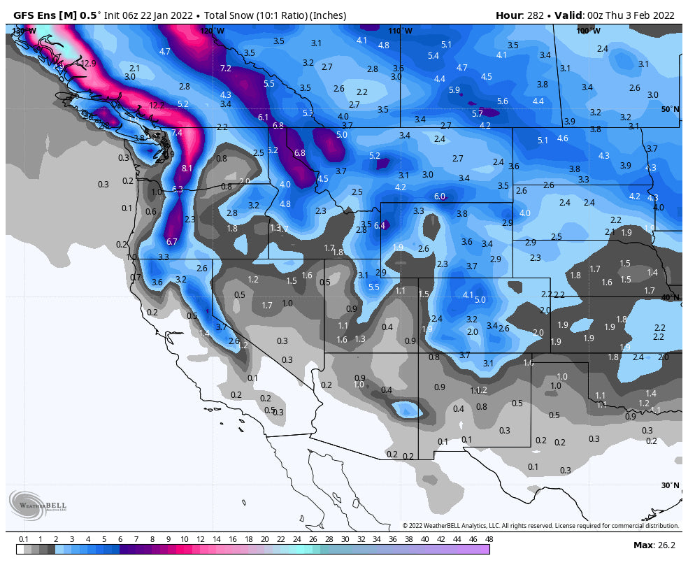
The week ahead will feature very light snow showers to filter over the Rockies by midweek taking an easterly track over central Montana, Wyoming, and Colorado by Wednesday. There are no major storms noted on the models until perhaps the end of the month when a deeper low will usher in cooler temps and a good chance of a decent dump for many areas in the January 31-February 2 timeframe. This storm may bring double digits to some areas of the PNW, Sierra, and Rockies. The central and northern ranges of the BC coast will see very high snowfall totals. The exact timing and track are still in question, with decent odds of good snowfall for the PNW and perhaps the Sierra (Wildcard). The Ensembles show higher amounts for the Pacific Northwest while the operational models show a decent dump for the Sierra ranges. The northern and central ranges of the Rockies are likely to score at some point during the February 1-3 timeframe.
New England is also going to see a storm towards the end of January with colder temps and double digits. A few storms are showing up on the models, so early February skiing could be very good in New England.
Below: Midweek snow showers for northern and central Rockies (Boohoo).

Below: Frigid temps noted in Canada and Montana for the February 2nd timeframe, with a cold front moving into much of the west by late January and early Feb.

Below: Low Pressure approaching New England January 29th. This could be a decent storm. Another storm should follow.

Below: Low-Pressure approaching the Pacific Northwest January 31st.

Below: Low pressure advancing into the Sierra and Rockies into the first days of February.

Below: Ensembles (Averages of multiple model runs) show decent snowfall for many areas of the west on this next storm. The operational models show higher amounts. This far out confidence and accuracy are lacking. Current confidence is high on a stormy period for the end of January, February 1-2, and low to medium confidence of double digits in many areas. Low confidence on who sees the highest totals this far out. If it digs further south the Sierra will do well. North coastal BC may score very high numbers in BC!

Please follow our Instagram and Facebook pages. If you want custom forecasting, chases, or see where we are headed please join the Concierge program for your best odds of ending up in the deep. If you simply want to support Powderchasers please donate or send us a message if you are interested in becoming a sponsor.
If you are interested in Heli and Cat Skiing in Northern Idaho, Selkirk Powder is opening for the season at the end of January-early February for both. There is also a good chance of some decent snowfall for them during this period. They are an excellent operation.
Enjoy the powder everyone! @powderchasersteve via Instagram.


