With only light snow falling in parts of the western US over the last 72 hours, skiing and riding has been pretty normal for January standards. There are still some powder stashes to be found at many areas but you'll have to go searching for them. The deepest powder in the last 3 days has been found on the east coast where areas from North Carolina to Vermont have seen some great snow for their standards!
If you want to chase powder to the best locations and need custom information not found in our posts join our Concierge program. Or simply donate to Powderchasers if you simply like reading our forecasts. We are a small group of forecasters and snow efficianados so any help is greatly appreciated.

Some areas near Beech and Sugar mountains in North Carolina got upwards of a foot of snow. similar totals near Snowshoe in West Virginia as well. Killington in Vermont and areas near there also got some good snows from the last storm. The east coast has dried out this week but they are already watching for another storm to possibly impact them coming up.
Back to the West. As I mentioned, skiing and riding has still been very nice across the west regardless of the recent lackluster pattern. Thanks to the heavy storms that blasted the west at the end of 2021, snowpack is still very healthy.


Comparing snowpack from earlier this month to now, it's not much different but the numbers are lessening. Essentially, this healthy snowpack is leading to good conditions on mountain regardless any lack of fresh snow.
Getting to the forecast, there are no signals for large storms in the near term but there is forecast to be a nice refresh for the Rockies between now and the weekend so if you're planning on getting out this weekend, you'll have some freshies to play on. Overall, the pattern is not conducive for widespread snow so several areas will be missing out on this refresh. Meanwhile, the east coast is looking wetter and colder than normal so any followers from the east coast, there is some good news coming your way. Here's a look at the pattern we're tracking between now and the middle of next week.

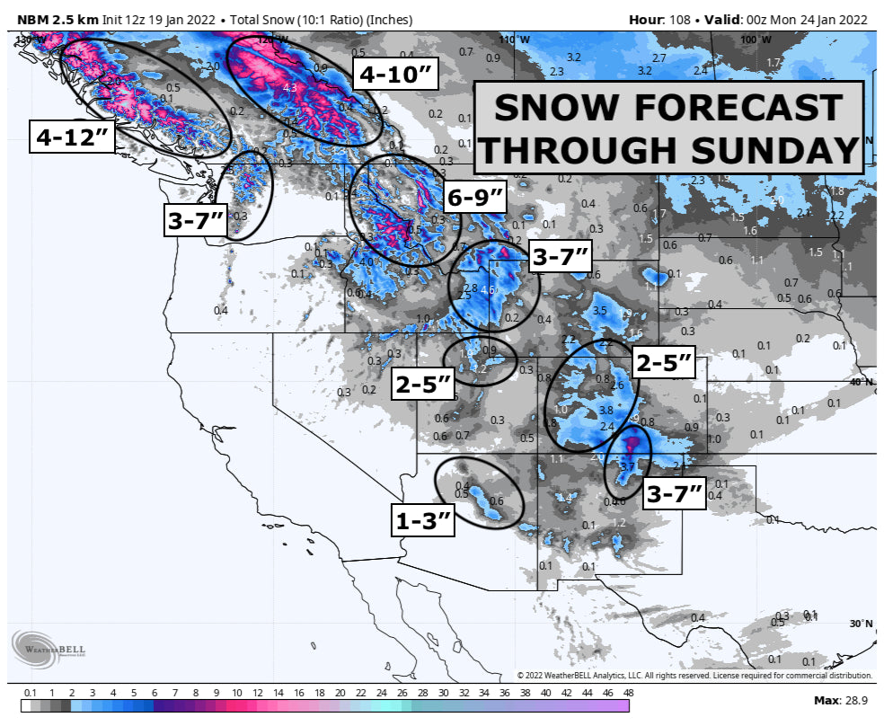
A shortwave will roll down the Rockies today through Thursday bringing snow to areas from Montana and Idaho down to Colorado and Utah by this weekend. This will miss the Sierra Nevada and Oregon Cascades mostly but another storm next week could prove to be more beneficial for them. For the setup the remainder of this week, the colder air will be on the east side of the Rockies so that's where the better snow quality will be found as well. Parts of Idaho and Utah will be on the warmer side of this incoming storm so slightly creamier snow will fall in those areas. This could be true for the western side of Colorado as well. Montana, Wyoming and the Continental Divide ski areas of Colorado should see some great powder snow from this incoming storm.
Here's a look at expected snow totals through Sunday. Most of this will fall before Saturday morning though so this week will prove to have some nice snow to explore.

The only locations missing out from this upcoming storm are the Oregon Cascades and the Sierra in California.
British Columbia
Light to moderate snow will continue through Thursday in BC. Revelstoke and Whistler have a solid chance of getting a half foot of snow and that'll lead to some great conditions this weekend.
Montana/Idaho
As this storm rides down the spine of the Rockies, it'll bring colder air but that cold air may struggle to make it all the way into Idaho so western Idaho and Southern idaho, while they may get snow, snow levels will be a bit higher. Meanwhile the MT/ID border and the Montana Rockies should have some awesome soft snow by Friday. This is where the most snow will fall in the lower 48 this week. Most Montana ski areas should have nice fluff by Friday with Whitefish, Bridger Bowl, Big Sky and MT Snowbowl in the running for a few surprises.
Wyoming
Some of the moisture will dry up by the time this system reaches Wyoming but enough cold air and lift is around to deliver upwards of a half foot of snow to the Tetons and eastern Idaho. Similarly here as to Montana, there could be a surprise or two in snow totals further north around Big Sky.
Utah/Arizona
This is not going to be a huge storm for Arizona or Utah but the fact that we have a little bit of snow in the forecast is good news. Even a couple of inches for a refresh is still a refresh. We're not looking at any more than a few inches from AZ snowbowl to Park City and Alta. Though, the Cottonwoods may average the highest totals.
Coloradoew Mexico
Not too shabby of a forecast for Colorado and NM. A few inches of snow will accompany a cold front here and as is typical with fronts moving down from the north, most of the cold and snow will be focused from the continental divide eastward. From Steamboat to Wolf Creek, 2-4\" of snow could fall by Saturday morning. Areas like Eldora, Winter Park and Taos could squeeze out just a bit more as these look to be the favored areas for this setup.
Past this, we have another storm possible for the first half of next week with another storm possible before the end of the month that could bring a bit more widespread snow to the west but those details are not very clear as of yet.
And a quick look at east coast snow possibilities through the end of January.

Most of the snow that is shown above with fall during the middle and end of NEXT week. We're talking around the 26-30th. Regardless, some heftier totals are possible across the Virginias with the Green and White mountains of the northeast getting a nice refresh as well.
Enjoy the snow!
Powderchaser Andy
Twitter | Instagram | Facebook | YouTube | Tik Tok


