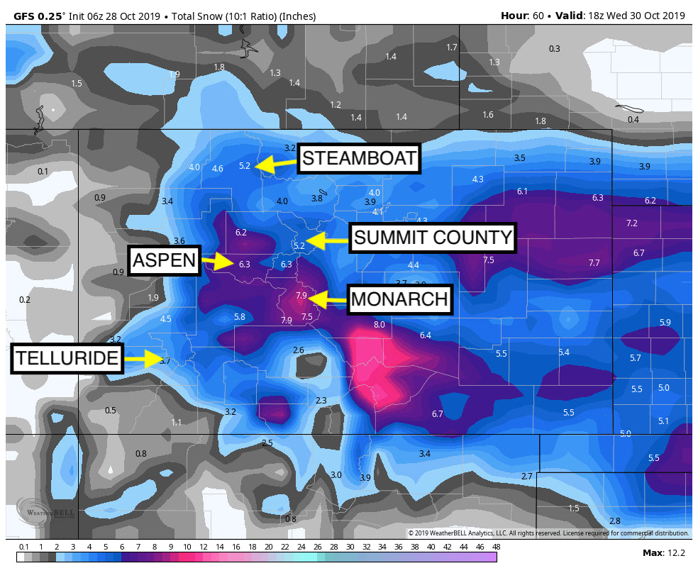
Is it really October? Temps are going to plunge into the single digits at upper elevations by Tuesday night with record lows likely being set in many areas of the Rockies this week. Arctic air from Canada will plunge into the Rockies tonight through Wednesday and kick-off moderate snowfall for most of the Montana ski areas (3-6), the Tetons (4-7), Wasatch (4-7), and Colorado (6-12). The Wasatch may see higher amounts in the Cottonwoods due to good NW flow behind the front. That is all dependant on lake effect kicking in which is certainly possible. Some isolated areas of the Cottonwoods could nab 9-14 inches. The system is not very moist so most ski areas in Utah should be in the 4-8 inch range with tlorado through Friday afternoon. Amounts will be higher due to cold temps and better snow ratios. You can almost add 50% to these totals or more!

Further north in Colorado some sneak up deepness might occur (Wildcard) Friday PM or Saturday. Ther models show decent snow for Aspen and Crested Butte (CB- 7-12- Aspen 5-10). What's interesting is that the moisture from the south is likely to push north and impact southern regions of Summit and Clear Creek County (South of I-70) both Friday and Saturday. Friday afternoon may offer some moderate to deep powder followed by another powder day on Saturday. Expect 4-7 inches Friday and perhaps a repeat for Saturday.
Elsewhere in the west, northern Utah simply gets teased with light leftovers Thursday/Friday. New Mexico will grab snowfall on the northernmost borders (Heaviest west of Taos). Taos might score late Friday to Saturday as a wildcard.
The Pacific Northwest will be addressed in the extended forecast.
EXTENDED
The Cascades ramp up again Friday night with a repeat of the Wednesday storm. Moisture will be streaming in with NW winds favoring the central and southern Cascades of Washington Friday PM. While the last storm outperformed at Crystal the next one may favor Stevens or Alpental. Expect 8-12 inches for 1st chairs on Saturday at many resorts in WA. Higher amounts will fall in the Oregon Cascades including Bachelor. Snow will decrease Saturday morning in Washington (Heavier in Oregon) only to start up again on Sunday (light to moderate refresh in WA). Ride Saturday and Sunday!
The long term outlook looks very moist for Oregon early next week. A steady flow of moisture will enter the Oregon coast late this week and early next. That moisture takes a straight line over Idaho (Sun Valley, Brundage, Central panhandle) and the Tetons. Montana is also likely to score! Expect a long duration event early next week for the northern Rockies. Depending on how far south that system moves, Utah may see some decent amounts favoring the northern Wasatch range (Beaver near Logan and Powder Mountain may be favored). Northern Colorado is a wildcard.
Enjoy the powder everyone.
Suport Ski ride Tours, Beaver Mountain, Snoshark, and our IKON partners who have sponsored Powderchasers this season.
Announcement:
Powder Fanatics!
- RT Air from a USA airport near you- 6 nights lodging, double occupancy, 2 beds per room- 5 days of skiing. (Cost per day will be deducted for those that may have a pass that applies)- All shuttles to and from airports and ski resorts- Staff/host on site- possible breakfasts depending on lodging
- Single supplement for private room will be available
- If a CAT or Heli-day option is available, we will let you know the cost


