
The past several days brought the highest moisture along the California Coast with soaking rains that spread north into the Sierra Range. While the southern Sierra scored the highest totals (13-18 inches at Main Lodge at Mammoth and opening Thursday), areas near Lake Tahoe were in the 6-14 inch range. We don't have official numbers from many resorts. Kirkwood may have scored an excess of a foot of powder. Palisades reported 8 inches. Lee Canyon, just outside Las Vegas, nabbed 13 inches! The next area to watch for snowfall is the 4 corners region, including southern Utah, Northern Arizona, and the San Juan Ranges of Colorado. New Mexico is a wildcard. Longer range models bring moisture back to the PNW and Canada.
The Big News! Jay Peak in northern Vermont has seen 89 inches of snow in the past week and is now racing towards 100 inches YTD totals before December. The northern Vermont mountains have exceeded all snow totals in the west.
Storm Recap- West
Below: Sesame Snow Study plot at 9K at Mammoth shows a jump in total snowfall (11-16-11-18) from 5 to 18 inches (13 new just above the Main Lodge). There are likely higher totals above 9K. They are reporting 2-3 feet at the summit.

Below: Mammoth Instagram Post on Tuesday morning. Looks deep.

Other unofficial numbers in the West
Lee Canyon (1 hour from Vegas): 13 inches
Snowbasin: 6-8 inches
Crested Butte: 4-6 inches
Aspen: 4-6 inches
Telluride: 1-3 inches
Monarch: 4-6 inches
Alta/Bird: 4 inches
Wolf Creek: 7 inches
Arizona SnowBowl: 3 inches.
Brian Head: 6-8 inches
Below: Base of Kirkwood is finally looking winter-like.

Below: Lee Canyon near Las Vegas. They reported 13 inches, so we guess that higher elevations have significantly higher totals than this base picture.

Below: Brian Head cleared off this snow cam since the storm totals, which we estimate at 6-8 inches. The trees look deeper.

OUR GOLD SPONSORS


FORECAST:
POWDER ALERT- Southern Storm for the 4 corners for Thursday/Friday.
A final surge of moisture is still lingering over Southern California on Tuesday morning. This moisture will tease the Lake Tahoe resorts with a few more inches of snow. Mammoth might grab 2-4 additional. Areas south towards Big Bear may reap higher totals near the summits. This moisture will track east over the 4 corners late Wednesday into Thursday (Wave #1). Another and stronger wave with slightly colder temps will bring another refresh to the 4 corners Wednesday afternoon into Thursday morning.
Below: Composite Radar from Tuesday morning into Friday. You can see the bands of moisture over California track SE over southern Nevada and northern Arizona before swooping north into Colorado midweek into Thursday evening.

Below: Additional snowfall for California on Tuesday favors the southern regions as moisture is decaying and moving towards the 4-Corners next.

Below: Moisture totals through Friday morning (Nov 21) are healthy in the 4 corners, especially Arizona, extreme southern California, southern Utah, southern Colorado, and northern New Mexico. The core of the Central or northern Rockies gets missed.

Below: National Blended Models showing 2 periods of snowfall hit Colorado this week, with the first minor bump on Wednesday PM into Thursday morning. This favors the southern San Juan Range (5-11). A cold front moves in Thursday PM to Friday, pushing the action further north for a Friday morning refresh. There is some hint of NW flow over Telluride Thursday night (Good wind direction for Telluride). The Front Range grabs Upslope Thursday PM to Friday and might see some snow along the Foothills and extending into the Divide resorts (Wildcard). There is a large discrepancy in the models shown below.

Below: The short-term NAM model is more bullish for the San Juans and pushes higher snow totals along the Front Range to about Jefferson County (Above 7500 feet). Less snow is noted for Summit County and areas near Boulder. Telluride and Wolf Creek would score double digits if this model proves correct.

Below: The GFS American model is even less bullish on snow totals for the San Juan Range (4-7), with little to no snow further north into the Front Range. The European model is also less bullish. There is a definite downside to this forecast if the deterministic GFS and Euro prove correct, pushing most of the action further south versus the Front Range. New Mexico and Arizona are still in scoring position.
 Below: Decent confidence exists for some significant snow totals for both Brian Head in southern Utah and the Arizona SnowBowl, Wednesday/Thursday.

Extended pattern:
The longer range models show an increased chance of significant high elevation snowfall for Canada late this week into early next week. The trend is for snow levels to start near 5,000 feet later this week (rain at the bases of many resorts) and slowly lower as precipitation ends early next week.
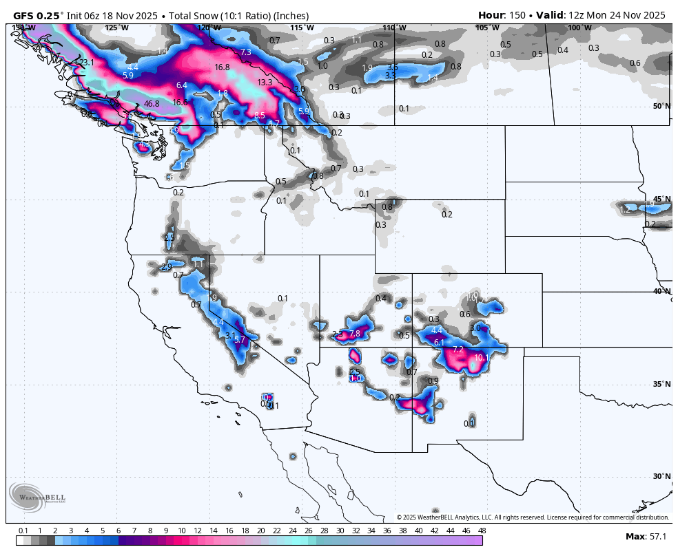
Below: 4-day snowfall totals ending Tuesday, November 25th. This will bring some significant totals to Canada and perhaps the northern Cascades of Washington. Snow levels are going to be high, with several feet likely above 5,000 feet. Rain will likley fall later this week below 5,000 feet before a cold front due around November 24th (Next Monday).

Below: 4800-foot temps from Friday this week (November 21) to Monday (November 24) fluctuate initially from near freezing in coastal BC, slightly cooler inland, and above freezing in the Cascades. Colder air moves in at the end of this loop early next week (-5C at 4800 feet shown for Monday (11/24), driving snow levels to most base locations as snow decreases.

Please support our sponsors! Tire Rack has a promotion on Blizzak Tires with a $80 prepaid Mastercard rebate with the purchase of any 4 tires. Please support your love of powder and our forecasts with a donation here, or join our concierge program.

Forecaster: Powderchaser Steve


