After being stuck in Little Cottonwood Canyon for over 100 hours, we were released this morning. This forecast is being written from the comfort of Ryan's Bagel down in Sandy, and that feels good. In the near term, the storm track will shift north, with a small storm this weekend and then a juicy atmospheric river early next week. Overall, totals aren't particularly impressive, but Washington and BC will see accumulating snow for much of the next week.
Powderchasers is going to be wrapping up its regular posts in the next few weeks. Please take this opportunity to support us! We are always looking for new sponsors for the website so please reach out to us at powderchasersmedia@gmail.com
Announcement: Please donate here. Donations keep our free forecasts going. Members rarely miss the deepest days. If you scored powder based on our forecasts (We run into you when we chase) please donate for powder! This is one of our last posts to do so.
Before we get into the details of the forecast, here are a few images from our five days trapped in Little Cottonwood Canyon.
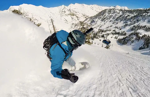
When the resort finally opened on Thursday, the snow was variable. But the mid-elevation northeast-facing slopes were deep and quality, as shown below by @lstone84. Check out the full edit from yesterday's riding here.

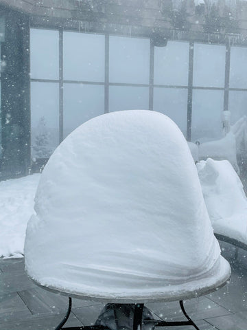
Snow is piling up on the chairs and tables outside the cliff lodge on Tuesday. Please renew your Ikon Pass with the link below for the lowest rates for the 23/24 season.

By Wednesday, tables around the rooftop pool/hot tub were looking incredibly deep.

All roofs at the base of Snowbird are completely buried, with massive piles of snow on top of them.

Looking down into the Sal Lake valley from the summit of Snowbird yesterday, after the resort finally opened.

And finally, the view, from our room at the Cliff Lodge, of the out of bounds avalanche that slid down into the resort. Thankfully no one was hurt.

All images courtesy of Luke Stone (@lstone84 on Instagram)
Snow is currently falling in the Northwest and in the far northern Sierra too. Snow will continue through the day across Washington, Oregon, BC, and the northern Sierra, moving into Idaho and northwest Montana this afternoon as well. Precipitation will taper off in coastal BC, Washington, Oregon, and Northern California this evening, but another wave of moisture will arrive overnight, focused on BC and Washington. Overall, only a few inches are expected across the aforementioned arras through tomorrow night.
The atmospheric river will accompany this second wave of moisture, bringing higher snow levels also, as a low pressure stalls off the coast. Rain and high elevation snow will continue from Saturday night through Sunday night, before the arrival of some colder air. Snow levels will climb over 4k in BC and over 5k/6k in Washington Saturday night and Sunday. Expect rain at lower elevations during this time, and maybe a few inches of snow at mid elevations across the region. Below you can see the river of moisture streaming into the northwest from the tropics.

There is not much moisture once the cold front passes, however the storm will soon make its way inland, and some additional showers will occur as a result. It will be cold enough for these showers to remain all snow in the mountains, from Monday afternoon through Tuesday. Several inches of snow will are likely during this period, and as the storm continues to track east, there will be some accumulating snow in Oregon, Idaho, Montana, Nevada, and Wyoming as well. You can see the snow totals from the American model below during this time.

As this storm continues to move south and east, it will split, allowing the southern piece of energy to bring snow to southern Utah and Colorado by the end of the week. There is potential for this storm to strengthen and ring significant snow to Colorado, but we will have an update on that later.
Beyond that, we may finally see a break in the storm activity across all of the west, as the models are showing a strong ridge setting up over the region. You can see that in the upper air pattern below, which is for the five day period ending on April 21st.

Beyond the third week of the month, the models are less certain about whether the ridge will stick around. However, there is also not a strong signal of a return to a sorry pattern either. Enjoy the potential break from storms, and hope for some more powder days later this month.
Thanks for reading the forecast. Follow me @lstone84 on Instagram to track and chase storms all Winter long!
Please don't forget to donate to our forecast team.


