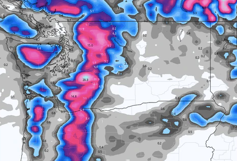
The next week for chasing pow looks to be decent for areas of southern interior Canada, PNW, and perhaps Montana extending into Colorado by late in the week. This won't be an epic 24-hour double-digit event, but the sum totals could bring some great riding early this week in the PNW and late week for the Rockies.
Currently, the PNW is on the warm side with light snow falling over Mt Baker, and rain further south at Stevens Pass. 12 inches of snow just landed at Whistler for Monday morning. Colder air late Monday into Tuesday will bring 4-8 inches to many of the mountains of the PNW, with perhaps higher amounts for Mt Baker. Models show some decent totals through Tuesday from the western Cascades of Washington extending into northern Oregon. Quality will improve Monday night so conditions might ride pretty well (Dense to cold). Some decent snow totals are also noted in southern BC just above the Idaho border.
For the Rockies snow skirts out of the PNW later this week. The models favor areas of the Panhandle of Idaho, central Montana (Bozeman or north), and eventually Colorado for Thursday night or Friday. Utah is going to be brushed with cooler temps and some lighter snow totals. Some sneak-up surprises could occur near Bozeman or the Front Range of Colorado.
Below: Total snowfall for the PNW is decent through Wednesday. This is initially warm on Monday and migrates to more winter-like temps Tuesday-Thursday. No single double-digit 12-hour dump, but certainly 12 plus over 24-48 hours. I would aim for Tuesday morning. Totals might be a bit higher over Mt Baker with slightly colder temps on Monday (Snowing currently). Rain is falling at the bases further south that will change to snow late Monday. If you are chasing pow next season check out the lowest rates on the Ikon Pass below.

Below: Cold temps at 4800 feet (-6C) are noted for the PNW and Canada this week while the Rockies stay warm until later this week. These temps are more representative of mid-winter for the PNW. The Rockies are well above normal currently but cooling late this week.

Below: Grabbed my Ibis Ripley which has not moved since November last weekend and rode Slate Canyon near Provo Utah. This felt really good to be on dirt again, but obviously when the snow returns I will be on it. Photo: @powderchasersteve via Instagram

Below: The models showing total snowfall for the Rockies favoring areas north into Montana and Idaho skirting the Tetons and landing in much of Colorado by the end of this week. Winds are easterly along the Front Range and SW migrating to NW along the I-70 mountain corridor of Colorado. This might bring some upside totals to resorts closest to Denver (A-Basin, WP, RMNP, Eldora, Loveland). NW winds further west should also allow a widespread area of snow to fall on the western corridor. While not a huge event, the totals could be chase worthy especially for mid-April where we get to "Take what you can get". This will be updated on Wednesday.

Powderchasers is going to be wrapping up its regular posts in the next few weeks. Please take this opportunity to support us! We are always looking for new sponsors for the website so please reach out to us at powderchasersmedia@gmail.com for being featured on the website.
Donate here. Donations keep our free forecasts going. Members rarely miss the deepest days. If you scored powder based on our forecasts (We run into you when we chase) please donate for powder! We need your support to continue free forecasts.
We will update this feed on Wednesday. Thanks for reading.
Powderchaser Steve @powderchasersteve on Instagram


