Summary:
No significant storms until at least December 11th. One exception might be the Pacific Northwest that will once again see snowfall early next week. Weak leftovers will graze the Rockies. Mid to late December looks promising! Keep reading if you want to score deep powder.
Forecast:
On Wednesday we chased to Mt. Baker Ski area for our first day riding lifts. 7 inches fell on the telemetry since closing Tuesday. It had rained at the base previously so snowfall from Tuesday from mid to upper elevations only added to the official 6-7 inches on the snow report. Surprisingly it was deep up top (10-12) off piste, 7-8 on the main runs and of decent quality. Our efforts to get there was a 3:45 AM wake up call in Seattle and after nearly 3 hours of driving ended up being the 1st car in the parking lot. That was not easy! Even beat one of our other members of the Powderchasers crew, Blake, who conveniently got to stay in the closest lodging accommodation possible to Mt. Baker Ski Area thanks to Mt. Baker Lodging.
If you are in Utah up to 5 inches has fallen at the upper elevations of the Cottonwoods- Taste of winter.
Below: Powderchaser Steve at Mt. Baker Wednesday morning. Follow: @powderchasersteve- Instagram

Meanwhile this week Colorado saw some pretty hefty snowfall amounts and in some cases resorts that really needed it. Below: OpenSnow snow totals for Colorado as of Wednesday morning- Joel Gratz
Here is the storm total snowfall between Sunday night and Tuesday night:
Northern Mountains
16\" Keystone
12\" Breckenridge
11\" Arapahoe Basin
10\" Loveland
10\" Winter Park
9\" Copper
7\" Beaver Creek
7\" Vail
6\" Eldora
6\" Ski Cooper
4\" Steamboat
Central Mountains
8\" Crested Butte
7\" Aspen Highlands
7\" Aspen Mountain
6\" Monarch
6\" Snowmass
4\" Buttermilk
Southern Mountains
16\" Wolf Creek
12\" Telluride
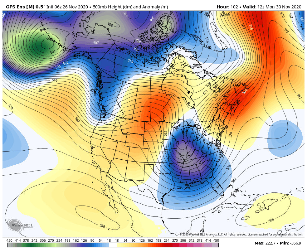
During the next 7-10 days moisture will be forced north over a ridge of high pressure over the Rockies. The deterministic models show a good chance of moderate to heavy snow for the Pacific Northwest beginning late this weekend. That system could produce a foot or more of decent quality powder for certain areas of the Cascades. Models show moisture weaning as it drags over the Rockies bringing a chance for some light snow mid next week to Wyoming and Colorado.
Below: Strong low pressure over Canada early next week edging into the Pacific Northwest.

In looking at the ensembles and operational runs the west will be under strong high pressure until at least December 11th or 12th after the departing storm early next week. The mid or latter portion of December looks promising for some welcome pattern changes. Both the operational and ensembles seem to agree that we could be in for a stormy mid to end of December.
Below: GFS EXT ensembles showing a possible pattern change for stormier weather for the west at some point on or after December 11th.

Announcement:
Overall, its been a decent start to the season for many areas (Hence the Chase Forecast). For those areas that have not seen much snow remember that even 1 or 2 storms can land several feet in a short period of time. There are many occasions when we have went from Zero to Hero. Its only November! The long term trend is in the right direction!
Happy Thanksgiving! Enjoy the powder and stay safe especially if you are in the Backcountry.
Powderchaser Steve


