Summary:
High pressure has settled into most of the west. Alaska nabbed 12-17 inches yesterday with rain at lower elevations for Aleyeska and snow continuing at upper elevations. Heli-skiing could be an option once the weather breaks for AK. High pressure will break down midweek for the Sierra (Moderate storm) that drags over the 4 corners by Thursday. The Cascades also see teasers by the weekend.
Forecast:
Mid-mountain bases tipped the 100-inch mark last week for Telluride, Purgatory, and Monarch (All over 100 as of last Thursday). Wolf Creek is at 174 inches! Park City at 118, and Alta at 158. Bachelor is at 158. Squaw is at a whopping 225 with over 600 inches for the season thus far. Grand Targhee is at 430 inches YTD. What a season thus far with nearly every area of the west having an epic season. Hopefully, some of you have been able to chase powder.
As we come into Spring expect more opportunities for powder and the game of late storms into April and May providing a good opportunity to hopefully score a \sneak up powder day\". In the extended forecast there appears to be a good chance of snow continuing especially late next week or the following.
Alaska may continue to see moisture for much of this week, however, warm temps will provide rain at lower elevations and significant snow at the summits. Alaska Snowboard Guides sent me a video this week that looked pretty deep on Thompson Pass! They provide skiing and boarding.
If you're riding the slopes in the next few days out west, consider the best conditions mid to late AM or afternoon as the chalk softens up (Ice layers in the morning due to colder temps).
Extended:
A low-pressure system will enter the Sierraby Wednesday. The southern Sierra may be favored. Moderate snow will drag over this region midweek with the current path focussed on the 4 cornersof AZ/CO/UT/NM. The GFS is very bullish for Telluride where the Euro models are taking most moisture south and east. I am not overly confident for any area right now but suspect the southern resorts from Purgatory to Wolf Creek are favored. Some snow will also be falling at the Arizona Snowbowl albeit light. Due to a possible upslope scenario, it's likely that significant snow will be falling along the plains of New Mexico (East of the ski areas) with more moderate snow towards Taos or Santa Fe (Santa Fe favored).
Below: The optimistic GFS model bringing in decent snowfall for the 4 corners, especially Colorado and New Mexico late this week. The Euro pushes more moisture south or east. The 15 inches on the map is Telluride but confidence is lacking currently due to wind directions and models being 5-7 days out.

As we approach next weekend, a moderate system with cold air is likely to impact the Cascades or Washington and Oregon (Friday-Monday). This does not appear to land any single heavy event but might bring a consistent fetch of snow showers to many areas through Monday (Friday or Saturday will see the heaviest amounts).
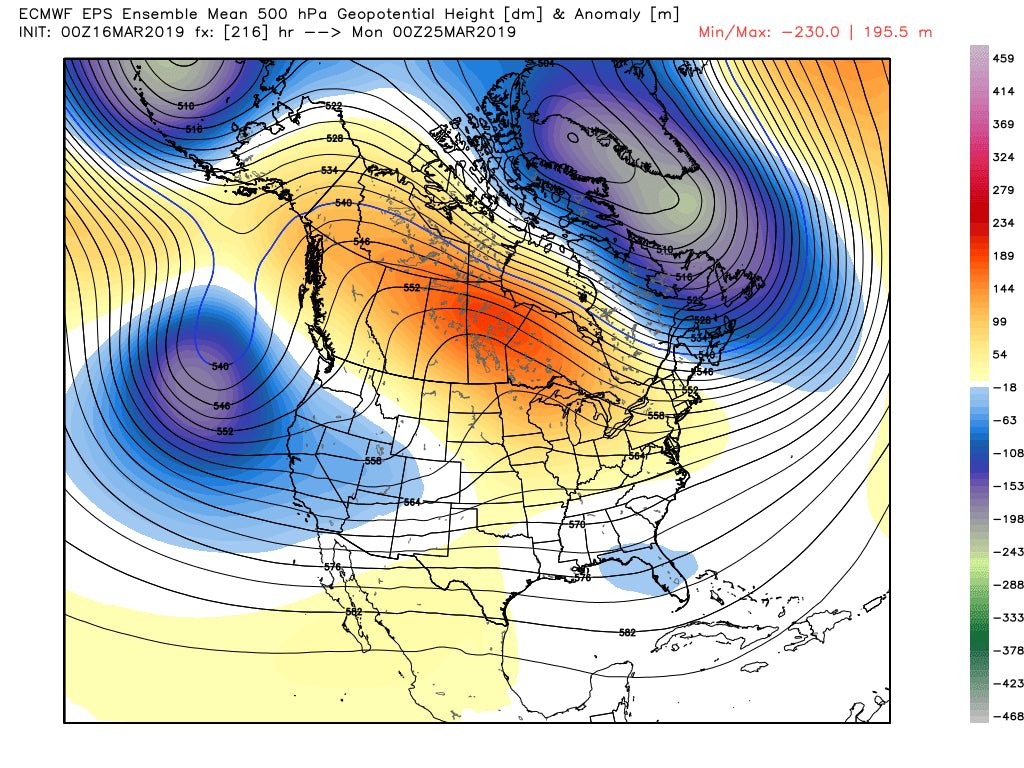
In the super extended range, the final week of March looks unsettled per the latest ensemble runs favoring the Sierra and the central Rockies.
Below: Ensemble runs showing a chance of troughs moving in during the March 25th and beyond timeframe.

Enjoy the powder (If you find some). Spring is around the corner! I'm already starting to think about mountain biking but know that many more powder days are ahead! My season won't stop as long as there is snow falling!
Powderchaser Steve


