We are approaching the end of our frequent forecasts and encourage all of you to please donate on our website or purchase the swag. The donations help us more so if you have taken advantage of chasing powder, or living vicariously through Powderchasers please contribute here. We survive on your help from the powder community. Donate: https://powderchasers.com/pages/donate-to-powderchasers
Swag is available here with a special discount on all shirts using discount code "spring" https://powderchasers.com/collections/frontpage
Below: Snowbasin on Monday morning. This stake is a bit hard to read with the actual total near 4-5 inches and the bump closer to 9. The actual report on Monday was 3 inches. My estimate 4-5.

This is a quick late PM update, primarily for Colorado Powder. Our storm in Utah underperformed with my last forecast indicating there was a chance that 2-4 inches fall in the Cottonwoods. While I was more optimistic of 5-10 inches or even higher amounts NWS had 11-17 inches even on the morning Cottonwoods forecast. The models simply had so much disagreement that confidence was not great. I also mentioned it being pretty unusual to see so much uncertainty on a storm day. Unfortunately, some models showed a skunk hole over the Cottonwoods who ended up with 2 inches as of 5 PM Monday. Snowbasin seems to have fared better with 3-6.
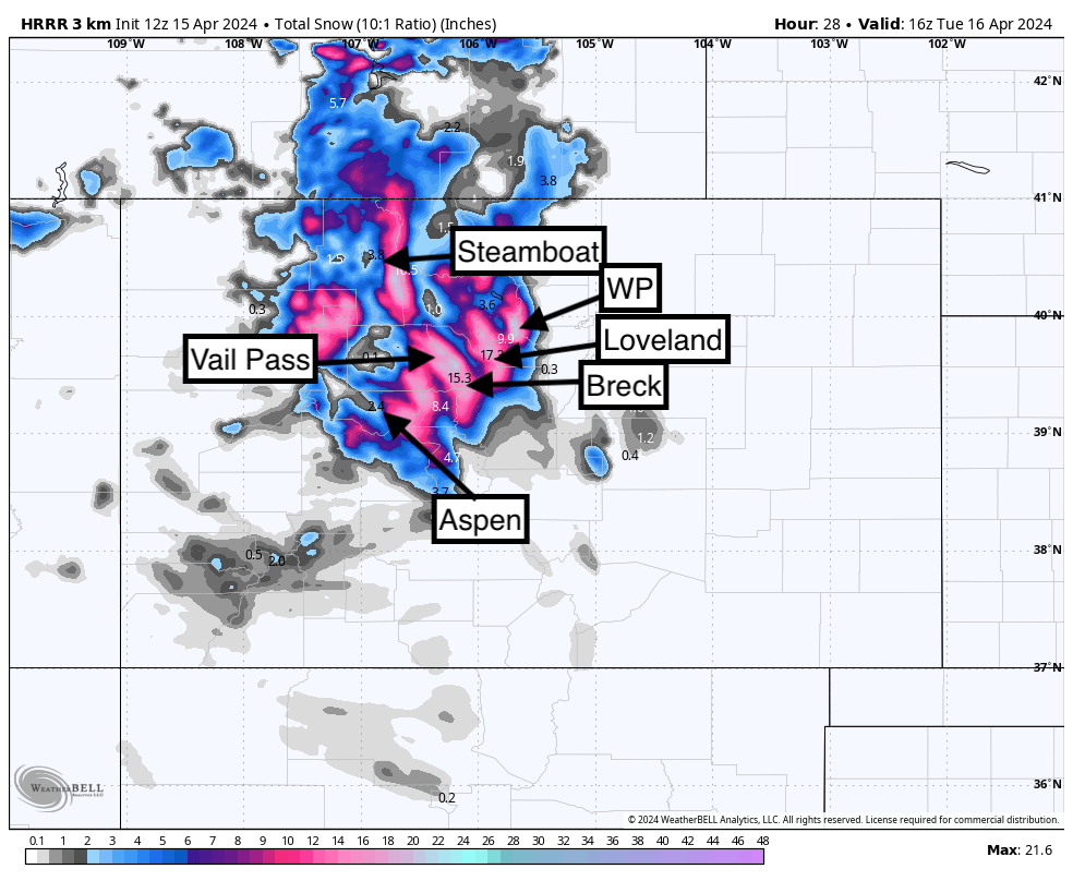
I have higher certainties in Colorado from Monday night to Tuesday late AM for many areas to report 7-15 inches of snow. The high-resolution short-term models are pumping out decent totals for all mountains from the Front Range Divide extending into Summit County and west to Vail. NW winds can often perform well here. The deterministic GFS and European models favor the Continental Divide from RMNP to Winter Park and extending south to Loveland Pass. If these models pan out we might see lower totals for Summit and Eagle County.
Caveats: While the timing of this storm is great (Monday night to early Tuesday) cooler air brings snow levels to nearly 7,000 feet and then rapidly rises to nearly 8500 or 9,000 feet on Tuesday morning. Medium to dense snow Tuesday night will turn full-on dense with rain even possible at some of the lower bases or Valley locations. This is not a perfect storm density-wise but is exactly what we needed to cover up the mank below. I would plan to chase some guaranteed surf with this storm. Avy danger will be rising so please use caution if you venture into the backcountry (Warming on Tuesday).
Bottom Line: Great timing. Excitement for mid-April Powder. Surf time. My expectations are 5-12 for many mountain locations with some outliers reporting higher totals closer to the northern Divide (North of I-70). Due to warm temps, especially Tuesday near daybreak lower elevations or bases might come up with 2-5 and higher peaks with 5-12. It would not surprise me to see some resort summits with higher totals.
Below: A cold front noted Monday night (-4 C at 10K or 24F) bringing dense snow to the mountains is quickly replaced by warming on Tuesday to near or above freezing at 10K. you can see plus 2-3C at 10K by Tuesday morning which is then replaced with cooler air later in the day. We might see some terrain closures depending on the Ski Patrol work on Tuesday. The backcountry might be an area to avoid.

Below: Short-term HRR models are the most bullish for most of the core of I-70 and areas north. The GFS and European are a bit more leaning on areas closer to the northern Front Range mountains. I am leaning a bit towards this solution where there are few losers with this storm. Temps might keep totals much lower, especially at the bases. I am going with a general broad-brush total of 5-12 with some upside at higher-elevation resorts especially north of I-70. The spread of totals reflects the lower totals at the bases. This solution and the NW wind direction should allow most resorts to report decent totals on Tuesday.

Below: NAM 12 (Another short-term model) pushing the highest totals further east towards Loveland Pass and Winter Park with lower totals for Breckenridge or areas west to Vail Pass. The Deterministic models show a similar solution.

See you on the first chair on Tuesday. This might be a pure novelty chase for April snow. I don't expect major highway issues aside from the higher mountain passes on I-70 due to warmer conditions, especially by daybreak on Tuesday.
3 days left to purchase your IKON PASS at a discount here
Montana?
Montana still looks good for Tuesday night with colder temps and 6-15 inches of snowfall favoring areas near the Wyoming border perhaps closer to Red Lodge (Closed). Areas towards Big Sky are a solid wildcard. The Tetons will sneak out some snow (2-5) but it might be confined to the northern areas of the park. Montana form a quality standpoint looks the great (comes in warm and finishes cold).
SPRING DISCOUNT ON ALL PC SHIRTS NOW.
We have new Powderchasers shirts fresh off production for sale currently for just $32 (Front and back powder). USE DISCOUNT CODE "spring" TO RECEIVE A 10% DISCOUNT ON ALL SHIRTS THIS WEEK.


Powderhcaser Steve


