
Utah- Cusp of Cold Air- Might Boom or Bust.
On Saturday night, the models gave us a bit of a pause on any significant snowfall for the Wasatch range by Sunday morning. Telemetry is showing storm totals as of Sunday morning in the Cottonwoods at 7 inches (Saturday and Saturday night) above 8,000 feet. We are still on the warm side of the storm. This was pure cream Saturday and Saturday night (Temps near freezing at upper elevation)
Snow will increase in Utah as a cold front approaches by mid-Sunday morning and ramps up totals for most areas. Our concern is that the coldest air remains a bit west of the Wasatch Front and eventually reaches Utah late Sunday when the winds shift to a northerly direction. North winds will decrease snow intensity for most resort locations and keep snow totals lower. My estimate is an additional 6-12 inches from late AM Sunday to Sunday evening when the flow switches northerly and keeps light snow showers going. Storm totals will likely still approach our original forecast of 12-16 inches above 8,000 feet (6 so far at upper elevations as of 5 AM Sunday at Alta). The bases will see much less snow. Park City might come up a bit short in the 3-8 inch range from mid or upper elevations (Canyons side). Areas in southern Utah (Eagle Point) might do well as the main core of the low drags over central Utah and clips the far south. Snow intensity is increasing over the Cottonwoods as of 7AM.
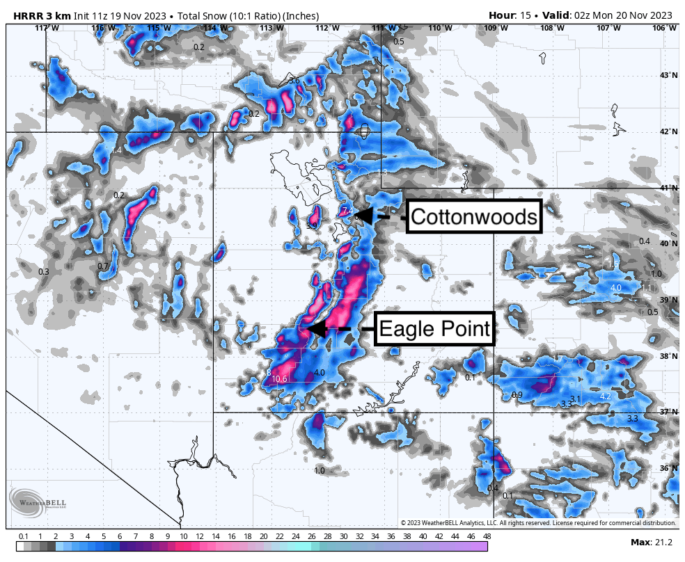
Below: Short-term model data still indicate some strong snowfall intensities for Utah on Sunday. Further north towards the lake, the pink areas are the Cottonwoods. You can see the bulk of the moisture is dropping south so some good numbers might come up towards Eagle Point or Brian Head. The central mountains seem a bit more favored outside most ski areas. We would not be surprised to see an additional 5-10 inches for the Cottonwoods and 3-7 for Park City Mountain (Canyons side) by 4 PM Sunday.

Below: The coldest air remains over Nevada through late Sunday. Utah is cooling, with snow increasing, however, the brunt force of very high snow ratios is lacking with -7C at 10K. The coldest air reaches Utah late Sunday as the winds veer Northerly which will weaken the orographics for heavy snow Sunday evening.

Below: Northerly winds by late Sunday night will decrease or completely shut off additional snowfall for most of Utah. The gamble is how long we can hang onto NW flow Sunday. Wind will shift this evening to the north.

Sierra Bust? Need more upper mountain data. The storm is ending.
Telemetry at 8,000 feet at Palisades is showing 4 inches of new snow overnight. It's possible much higher amounts are located at the summits, but with no ski reports or any other data, our initial feeling is that CA came up short at mid-elevations but may be higher at the peaks. At Mammoth, the Sesame Snow study plot at 9K feet is showing a storm total of 8 inches with 6 inches in 24 hours. There is not much on the radar currently so our guess is that many ski resorts came in with 4-9 inches versus the higher totals in the forecast. More data later. The northern Sierra forecast of 7-13 likely was on the high side (We shall see).

Sponsor Alert: This post is sponsored by Skis.com and Snowboards.com. Powderchasers supports them being family-owned and with a vast selection of quality gear and clothing. We will donate a PC tee shirt for every purchase over $200 (Email us). They have an incredible selection. Please support them.
PNW- Gamble on a convergence zone- Very Cold Temps.
Generally a few inches thus far for the PNW with the short-term models still advertising a convergence zone setting up over Stevens Pass as of 5 AM Sunday. Very cold air is dropping snow levels to 2500 feet Sunday with snow ramping up Sunday morning. It is likely that 4-9 additional inches fall over the central Cascades of Washington by 6 PM Sunday. Alpental telemetry shows 5 inches but I don't believe it is working properly. If the cards all come together for the convergence zones (Westerly flow of cold air) things might end up higher. NWS still has significant snowfall for Oregon. The short-term models show the highest odds near Timberline or Mt Hood (North) versus Bachelor (currently snowing lightly). We are less optimistic for Oregon than the central Cascades of WA.
Colorado and New Mexico- Slim pickings.
The first part of the storm dragged up from the south on Saturday and delivered 1-4 inches for most of the central and northern mountains. (3 inches at Vail - Aspen- 4 inches at Irwin Lodge). Additional snowfall is likley into Sunday evening.
As mentioned in previous forecasts, we are only optimistic for western areas of Colorado and especially the northern San Juan range (Telluride, Red Mountain Pass) for 4-9 inches. Further east over the core of I-70, we are not expecting any significant snowfall (2-5 additional). Aspen is a decent wildcard sitting further south and Powderhorn sitting further west. Overall, the pickings will be on the lower end of things. our original track of this storm seems on target from yesterdays forecast. The head start on Saturday will help in the totals we find by Monday morning.
Below: Total additional snowfall favoring the north side of the southern mountains as the flow turns NW and the jet takes most of the moisture south. Confidence is pretty low with this storm since convective cells will significantly determine where the heaviest snow falls (Isolated pockets). Even Summit County could see a strong cell, but the odds of a deep dump are slim. NM gets leftovers.

Announcement: Please join our concierge program to support powderchasers. This program provides 1:1 forecasting, chase locations, and custom trip planning to get you in the deepest snow of the season. You can also donate on our website or purchase some swag to support us.
You can follow my passion for photography and snow on Instagram @powderchasersteve
Enjoy the powder, everyone! More snow is likely near or just after Turkey Day!
Low tide and increasing avalanche danger risks!
Powderchaser Steve


