
The Sierra will score 12-15 inches along the Sierra Crest from Saturday to Sunday (3-6 at lower elevations). This is a big boom for California. The Cascades will also score this weekend with 6-12 inches of snow, especially Oregon. Stevens Pass in Washington or even Alpental may also grab decent amounts if a convergence zone forms. If resorts were open we would be chasing to from the central or southern Cascades, Sierra and eventually to the Rockies this weekend. Even southern resorts in Colorado who have had little to no snow this season will grab a moderate tease. New Mexico is on the map as well.
Our forecast below will primarily address Colorado and Utah.
Utah and Colorado will see notable snowfall this weekend, providing a much needed boost to what has been a dismal start to the season thus far.
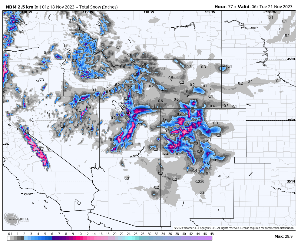
In Utah, light snowfall will begin on Saturday and will bring a dusting and high snow levels. The main snowfall event kicks off early Sunday morning as. a cold front approaches from the west. Snowfall rates will peak early Sunday morning before decreasing into Sunday night. Winds from the NW are ideal for the central- northern Wasatch initially (Cottonwoods, Areas of Park City, Powder Mountain). The joker in the mix is a switch from NW Sunday morning (Heaviest precipitation rates) to north in the afternoon. This will decrease intensity (W, NW, SW is best). In terms of totals, Wasatch resorts will be the winners in Utah. Due to the warmer temps initially, Cold temperatures and abundant moisture should bring 10-16" at upper-mountain elevations. Snow levels drop to 7000 feet after midnight Saturday and 6000 feet Sunday (Base elevations will grab 5-10). Several models are sending totals in the region beyond 20”, so there is certainly good upside to that range... but it's always better to be pleasantly surprised than bitterly disappointed! Temperatures will be in the 20s at upper elevations which will make for good quality base building. Below is the European model on total snowfall through Sunday night. These numbers will likely trend higher due to colder temps and better snow ratios Sunday (15:1). Shown at 10:1.

If you are planning on getting out and skiing/riding some of this early season snow, please remember that conditions are extremely low tide right now and season-ending sharks are lurking beneath. Avalanche Danger will be rising rapidly. Remember the last storm in the Wasatch put down .9 inches of water with only 4 inches of snow.
Colorado's forecast is a bit less certain. Models are indicating the first snowfall to arrive in the San Juans in southern Colorado on Saturday morning. It will surge to the northeast over the course of the day. This first wave won’t bring significant snowfall accumulation, with 1-3” expected for mountains across the state, favoring the central and southern mountains (South of I-70). However, the second wave will be the moneymaker for this system, favoring the central and southern mountains. Snowfall rates will be highest on Sunday evening with a cold front. Things should be mostly done by Monday evening.
In terms of storm totals, the best odds are widespread 3-8” totals for the San Juans with up to a foot or more in the higher terrain near Telluride. Wolf Creek looks good for 5-9” however Northerly winds on the backside of this storm are not ideal (SW is best)/ Further north in the central mountains, Aspen is looking at 5-7”, Vail at 3-5”, and Summit County resorts are looking good for 4-7”. Up north, Steamboat should sneak out 2-4”. Strong northerly winds on the tail end of the storm could allow Snowmass to out-perform the forecast by a few inches, so keep an eye on that. Areas west towards Grand Junction and Powderhorn mountain might also land a decent surprise.
Below: You can see the wind bars are due northerly on the backside of this storm (Sunday night to Monday). This is not an ideal wind direction for the western mountains, but could sneak up some surprises near Snowmass or south towards Telluride (A bit of a mystery). West, SW, NW are ideal for the western slope, NE and North for the Front Range. We are a bit more skeptical when we see winds from the north.

Looking ahead into next week, a strong ridge will set up over the west, steering moisture and cold temperatures to the north:
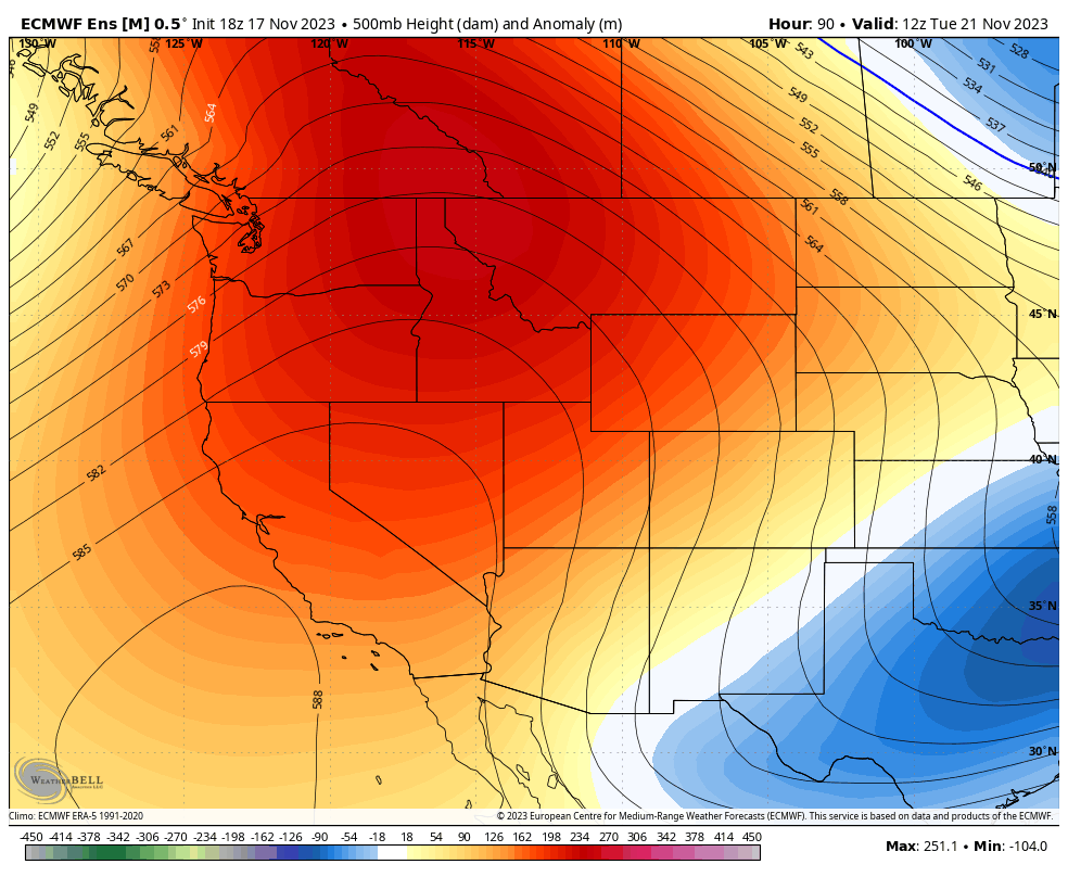
Models are still having a hard time resolving exactly when this will break down, but it does look like there could be a little clipper system sliding down the Intermountain West (Idaho, Montana, Wyoming, Utah, Colorado) late next week, likely Thursday (Turkey Day) and Friday. Details still remain blurry, but chances are this will be a very minor system and is not expected to bring significant accumulations at this time. Still a long way out, but check out how the European ensemble is steering this system in the west:

Announcement: Please join our concierge program to support powderchasers. This program provides 1:1 forecasting, chase locations, and custom trip planning to get you in the deepest snow of the season. You can also donate on our website or purchase some swag to support us.


