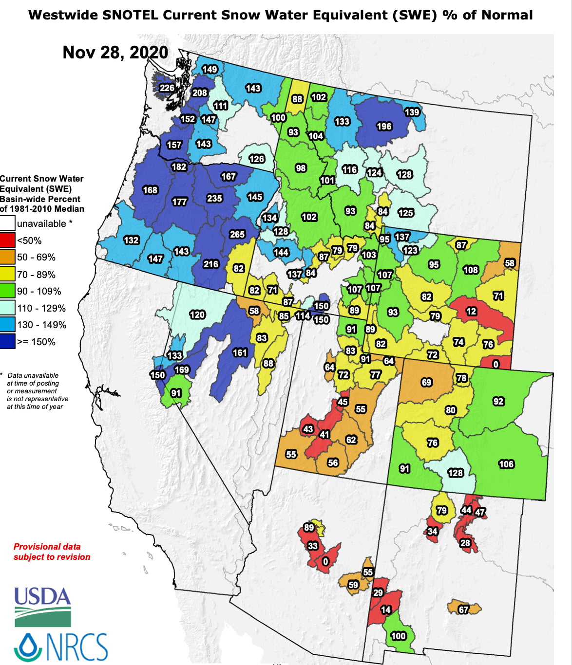
The weather pattern so far this season has delivered the most early season snowfall to the pacific northwest. This is expected with a moderate La Nina in the equatorial Pacific Ocean.
Before we dig further into the details, we wanted to remind you to sign up for the Powder Concierge. The Powder Concierge is a service we offer that provides custom forecasts to help YOU ensure the deepest possible powder days. With the numerous restrictions in place due to COVID 19, getting the best conditions when we DO ski/ride is more important than ever. To sign up or to learn more about the Powder Concierge, click here.
Below you can see the snow water equivalent percent of normal for the Western US this season. What the hell is 'snow water equivalent person of normal' you ask? Well one way hydrologists track the amount of water an area receives is by looking at how much water is contained within the snowpack. That is what snow water equivalent (SWE) means. If you melted down all the snow, how much water would it turn into. The percent of normal part refers to how much SWE does the current snowpack contain compared to the average for this time of year. As you can see, the pacific northwest is above normal to well above normal, and then the percent of normal decreases as you move South and East away from the northwest US.

(Courtesy of the USDA NRCS)
These maps definitely need to be taken with a grain of salt though. During the early and late parts of winter, October/November and April/May, the snowpack isn't very deep yet, or has melted out alot. Thus, early or late season storms can cause these numbers to be deceptively high. We're almost in December now though, so the above average numbers in the pacific northwest are worth noting.
Now onto the forecast for December. For the majority of our readers, who reside in the western US, the first half of the month looks like crap. The models are showing a blocking high, or ridge, in the western US for the first two weeks of the month. Below is the 7 day average 500mb geopotentiall heights for the first week of December. The yellow/orange/red colors indicate higher than normal heights, which equates to a ridge, over the west. This is up high in the atmosphere where the storm track is. That big ridge blocks storms from impacting the western US, deflecting them to the north or south.

(Image courtesy of Weatherbell)
For the second week of December, we see a similar pattern, with the location of the ridge in a slightly, but not significantly different, position.

(Image courtesy of Weatherbell)
For week two, the storm track does look favorable for a significant storm in the Northeast though. It's way too early for details but hopefully this pattern can deliver some snow to the Northeast. Beyond mid month, there is some hope for a pattern change in the west though. One thing we look at are atmospheric teleconnections. All this refers to is something in the atmosphere being connected to something else in the atmosphere a very long distance away. La Nina winters are associated with a negative PNA pattern, which is good for the west, and which we discussed briefly here: https://powderchasers.com/forecasts/e26761. The weather models actually specifically forecast whether the PNA will be negative, positive, or neutral. Below is the very long range (out to Jan 11th) forecast for the PNA pattern. You can see that around mid month the green line, or average PNA value, after being very positive for the first half of the month, crosses the zero line and goes negative. That's a little bit of hope for everyone in the western US.

(Image courtesy of Weatherbell)
In addition, the European weather model forecast keeps the PNA negative for quite some time. That would be great news for skiers and boarders in the west and would be typical for a La Nina winter. Keep in mind though that this is just ONE model's forecast of a potential pattern change in the very long range. All weather models lose accuracy the further out into the future you look, and this figure is looking at 14+ days and beyond, so this can and will change. Still, when times are bleak and the next two weeks look miserable, we have to find at least one nugget of hope.
That's all for now.
Powderchaser Luke


