This will be a quick overview of the upcoming weekend and early next week. We are actively looking to chase powder as much as you are! The PNW and Canada offer the best options currently. Low pressure is hung up over Canada late Friday through early Saturday before dropping south over the Cascades. Mt Baker will likely score some moderate powder for lift opening Saturday (4-6) with higher amounts noted for Whistler. Temps will start out warm Friday night quickly migrating to cold pow mid morning Saturday. To sum things up for the PNW \Long steady stream of light to moderate snow from early Saturday to late Sunday- slowly building with no epic 12 hour dump\". Moisture will favor the central Cascades near I-90 or Stevens Pass late Saturday to Sunday as west, NW Flow, much colder temps bring some hope for powder Sunday. Some snow showers linger into Monday Whistler well see most snow Friday night though Saturday morning (6-12).
Below: University of Utah Plumes showing slow but steady snowfall for Mt Baker early Saturday to late Sunday (Freight train chucking along slowly). Sum totals are pretty decent in the 9-15 inch range.

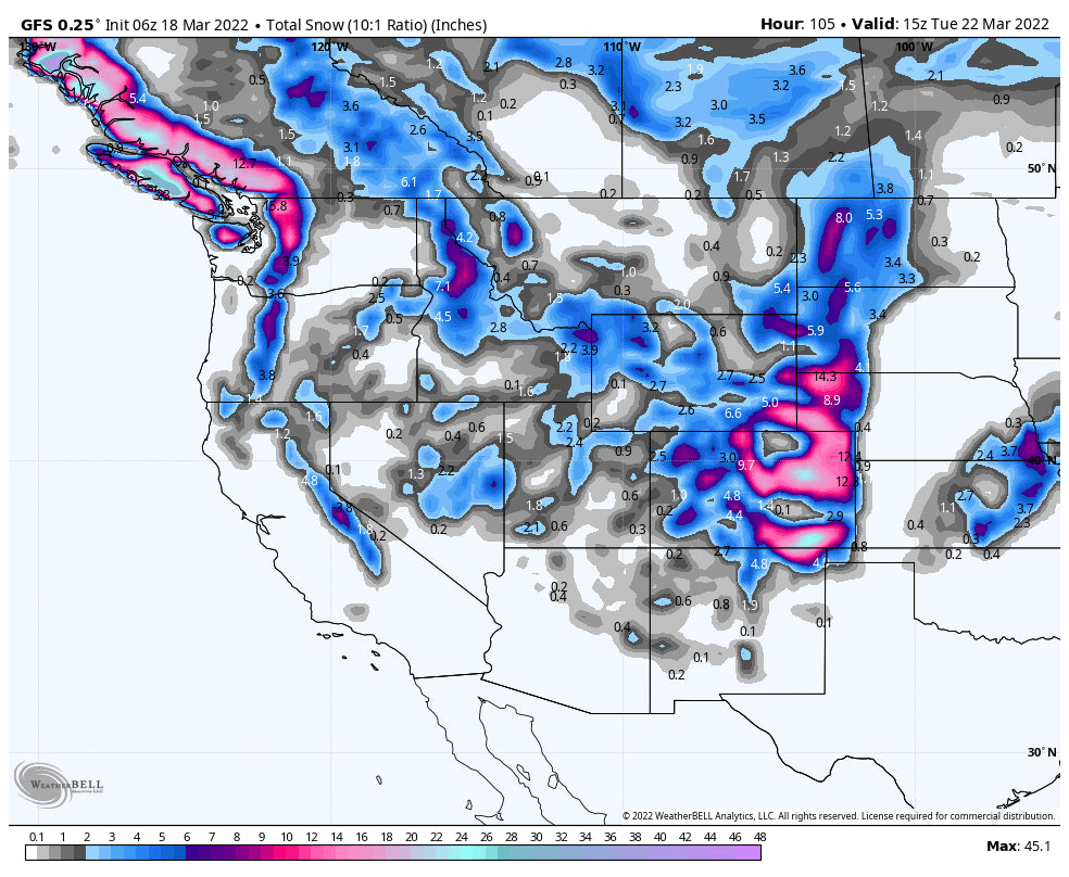
Elsewhere in the west, this low pressure from the PNW drops south teasing the Sierra by Saturday afternoon before kicking towards the 4 corners. This low will tap moisture from the south and spin slowly east with significant moisture pushing into Colorado. Currently, the models show different solutions. Some show the low dropping into Mexico which will limit snowfall for Colorado (SE corner, I-25, Plains). The other scenario brings it further north which might produce a deep dump for the Front Range Resorts (East side of the Divide) for Monday/Tuesday. Further west, along I-70 in this case would also see snowfall (light or moderate). It's simply too early to speculate until the models come into better agreement. Southern storms are pesky, dupe us, slow down, and hard to predict. This could be an epic Front Range March Dump or a complete dud. Stay tuned!
Elsewhere it appears that the Tetons and southern Montana (Big Sky, Bridger Bowl) grab a northern stream of moisture (Splits off the parent low) for Sunday/Monday. Montana may see a storm ski day Sunday with the Tetons by late AM The Wasatch Range of Utah will also be seeing snowfall from this event (4-7). Colder temps will produce high quality moderate powder for many areas. Look for some powder primarily Sunday.
Below: European Ensembles bringing the deep low south into Mexico by Monday which will push moisture north into New Mexico and Colorado beginning on Monday. This scenario keeps most snow south of the Denver area and focusses on the SE plains of Colorado and just east of many ski areas. Resorts further north would only see light or moderate snow.

Below: The American GFS has the low a but further north with decent snow totals for the Front Range resorts in Colorado. Heavy snow would result in this scenario for the Front Range Foothills and resorts, with moderate snow further west.

Stay tuned as we update this forecast as the models change. Please join our concierge or donate to powderchasers if you want to support our forecasts.
Powderchaser Steve - Instagram @powderchasersteve


