Happy Pre-Thanksgiving. This is Powderchaser Steve with your forecast. A decent storm and cold front is going to approach the northern Rockies by Thanksgiving morning. Many Ski areas will see snowfall, however the deepest totals might land in the wilderness areas of Wyoming, Montana with some better odds of moderate or heavy snow for the San Juan Range in Colorado or northern Utah that is a wildcard.
Montana/Wyoming
This will spread decent snowfall over the central portions of Wyoming extending north to the Montana border. Significant storm totals (12-16 inches) are likely for the Absaroka Mountains, Wind River Ranges. For Ski areas, we would put Red Lodge Mountain in as a wildcard, however wind directions are not ideal for significant totals (Need to watch). Further west towards the Tetons, we could see 3-6 inches. NWS has 6-12 inches for the Tetons currently, but we are not signing off on that just yet. Winds are easterly overt the Tetons that will limit amounts in western Wyoming. It's likely JHMR is favored overall with this system, but amounts to us still look to be on the moderate side primarily from Teton Pass and east.
Utah: While the Cottonwoods scored big time last weekend, this storm has less punch SW flow initially ending with NW flow as moisture decreases. The favored areas as early as late Thursday into Friday will be BCC with LCC close behind (6-10). NW winds late Friday to Saturday might sneak out additional totals favoring LCC. Park City and even areas north to Snowbasin can sometimes do well with SW flow (Aiming at 3-8 inches). Models also show some decent totals in southern Idaho near Twin Falls, Burley, and extending north to just south of Sun Valley.
Bottom Line: Strong contender for northern Utah for moderate snowfall with an outside chance of heavier totals. (BCC might be favored over LCC or areas east towards the Uinta Range). Heavier totals are likely in central Wyoming.
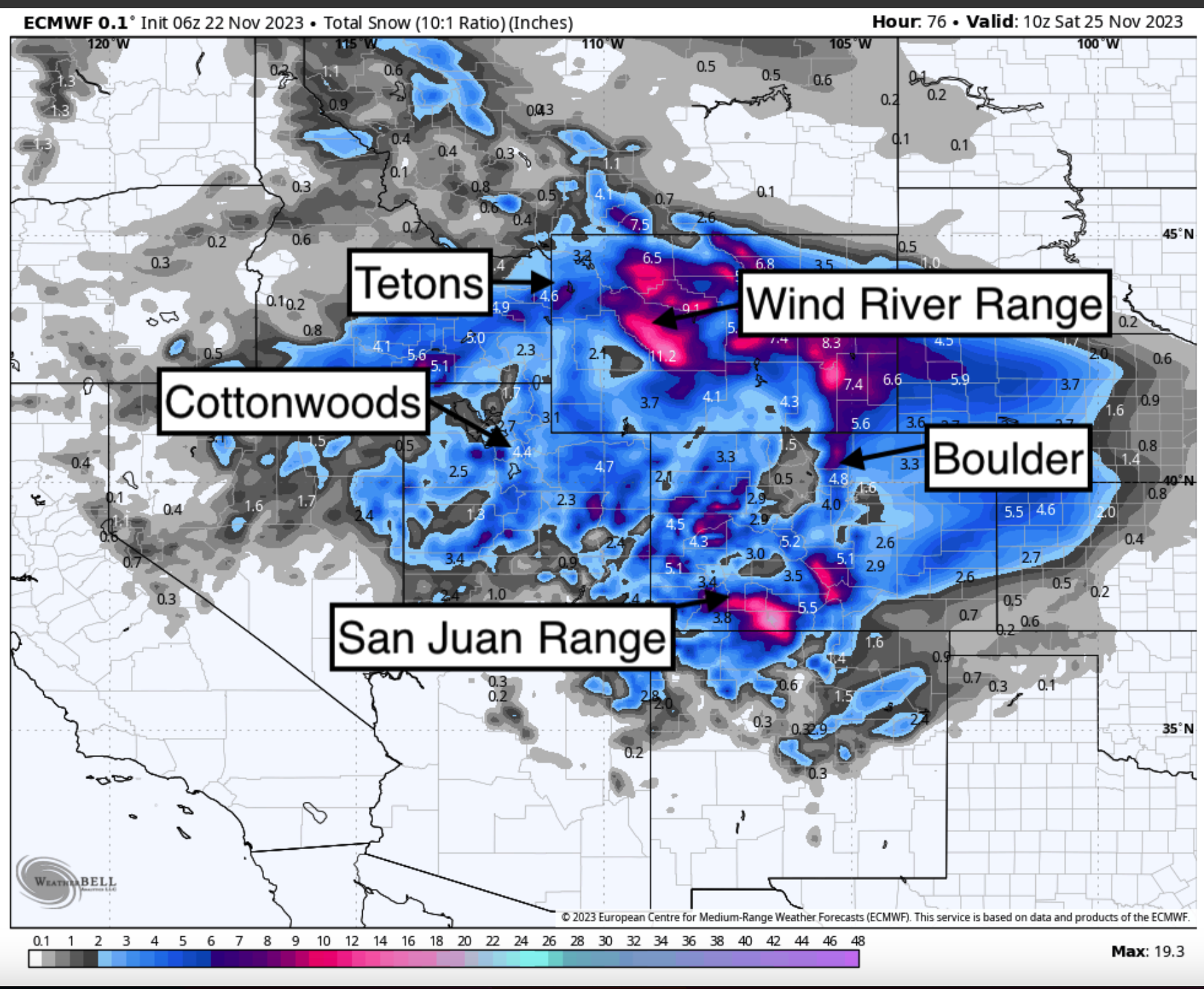
Below: The majority of snowfall through Friday night favoring areas of north central Wyoming, northern Utah, Southern Idaho, Wasatch Range, and most of southern or central Colorado including the Front Range near Denver.

Colorado:
This storm will drive south on Friday morning with very cold temps noted for the Front Range. Warmer air will remain west of the Continental Divide until Friday night. The focus of snowfall will be along the Front Range near Boulder, extending south to Pueblo and west over Wolf Creek pass. Decent totals are also likely for Purgatory with light or moderate totals north to Telluride, Crested Butte and Aspen. This storm has predominately SW winds which favor the southern San Juans. If enough moisture streams north we might see moderate totals at Crested Butte and Aspen (Wildcards). Areas near Boulder, Eldora, and Rocky Mountain National Park might also score with upslope conditions on Friday and very cold temps.
Below: University of Utah models showing 5-10 inches for Boulder through late Friday with most model solutions (Lines) in good consensus late Thursday to Friday PM.

Below: The cold front is overspreading Colorado Friday morning primarily along or east of the Divide (Temps are -15C at 10K). Bands of snowfall will accompany this front.

Below: Overall progress of the cold front on Friday mainly impacting the Divide, sliding south through Montana, Wyoming and Colorado. Northern Utah and ares of Idaho are also in a cool sector.

Below: Primary focus for snowfall in Colorado through late Friday night.
 We transition to high pressure in the west until perhaps early December when some storms are showing up on models.
ANNOUNCEMENT: Please join our concierge program to support powderchasers. This program provides 1:1 forecasting, chase locations, and custom trip planning to get you in the deepest snow of the season. You can also donate on our website or purchase some swag to support us.
Please follow my instagram page for photography, chasing pow, and world travel. @powderchasersteve
Powderchaser Steve


