Happy Thanksgiving! This forecast will be an update from Wednesday's full post. The storm is underway in the northern Rockies with snow falling over Wyoming. If you are looking for deep snow, we will highlight the deepest areas to focus on (Wyoming, Idaho, Utah, and Colorado updates).
ANNOUNCEMENT: Please join our concierge program to support powderchasers. This program provides 1:1 forecasting, chase locations, and custom trip planning to get you in the deepest snow of the season. You can also donate on our website or purchase some swag to support us.
Idaho/Wyoming
Models are in good agreement with heavy bands of snowfall near Pomerelle Ski Area near Twin Falls, Burley. Snow will edge north with lighter totals near Sun Valley (The further south you travel from Hailey the higher the totals). Timing: Thursday PM to Friday AM. This might be chase-worthy areas by Friday morning. Amounts: 7-15 inches at upper elevations.
Below: Southern Idaho near Twin Falls, and the Pomerelle Ski Area have consistently been bullish on the models for the past few days. The American model below shows less snow falling north over the Tetons with significant snow inland towards the central areas (Wind River Range extending south to the Laramie Range or north to Cody). In this model less snow was noted for the Tetons (Keep reading below).

The Tetons are currently nabbing decent snow intensity under easterly flow pushing moisture from the interior areas of Wyoming (Deep snow will fall over the Wind River Range, and Absaroka Range (Interior). The short-term HRR models are more bullish than the deterministic models above leading me to cautiously uptick totals for the Tetons even though the pattern is not ideal (Below map). Low confidence in a solution for the Tetons.
Below: There are indications of banded heavy snowfall over the Tetons on Thursday morning on the high-resolution model below. Amounts might end up higher than my original forecast. The deterministic models are less bullish. Wind direction from the N, N-East is not favorable for the ski areas. It's possible that 5-11 inches fall through Thursday night if you believe the short-term models. As of 7 AM Turkey Day, 2 inches is noted on telemetry at JHMR with Teton Pass snow-packed. The west side of Teton Pass will see less snow. Valley locations around Jackson might grab 1-3 inches. There is some downside potential due to easterly winds and the bulk of moisture noted east or south of the Tetons. Short term high-res model below is more bullish (5-11) than the above GFS. We are going with 3-7.

Below: Base of JHMR Gondola at 5 AM Thursday

Utah
In Utah, our forecast of 5-11 inches for the Cottonwoods is still on track for late Thursday night through Friday. SW flow during the bulk of precipitation favoring BCC with Sundance is worth a watch. The flow turns NW late Friday to Saturday which will keep light snow showers falling adding some super light-density fluff to what falls on Friday. Overall, this storm is cold with high quality. 3-7 inches are in the cards for the Park City area and areas north to Snowbasin (SW flow can sometimes be good for the Basin). Timing: Ride Friday as snow is still falling and getting deeper by early PM. Saturday will add some additional light accumulation fluff with NW flow. Moisture totals in the Wasatch are around 1/2 to 3/4 inch (8-14 inches). The exact track and when the winds shift to the NW will determine the upside and downside of this storm. I am confident for 5-10 inches for the Cottonwoods. BCC might over-perform.
Below: U of U modeling based on the GFS only shows a total of around 10 inches for the Cottonwoods by Friday night.

Colorado
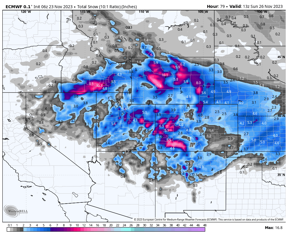
For Colorado, we have good confidence in significant totals for the southern San Juan Range on Friday/Saturday. 12-18 inches are likely for Wolf Creek and 8-12 for Purgatory, Red Mountain Pass, and perhaps Silverton. Telluride sits just north of the highest totals. Areas north towards Grand Junction and Powderhorn may also score decent totals (5-11).
Aspen, Crested Butte, and Monarch would be our next picks on the list with moderate snow. Some models show heavy snowfall for the Salida area that might skirt west toward Monarch Pass.
Summit County will likely sit in an area just west or north of the highest snowfall (Lower confidence).
In the Front Range, I am optimistic for 4-10 inches for the northern Foothills near Boulder and Fort Collins. RMNP, Nederland, and Eldora Ski Area would be on a shortlist. Timing: Late Thursday night peaking from early AM Friday to 3 PM. Caveat: Easterly winds will really favor the foothills as snow moves along the spine of the foothills. Much less snow will fall east towards I-25. It's also possible that less snow makes its way up to the higher elevations near the Ski areas.
Below U.of U modeling for Wolf Creek Pass shows a wide variety of solutions from 10-30 inches of snow. There is low confidence in this map (Widely spaced lines) but it is likely that significant snowfall lands here.

Below: Here is a likely scenario based on the European Model for total snowfall through Friday night. Aim to chase in the northern Foothills, Western corridor near Grand Junction extending south to the Southern San Juan Range. Central areas from Aspen, CB, and Monarch are wildcard picks.

Please follow my passion for photography, world travel, and powder on Instagram @powderchasersteve
If you read this far please please join our concierge program to support us. This program provides 1:1 forecasting, chase locations, and custom trip planning to get you in the deepest snow of the season. You can also donate on our website or purchase some swag to support us. Anything helps us keep the forecasts going. ANY DONATIONS OF $50 GET YOUR FREE STICKERS AND $100 GETS YOU A FREE SHIRT.
Thanks for following Powderchasers
Powderchaser Steve


