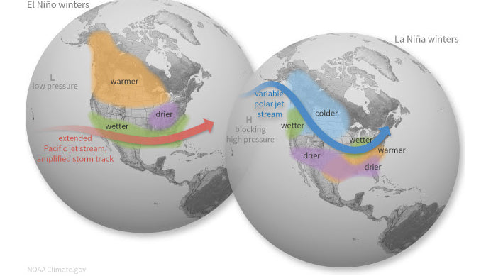
A La Niña Watch has been issued because conditions are favorable for the development of La Niña conditions within the next 4 months. We have been in an ENSO-Neutral phase recently which is defined by the surface water temperatures in the equatorial Pacific ocean running near normal compared to long-term averages.
Depending on which phase of ENSO (El Niño Southern Oscillation) we are in, it has big implications of what the upcoming winter will be like.
First off, what happens during each ENSO phase?

Since we are anticipating La Niña conditions, we'll focus on the right side of this image. Normally, high pressure will set up off the west coast of North America. Due to this, the storm track will allow for weather systems to track into British Columbia and the Pacific Northwest. This track will bring active weather into the central and northern Rockies, through the Great Lakes region and into the Northeastern US. This can also provide cooler temperatures for these regions.
This is the 'typical' setup of what generally happens. Of course there can be instances where we have a more southerly tracking storm but that should be the anomaly this upcoming season. For example last season with La Nina the Southern San Juan range of Colorado not typically favored, started the season with significant snow in November and December. While we can draw conclusions on storm tracks we are still talking about long range forecasts which can vary as La Nina is still developing and variability does exist season by season
When looking at the I-70 corridor of Colorado or the Wasatch of Utah, they often sit on the edge of the active storm track so typically don't see any real favoritism with La Nina or El Nino. Even the northern Sierra range can do well with both patterns.

Globally, weather will be influenced by the cooler waters in the Pacific. Our friends across the pond in Japan could expect cooler conditions and a solid ski season ahead.
Long-Range Forecast
The Climate Prediction Center issues forecasts months well in advance. They take into consideration aspects like which ENSO phase we are in and many other global, regional and local factors. Their forecast for the upcoming winter show that warmer than normal temperatures are expected for the southern and eastern US.

This temperature forecast shows that many mountain locations will run with near normal temperatures this winter with slightly warmer than normal temperatures expected at some ski areas. Prcipitation-wise, this winter is currently forecast to line up with the general thoughts of La Niña.

The northern Rockies, BC and the Cascades show promise of having more than enough moisture to work with this winter. The question will be, what will the temperatures be like? As we saw last year, we had several big storms but the rain/snow line was higher than wanted with several ski areas seeing more rain than snow at times.
Most ski areas across the country should end with near-normal snow for the entire season.
Key Takeaways
Overall, the trend of a La Niña winter is to bring ample snows to the Cascades, the northern Rockies and the Tetons. La Niña seasons can bring the Sierra Nevada and the Colorado Rockies hit or miss snows but enough to have a great season and awesome pow days.
Another factor to note is that when a La Niña winter follows a winter that also had La Niña conditions present (like 2020-21'), the second winter tends to be less impressive in terms of snowfall totals across the US.
The Climate Prediction Center is forecasting the winter (which runs from December through February) to have above normal precipitation in the Pacific Northwest with drier conditions across the southwest.
Announcement: Promotion for our concierge program- Anyone that renews or signs up prior to September 30th will receive a bonus forecast at no extra charge prior to December 15th. This is in addition to the normal custom forecasts.
Forecaster-Andy Stein


