
This post is sponsored by The Tire Rack, which provides the best wheel and tire options shipped directly to you or a Discount Tire store near you. Tire Rack has supported Powderchasers as a Gold Sponsor for 10 years. Click here for specials.
Below: Light snow showers will cover the west from Friday morning to Sunday. BC, Mt. Rainier, and Colorado are noted for a few heavier bands. Due to the warmer temperatures, 3-7 inches may fall in a few spots in BC and northern Colorado.
In Colorado, the models show the higher totals popping near Eldora or further west to Steamboat/Winter Park, especially on Saturday and Sunday. However, the models still show some differences in pinpointing these snow showers.

Below: This is the most bullish model (GFS) for totals in Colorado from Saturday to Sunday. Due to the warm temps, my confidence is low on seeing more than 3-7 inches of denser snow. Peak snowfall timing is 3 AM Saturday to 1 AM Sunday. Intensity will likely be on the low side. Slopes will freshen up Saturday with dense snow to cover up some of the chunder from the warmer temps in the past several days. Some leftovers fall on Saturday night.

The real story comes in the extended.
Extended POW
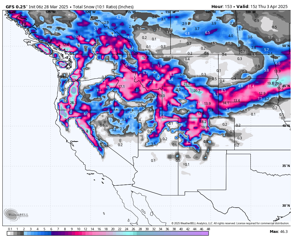
Below: Low pressure from Monday through Friday tracks over Oregon and the north central Rockies next week. High pressure is noted to return by next weekend, April 4th or 5th. This low will impact many areas of the west (Broad system).

Here are a few expected snow totals through next Thursday. Totals will be spread over several periods of snow from this weekend (Warm sector) to most of next week (Cold sector). Peak snowfall in the Sierra is on Monday, with the Rockies on Tuesday/Wednesday and again later next week.
Northern Sierra: 35 inches
Southern Sierra: 22 inches
Oregon Cascades: 16-20 inches
Washington Cascades: 9-15 inches (Central regions might fare best)
Northern Idaho (Selkirk Powder): 5-11 inches
Western Idaho: 11-15 inches
Northern Montana (Whitefish): 4-8 inches
Southern Montana (Big Sky) 15 inches
Tetons: 15-22 inches
Wasatch Range: 12-18 inches (18-26 Cottonwoods)
North/Central Colorado: 12-20 inches
Southern Colorado: 9-11 inches
Northern New Mexico: 4-8 inches
Detailed Forecast Below:
Sierra:
Below: Totals for California peak from Monday morning to Monday evening and again on Thursday/Friday. There are several waves of lighter periods of snow on Tuesday also. The models may have downtrended slightly from yesterday. The timing of Monday (Storm Ski) might not be optimal for overnight double digits. However, some terrain will likely stay closed, making Tuesday a better bet. The map is from Sunday 11 PM to Friday morning. You can see a break midweek followed by another bump on Thursday or Friday. (Date in the upper right corner).

Below: Winds from the SW will be strong closest to the lake on Monday, likely keeping some upper lifts closed during peak snowfall. These winds decrease on Tuesday. Also, if chasing the wind, it appears less in the southern Sierra; however, the totals on Monday might be lower.
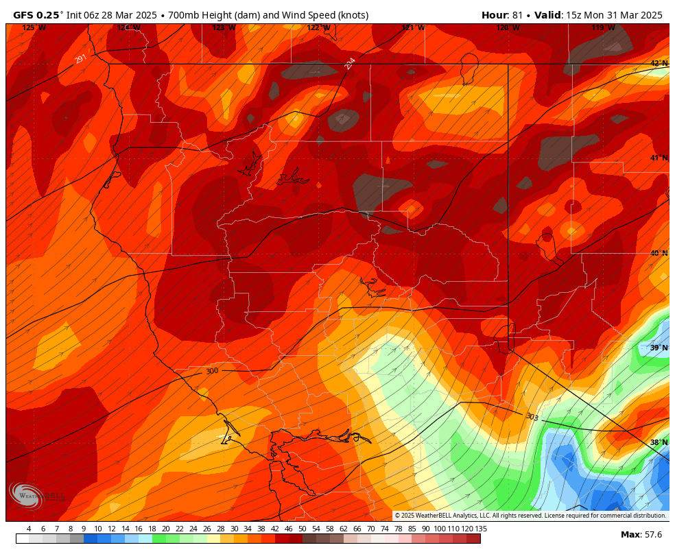
Bottom Line: There will be a strong wave on Monday with high winds. There will be lighter snow intensity Monday night into Tuesday with decreasing winds. New openings might be prime. Storm ski on Monday and take the latest openings on Tuesday. Timing with additional snow is still in flux, with a break possibly in midweek followed by additional pow later in the week. Snow quality will be somewhat dense on Monday with 10K temps in the -6 to -7C range.
Below: A cold front hits the Sierra and PNW later Monday, improving quality later in the day into Tuesday; however, moisture is decreasing. This cold front overspreads the Rockies on Tuesday. The PNW is colder by Monday morning.

Rockies, PNW
Below: Snowfall from Monday morning, March 31, to Thursday, April 3rd. Some impressive totals land in the Sierra, Oregon, central Idaho, Montana, Wasatch, Tetons, and eastern Wyoming (Laramie, Cheyenne). Colorado will also grab additional snow with possibly lighter totals (Wildcards). This will be a long-duration event with several waves next week. Tuesday-Wednesday might offer the deepest bumps in totals.

Below: The GFS model for Alta shows a slight bump of 7 inches this weekend (Warmer period), followed by a steady stream of Tuesday through Friday (Cooler phase). Two feet plus is possible in the Cottonwoods, with 9-15 in other areas of the Wasatch Range. Tuesday morning might be the deepest 12-hour total.

Below: Euro-GFS models- Vail Pass from March 30th to April 6th next week is in the 10-18 range when comparing multiple models. This might come over several days, but it will peak early next week and again mid or late next week.

Below: Jackson Hole Mountain Resort, with a range from 20 (European) to 40 inches (GFS), with vast differences. Our forecast is in the 15-22 inch range at this point (a Steady slug of moisture that adds up each day next week).

Below: Euro/GFS models—Big Sky Montana ensembles are very bullish on two peak periods of snow (Light to moderate Sunday), which will peak again by Tuesday. (18-24 inch totals are possible.)

Chases?
There will be a teaser storm this weekend (BC, PNW, MT, UT, CO, CA) with warmer temperatures. Colorado might overperform near the Front Range.
You might think about storm skiing the Sierra on Monday (Winds might keep upper lifts closed). New openings on Tuesday in CA might be prime with colder snow on top of the denser snow from Monday.
Oregon also looks to benefit on Monday. The Rockies peak Monday night into Tuesday (MT, WY, ID, UT, CO). Snow continues midweek, but the chase is unclear just yet. Overall, midweek totals in a wide area of the Rockies will be high. The highest totals might fall from southern Montana, western Idaho, Wasatch, Tetons, and northern and central Colorado.
Quality will be high with the colder temps!
DONATE FOR POWDER to support us.
NOTE: Please support Powderchasers with a donation, merchandise purchase(such as a hat or stickers), or sign up for our custom Concierge Powder Forecast Package, where we provide 1:1 phone & email support to get you to the deepest locations possible. When chasing snow, the Concierge gets you the very best intel. Sign up for our free email list so you never miss a powder day. Phone support is also available now.
New Concierge Program Guarantee or the Chase is free!


