
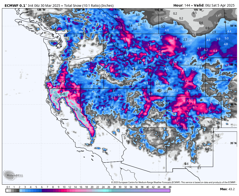
SUMMARY
A potent storm system is hammering the Sierra with heavy snowfall (and occasionally low snow ratios), then shifting inland with moderate accumulations and colder, fluffier snow across Utah and parts of Colorado. The biggest totals land in California’s Tahoe region, with several resorts pushing well over three feet by midweek, though expect strong winds and briefly rising snow levels. Elsewhere, Utah sees solid high-ratio powder, and Colorado picks up more modest totals but in colder, drier conditions. Bottom line: The Sierra delivers the biggest dumps, especially Monday into Tuesday, while Utah also scores excellent quality through midweek.
CHASE FORECAST
Monday (3/31)
Sierra First Light
-
Heaviest Overnight + Day Snow in Tahoe resorts like Palisades, Kirkwood, Sugar Bowl: around 10–15 inches by Monday afternoon (combined Sunday night + Monday day). Snow levels start around 5,000–6,500 feet, so expect dense snow at lower elevations. Strong ridgetop winds (potentially 100 mph gusts) could limit lift ops.
Tuesday (4/1)
The Prime Chase Window
-
Tahoe Keeps Piling It On: Another 10–18 inches possible at Kirkwood and Palisades from Monday night + Tuesday (SLR climbs into double digits, meaning fluffier turns on top of a dense base). If the wind cooperates, it’ll be deep, surfy riding.
-
Utah Goes Blower: Alta/Snowbird could see a solid 6–13 inches through Monday night + Tuesday, with SLR pushing 12–16+ for legit blower pow. Winds are strong but not as extreme as Tahoe’s—if the Sierra is socked in by wind holds, the Cottonwoods might deliver the day’s best riding.
-
Colorado Warming Up: Light to moderate totals begin Monday night, but most mountains (Vail, Breck, etc.) stay in the 4–6 inch range by Tuesday afternoon, so not a must-chase unless you’re local.
Wednesday (4/2)
-
Lingering Fresh in the Sierra: Some spots (Kirkwood, Sugar Bowl) snag another 4–7 inches from Tuesday night + Wednesday. Wind speeds drop, so conditions could be primo on smooth, fresh refills.
-
Wasatch Leftovers: Another 3–4 inches possible in the Cottonwoods Tuesday night + Wednesday morning. Not huge, but high SLR can still provide soft laps.
(If you’re looking beyond Wednesday, new storms in Colorado and scattered snow in the Northern Rockies/PNW might become chase-worthy later in the week—but the biggest show is definitely early to midweek.)
KEY POINTS
-
Good:
-
Sierra rakes in massive totals (especially Mon–Tue) as SLR climbs mid-storm.
-
Utah’s cooler air boosts snow quality, delivering blower pow Mon night–Tue.
-
-
Bad:
-
Initial low SLR (dense snow) in parts of Tahoe, plus high winds Monday could hamper lift operations.
-
Rising snow levels in the Sierra on Sunday might turn lower-mountain terrain to rain.
-
-
Wildcards:
-
Scattered thunderstorms in the Sierra and parts of Idaho/Utah could bump snow totals or bring brief, intense bursts.
-
Storm track uncertainties in Colorado’s late-week system could shift bullseyes last minute.
-
REGION-BY-REGION DETAILS
California (Sierra Nevada)

A powerhouse storm charges in Sunday morning, with snow levels initially near 5,000–6,500 feet then climbing to around 7,000 feet in Tahoe by afternoon. Expect dense, wet snow or even rain at lower elevations Sunday. The real action arrives Sunday night through Monday, when snowfall rates crank up to 1–2" per hour. Resorts like Kirkwood, Palisades, Sugar Bowl, and Northstar can see 1+ foot by Monday night.
Monday into Tuesday features the storm’s peak intensity, dropping another 1–2 feet at the upper elevations with SLR climbing into double digits—so heavier base layers topped by fluffier new snow. Watch for extreme ridgetop winds, potentially gusting over 100 mph, especially on Monday. Travel over high passes will be challenging. Snow tapers Tuesday night into Wednesday, but a final round of lighter accumulations (up to half a foot) keeps surfaces refreshed. Overall, a classic Sierra storm cycle: big dumps, heavy first, then sweetening with colder air late.
Utah

Snow showers kick off Sunday in the high terrain, but main event arrives Monday night into Tuesday as a strong cold front drops snow levels to the valleys. Expect 6–10" across the Wasatch with higher pockets (up to 13") in upper Cottonwood Canyon resorts (Alta/Snowbird, Brighton, Solitude). SLR climbs into the teens, so once the wind calms, it’s proper blower. Winds from the southwest could hit 45+ mph in exposed areas Monday, but Tuesday morning riding looks excellent. By Wednesday, lingering showers in the northern mountains add a few more inches. Temperatures run 10–20°F below normal midweek, preserving snow quality nicely.
Colorado

An initial burst of snow arrives Monday night, mainly along and west of the Continental Divide (Steamboat, Vail, Summit County). Totals in the 4–8" range by Tuesday evening are common, with the higher end near the Park Range (Steamboat) under a Winter Storm Watch. Some passes could get hammered Tuesday–Wednesday with moderate accumulations (another 4–8"). SLR generally runs quite high (11–17), meaning drier snow. Strong southwest surface winds might affect travel in the valleys, but mountain lifts should be less impacted aside from potential blowing snow. Additional late-week disturbances could bring more snow, especially around Wolf Creek and southern mountains.
Northern Rockies

Off-and-on storminess spans from Sunday into midweek. Wyoming (Jackson Hole, Targhee) sees smaller daily accumulations (1–5" each day), though Targhee’s SLR often creeps into the 13–15 range for delightful fluff. Idaho’s higher spots (e.g., Sawtooths, Brundage, Sun Valley) get moderate pulses Monday–Tuesday—up to around 6–10" total—accompanied by breezy conditions. Montana resorts (Big Sky, Bridger, Whitefish) pick up scattered hits of snow Monday through Wednesday, with some spots seeing around 6–12" total over multiple days. Nothing monstrous, but cold air keeps quality high.
Pacific Northwest

A series of weaker disturbances push moisture across Washington and Oregon. Mt. Bachelor could tally around 1–2 feet total by Thursday, especially from Sunday night through Tuesday, with reasonably high SLR near 10–13. Breezy winds in the Oregon Cascades are likely Monday. Washington Cascades (Crystal, Stevens, Snoqualmie) see modest accumulations—4–8" in pockets through midweek. Snow levels will hover around 2,500–4,000 feet, occasionally dipping lower after each frontal passage. By late week, ridging brings a warmer, drier trend across the PNW, setting up classic spring conditions heading into the weekend.
EXTENDED OUTLOOK
A drying and warming trend takes over most of the West by late week into the weekend, bringing sunny skies and spring-like temps—especially in the PNW and Northern Rockies. There’s still some hint of additional energy diving into Colorado and the Southwest late in the week, so keep an eye out if you’re chasing southern storms. Otherwise, plan on sunshine and softening snow surfaces next weekend for much of the Rockies and the West Coast.
DONATE FOR POWDER to support us.
NOTE: Please support Powderchasers with a donation, merchandise purchase(such as a hat or stickers), or sign up for our custom Concierge Powder Forecast Package, where we provide 1:1 phone & email support to get you to the deepest locations possible. When chasing snow, the Concierge gets you the very best intel. Sign up for our free email list so you never miss a powder day. Phone support is also available now.
New Concierge Program Guarantee or the Chase is free!


