Just when we pushed winter 20/21 aside, it is going to roar back with a vengeance this week, especially in central Montana where up to 12-20 inches are likely in the central portions of the State. Snow is currently falling in the higher peaks of the Cascades of Washington and Oregon as of Thursday morning. The Sierra will see light snow Thursday night with temps dropping low enough for some white to return to lake level, however primarily on the grassy surfaces or highest mountain passes. A winter advisory has been issued for the northern Lake Tahoe area. The highest snow totals will come over Montana and even the lower elevations primarily Thursday to Friday. The possibility of heavy snow totals may result from a stalled low pressure system over the Nevada/Utah border pumping moisture into Montana spreading south albeit lighter amounts towards Yellowstone. Even the Tetons might grab some light snow at upper elevations from this storm late this week into Monday (Highest peaks only). As of Thursday morning looking at automated snow-water telemetry a foot of snow has already fallen at the Mount Lockhart site at 6400 feet (Near Teton Pass).
Below: Stevens Pass Ski area Thursday morning.

Below: Lost Trail Pass- Idaho Thursday morning

Below: Deep Low Pressure Trough swinging down from the PNW primarily pushing moisture into the northern Rockies to as far south as the Sierra (Light snow and cooler temps above 9500) late this week. The highest impacts from this storm will be in Montana.

Below: The most bullish model once again being the American GFS showing pretty hefty snow totals for Montana through Friday. The highest impacts will come over the central mountains including Lewis and Clark Counties late Wednesday to Friday. Snow will also be falling over the eastern regions of Glacier National Park as well as south towards Yellowstone albeit lighter amounts. Ski areas located over central Montana such as Teton Pass, Great Divide, and Showdown would all be ones to watch (All closed) for some fresh snowfall. 12-20 inches are possible along the eastern side of the Divide especially close to Teton Pass Ski area in Montana north of Helena.

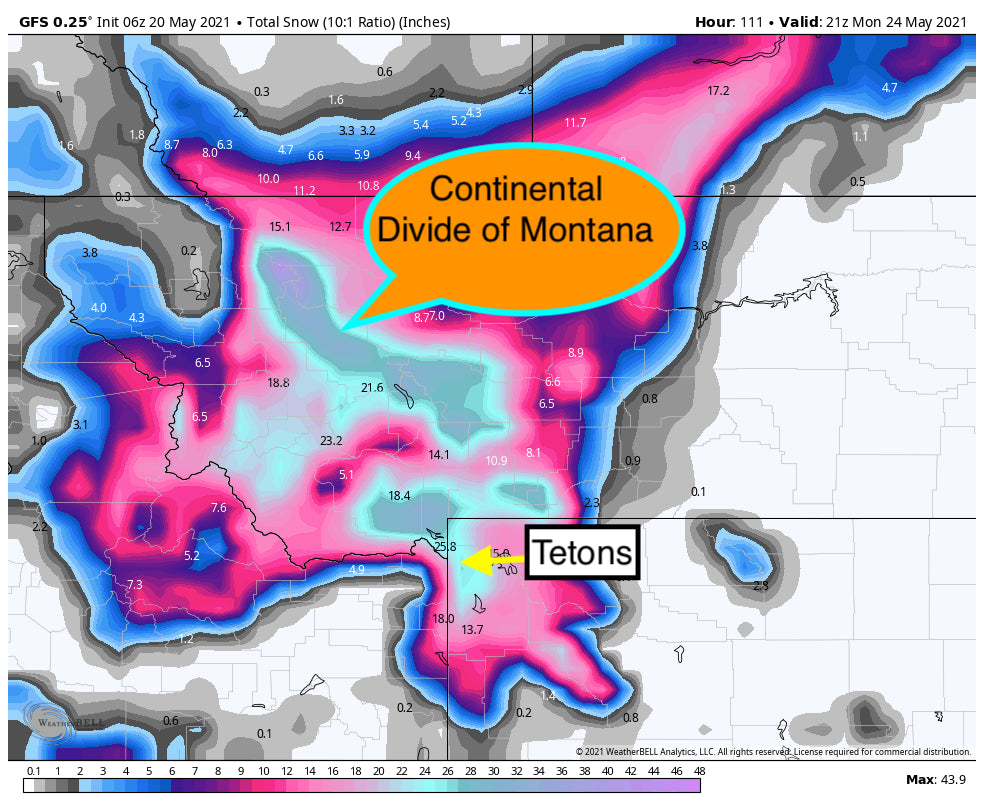
Below: Looking out through Monday some models show significant snow dropping south into the higher elevations of the Tetons and even southern Montana late this weekend. Others continue to focus snow over north central Montana. High confidence for significant snow to continue in the north central regions of Montana with some minor confidence of moderate snow at the highest peaks of Big Sky, Yellowstone and the Tetons. Its unlikely we will see lowland snowfall in these areas. Some light snow is also possible for northern Utah late Sunday or Monday. This is the most bullish model for significant snow as far south as the Tetons where others show much less (Above 9500 feet).

Below: Looking at temps for Montana they will be below freezing as low as 4800 feet later this week with warmer conditions over Wyoming.

Below: The National Weather Service Forecast Homepage looks a bit more like Winter versus late May.

Below: The Sierra sees widespread light snow Thursday night into Friday morning above 6500 feet.

Please follow us on Facebook and Instagram (@powderchasers) for the latest updates. Our loyal following has grown significantly in the past several years. We appreciate the reader submitted content so keep those photos coming in our direction (via social media or our email) If you want to support powderchasers forecasts please submit a donation here. That keeps us cranking out powder news!
Powderchaser Steve @powderchasersteve via instagram @powderchasers


