Summary:
Significant Pow for the Sierra (Game-changing) with leftovers aimed at many spots in the northern Rockies. If you're in Arizona right now good luck getting to Arizona Snowbowl with major road closures and 30 inches of blower.
Forecast:
As of 6 AM, most major roads into Flagstaff are currently closed. 30 inches has fallen in 24 hours with 20 overnight. Got a call this morning at 5:30 AM \I've been driving all night from Phoenix and have been on closed roads since midnight\". There is nothing worse than looking at a snow report with 30 inches and not being able to get there! Below: Snow report from AZ Snowbowl Tuesday morning. If you are there or stuck in traffic please comment on this post.

The next week brings several chase opportunities. Obviously, the Sierra is going to go off big time from late Tuesday night to Friday. High confidence of 4-6 feet above 7,000 feet. This will impact the entire range from Mammoth to Squaw and north towards the Oregon border. Much needed moisture (Up to 7 inches) is going to be a game-changer for California resorts.
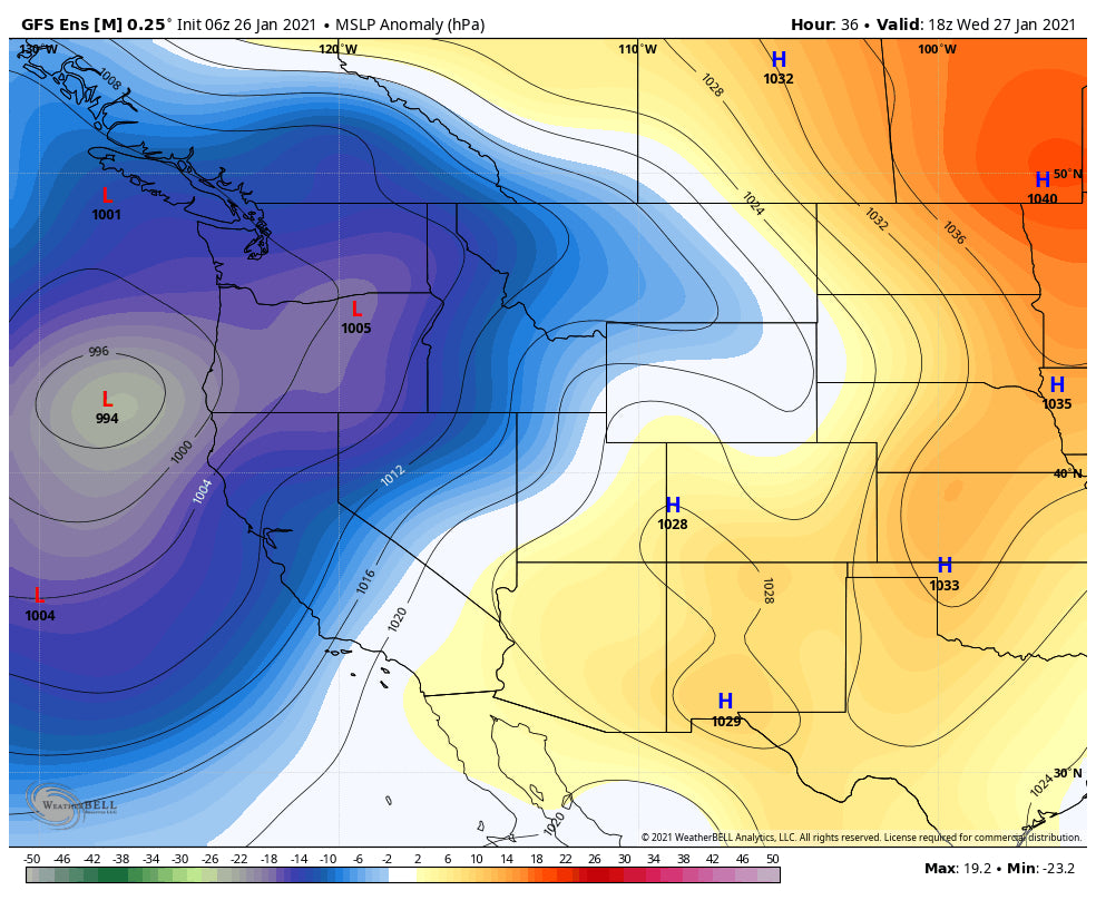
Below: Low pressure entering the west coast on Wednesday morning impacting many areas of the west coast from CA, OR, and WA. This will eventually weaken and spill east over Idaho, Wyoming, Utah, and Colorado.

Below: Current snowpack for the Sierra range (% of water equivalent if you melted the current snow). The Truckee basin is sitting from at 53%. We really need several large storms to bump those numbers up considerably.

The Chase: Snow is still falling in Arizona and will continue albeit lighter for southern Colorado on Tuesday. Side Note: We mentioned some remnants from the 4 corners making their way into the Front Range Monday night. Generally, only 1-4 inches fell with Breck at 4 inches Tuesday morning. Telemetry (Unofficial) at Wolf Creek appears to be at an additional 3-6 inches overnight.
The Sierra will see multiple deep 12-16 inch powder days Wednesday to Friday. Strong ridgetop winds will keep most upper elevation terrain closed (My guess- Unofficial). S or SW wind will be gusting to over 100 MPH at times. There is a break late Friday AM before a weak additional wave enters for Saturday. Friday or Saturday are likely candidates for rope drops. Total snowfall through Friday afternoon is likely to be 4-6 feet above 7,000 feet. Stick with lower elevation less wind prone resorts.
Below: Sustained winds at 10K feet for the Sierra (Upper Crest) at 60MPH on Wednesday morning. Gusts will be much higher.

Pieces of energy from the Sierra storm shunt north into Washington State impacting the Eastern Cascades on Wednesday/Thursday. Amounts could be respectable (Mission Ridge, North Cascade Heli). Look for a sneak up moderate powder day here. Energy will also spill light to moderate snow for most of the Oregon resorts.
Moisture from the Sierra under S, SW flow pushes into Idaho and Wyoming Thursday-Saturday. The Sawtooths are favored in this pattern with perhaps 12-18 inches of snow above 7,000 feet. Lower elevations will see less snow with a warming trend on Friday. Most model runs are in good agreement for snowfall for south/central Idaho. The Tetons offer a mixed solution of model runs. The American GFS shows light continuous snowfall from Wednesday PM to Saturday AM with a peak during Thursday night or Friday. This could add up to 12-16 inches by the weekend. The European model is more pessimistic with several 2-4 inch events nearly every day perhaps adding up to 10 inches by Friday night. look for multiple soft days with new snow on the report at both JHMR and Targhee this week. JHMR is favored in this wind direction (S or SW). The sum totals will be decent.
Caveat: Warming will occur late this week in both Idaho and Wyoming. Quality might deteriorate at lower elevations.
For Utah, the American GFS model shows a sneak up powder day for Thursday (3-7) where others show much less. Light snow will be falling over northern Utah from Wednesday to Thursday with the chance of a pretty decent day in the latter period. Saturday would be your best pick (Ugg another weekend storm, but does it really make any difference anymore).
Extended:
Models continue the chances of snow for Utah on Saturday. The GFS favored the Ogden Valley (Snowbasin can do well in this pattern) with perhaps another 4-8 inches in spots for the early AM lifts. It's too far out to forecast with certainty.
Finally, Colorado will stand a chance of some moderate snow for the I-70 corridor into Summit County for Saturday. Higher amounts are possible near Aspen or spots further south in the San Juan Range (broken record). I have decent confidence for this storm to perform better for the northern areas than the previous ones that have nearly skunked many areas. While it's not a huge event, it will be a nice freshening.
The weekend may also return some pow to the PNW that eventually works into the Sierra for another decent storm by Tuesday. That is likely to track south once again over the 4 corners (Too far out to forecast).
Follow me on Instagram @powderchasersteve (Travel, Powder, Adventure). And follow our other forecaster and rider Luke @lstone84.
Please consider a donation to Powderchasers to support our forecasts or join our custom concierge chase program.
Enjoy the powder everyone! Chase wisely! Lots of red flags this week but if you score an opening with deep snow I guess it was worth the wait!
Powderchaser Steve


