An active storm pattern is taking shape across the West this week, starting with a pulse of rain for the PNW and then diving south, bringing fresh snow to the mountains of California, Idaho, Wyoming, Utah, and Colorado. Snow levels and totals will vary widely, with wetter, heavier snow across the board as snow levels fluctuate throughout the storms. While the first storm hits hard, a second one follows, keeping the powder train rolling.
NOTE: Sunday is the final day to purchase the Indy Pass. Indy Pass limits the number of passes sold to balance resort capacity and passholders in each region. This strategy eliminates the risk of overselling passes and creating chronic crowding issues seen on other passes. Get yours before it's too late!
CANADA will likely be the winners next week with over 100 cm (39 inches) noted on the models from Sunday night to Wednesday. Areas of western BC will see the highest totals (Mid and upper mountain) with slightly lower but respectable totals noted for the interior. Whistler will likely see 25-35" at mid-mountain. Revelstoke will see slightly lower totals, likely 20-30".
Below: Total snowfall in BC and areas of the PNW early to mid next week November 11-13. 2-3 feet of snow is likely for many areas.

Pacific Northwest
The first taste of this weather system arrives with a brief spell of rain on Saturday from morning through the evening, mainly affecting the PNW. Snow levels start high, around 7,500 feet, before dipping to around 6,000 feet on the tail end of the little system, but most resorts will see rain rather than snow during this prelude. Check out sparse precip amounts from the ECMWF below:

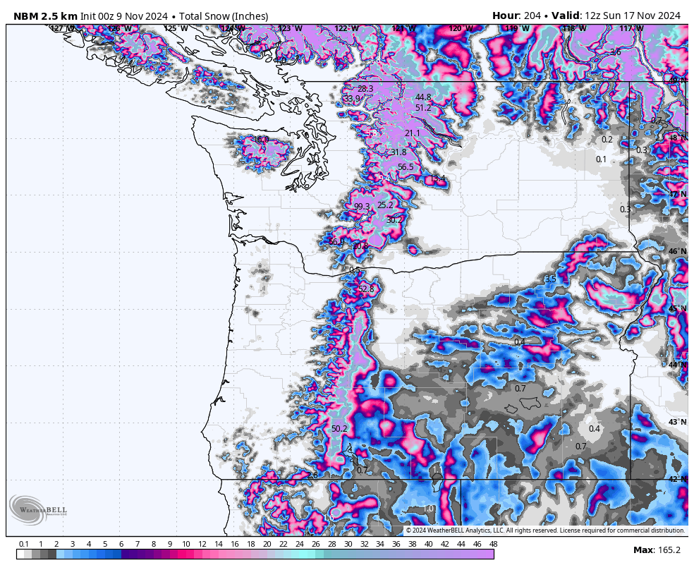
The main storm starts Sunday afternoon and continues through Tuesday night, with snow levels ranging between 4,000 and 6,500 feet. A second storm promptly follows, hitting Tuesday night and persisting into Thursday/Friday, with slightly lower snow levels than its predecessor. Current model runs are suggesting pretty solid snowfall totals at mid-mountain elevations. However, keep in mind that small changes in the rain-snow boundary could greatly influence amounts. Snow will generally be on the heavier side due to warmer temperatures, so powder quality will be on the lower side. Here are totals from Monday AM through Saturday (November 11-16):
- Mt. Baker: 20-30" (12-24" at the base)
- Stevens Pass: 15-20”
- Alpental: 4-8” (mostly rain)
- Crystal Mountain: 18-22”
- Timberline: 30-50”
- Mount Bachelor: 22-34”
Below: Low snow levels in the PNW (3-3500) early next week with slight warming noted on the models by Wednesday November 13th at the tail end of this GIF.

Below is the ECMWF (left) and GFS (right) forecasts for all storms combined into Friday. The GFS feels a little bullish here, I'd lean towards the slightly more conservative ECMWF forecast:

California

As the storm descends southward, California will see snowfall late Monday afternoon. This is a very fast system, with precipitation wrapping up in Tahoe by early Tuesday morning. Snow levels in Tahoe will start around 7,000 feet before dropping below 5,500 feet at the tail end. Mammoth sees similar trends, though snow levels may remain a bit higher there. Snowfall totals will generally lean on the wetter side here as well:
- West Shore (Sugar Bowl, Palisades, Kirkwood): 3-6”
- Central Tahoe (Northstar, Homewood): 1-4”
- East Tahoe (Mt. Rose, Heavenly): 2-5”
- Mammoth: 1-3”
Utah
The storm sort of breaks up before bringing anything meaningful to Utah. Residual moisture filters into Utah by Tuesday morning, with snowfall lingering into the evening. Expect 4-8 inches in the Cottonwoods and 3-5 inches for Park City/Deer Valley, with lower totals further north.
Colorado
Same story as Utah; light snowfall reaches Colorado on Tuesday evening, wrapping up by early Wednesday. Accumulations will be light, with 0-2 inches favoring the northwest mountains and minimal snow for the San Juans.
Idaho & Wyoming
These regions will also be under the influence of this active pattern, with 5-20 inches expected across many mountain areas. Schweitzer will receive the heaviest snow, starting early Monday afternoon and lasting until Friday evening. The Selkirk Powder Guides area just north of Schweitzer will likely see even more. By Sunday, we anticipate the following accumulations:
- Schweitzer/Selkirk Powder Guides: 25-35”
- Sun Valley: 3-9”
- Big Sky: 8-18”
- Grand Targhee: 11-17”
- Jackson Hole: 8-16”
Looking Ahead
A fresh storm is on the horizon for Friday, targeting Oregon and California, and it looks to be setting up further south than the current systems. Details are still uncertain, but we’ll be keeping an eye on developments. Stay tuned for updates as the week progresses!
Please support Powderchasers with a donation, Merch purchase, or sign up for our custom Concierge Powder Forecast Package where we provide 1:1 phone and email support to keep you in the deepest locations possible. Outside Magazine listed Powderchasers as in the top 3 sites with the custom concierge program. This supports us and keeps you chasing the deepest snow all winter. It is time to start trip planning and chasing pow!


