Snow showers broke out on Tuesday and continued into Wednesday morning with very cold unstable air in the Rockies. Generally, snow totals range from 3-10 inches on Wednesday morning.
Grand Targhee: 5-9 inches
Steamboat: 9-10 inches
Alta: 6-8 inches
Breckenridge 5-6 inches
Below: Aspen Mountain picked up 5 inches on Tuesday PM (Left side is new snow)

Below: Breckenridge on Wednesday morning (That is on top of 15 that fell earlier this week).

Below: Snow is falling on the Divide and east Wednesday morning into the Front Range Metro areas.

Below: NW winds and colder temps often do well with the Boat.This brought 9-10 inches to mid mountain. Very little snow was noted at the summit cam.

Forecast:
Low pressure that skirted over the northern and central Rockies Tuesday is headed into the 4 corners for Wednesday-Friday.
This low will cut off (Stall) and will provide very significant snowfall to some areas of the northern and central mountains of New Mexico, Southeastern ranges of the Colorado San Juan Range, eastern plains of Colorado, and perhaps moderate snow further north into the central mountains of Colorado (Wildcard).
Southern Low pressure systems are often very difficult to forecast and especially cut off lows that often determine a very narrow line of significant snowfall (Versus a broader open trough that impacts wider areas). At this point, our forecast is going to favor the eastern San Juan Range of Colorado (Wolf Creek wildcard), and extend into most of northern New Mexico. Some areas of New Mexico could pick up 20-30 inches of powder through Friday. The highest totals might land on the eastern favored resorts such as Angel Fire, Ski Santa Fe and Pajarita. Taos will also pick up significant totals but likely less.
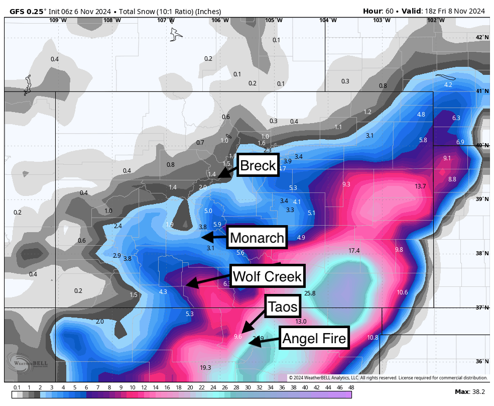
Below: The American Model is the furthest east and south with less snow in central or western Colorado (Wolf Creek is wildcard). This is snow from Wednesday night to Friday morning and favors the eastern flanks of the mountain ranges especially SE Colorado and northern New Mexico.

Below: The Short Term NAM (Slightly higher confidence) has snow a bit further west and north. This model agrees most with the European model.

Below: SE and Easterly winds noted for Colorado and New Mexico (Bottom of map) with this storm. These winds favor eastern areas of most of the mountain ranges such as Cuchara, Angel Fire, Pajarito, and even Ski Santa Fe. Taos can sometimes perform well also, but will likely report slightly lower totals.

Bottom Line: As the low cuts off in the 4 corners, I have high confidence in 20-30 inches of snowfall for areas of New Mexico favoring resorts that do well with SE or easterly flow (Angel Fire, Pajarito, Ski Santa Fe). Taos might come up a bit short with 9-17 inches. I have moderate confidence in 7-12 inches extending into Wolf Creek, however, higher totals might be found on the eastern side of the Pass versus the ski area.
Monarch is a contender also sitting in the central mountains, however does best with NW or W winds versus SE or East (Good for Salida). Less snow will fall along or north of I-70 (High confidence). Front Range areas south of Denver along I-25 could get deep especially east of I-25. There is significant model differences. Some show heavy snowfall into areas from DIA and east. Our forecasts believe the main impacts will be south of Denver and east of I-25.
Sponsor Alert: Coupon Code POWCHASE gives you 15% off your Purl Wax orders. Purl make the best ski/snowboard wax! Powderchasers is also looking for a few more sponsors for our posts and homepage. If you are looking for exposure to your winter related product, ski area, or Heli/Cat ski operation please reach out to us at info@powderchasers.com.
EXTENDED POWDER- Keep reading!
Another strong low-pressure system is likely to impact much of Canada, the Pacific Northwest, and perhaps the Sierra early to mid-next week (November 11-14). This will likely dig further south than the last storm and impact a wide area of the west as an open trough (Good for many ski areas).
Below: 3-day snowfall ending Thursday morning (November 14) per the GFS. This impacts a wide area of the west including the Sierra. WOO HOO.

Below: European solution: (Slightly less digging south and deeper up north). This would result in less snow for the Sierra as compared to the GFS above.

Below: Ensembles from the University of Utah showing 10-30 inches of snow possible for Mt Baker next week (November 10-15). These tend to be overdone but confidence is high in a significant storm for the Cascades of Washington and Oregon. LetLetss hope it digs south into the Sierra.

Below: Ensembles for Jackson Hole Summit next week November 12-14. (5-15 inches).

Below: Ensembles for the base of Palisades have less confidence with ranges from 5-10 inches. This could change with lower confidence this far out.

Powderchaser Steve @powderchasersteve via Instagram


