Very wet conditions will continue this week for Canada and the PNW. 2 systems will drop south into the Sierra as they weaken, and spread north into Idaho grazing the Rockies. Flip flopping snow levels will keep 2-3 foot snow totals confined to upper elevations. The following week (Day 7) could be deeper and colder for much of the west including the Rockies.
Powderchasers just hit 100K followers on Instagram. This is a milestone for us, and we want to thank everyone that follows our daily posts, chases, and weather. @powderchasers on Instagram and Facebook. Both social platforms offer different content.
In terms of chasing powder, the temperatures in the PNW, which are flip-flopping from warm Monday to cool Tuesday and warmer Wednesday, would have us wait for the colder air later this week. Next week, the PNW will see colder and snowier conditions (November 17-18).
Below: Whistler at 6,000 feet is getting significant wet snow on Monday morning and should continue into midweek. Amounts might exceed 9-15 inches at mid-mountain and 30 inches at the summit.

Below: Heavy wet flakes on the snow camera at 5400 feet Monday morning.

Below: Total snowfall for the PNW through Monday night is filling in for much of the Cascades of Washington and Oregon, but unfortunately, the snow levels are nearly 5,000 feet (Rain at the bases initially). Three inches were noted at Crystal mid-mountain Monday morning. Mt Baker is favored in this pattern with SW flow, so it is possible that the summit is picking up wet base-building snow (Rain at the base and perhaps mid). MAP: Monday morning to midnight.

Below: Crystal Mountain Base Monday morning. Once cooler temperatures move in Monday PM and Tuesday, it will likely change back to snow.

Below: Warm air will erode by midday or later Monday into Tuesday and bring the snow levels down to near 3500 feet. This will bring some light to moderate snow to the bases of most of the ski areas by Tuesday. Map: Monday morning to Tuesday midday at 4800 feet in Celsius in the PNW.

Below: Total snowfall for western Canada and the PNW exceeding 30 inches by Thursday (November 14) at the upper elevations (Likely above 5,000 feet). The most optimism in SW flow is the summit of Whistler. Moderate totals are likely further south in Washington from Mt Baker to Crystal, where 7-15 inches will fall above 4500 feet. SW winds often favor the northern Cascades near Baker, with the models below being a bit over-bullish for some areas on this map.
Snow levels drop from Monday PM to Tuesday. Unfortunately, snow levels rise again on Wednesday (5000 feet), bringing rain back to most bases of the Cascades. Snow totals will be very elevation-dependent.
Total snowfall in the PNW by Thursday In the PNW ending November 14.
Whistler: 15-30 Mid to summit
Baker: 7-20- Base to Summit
Stevens Pass: 9-15 Mid to summit
Crystal: 11-18 Base to summit.
Selkirk Powder Guides (Idaho) 14-20 Mid to summit
Bachelor: 8-16 Mid to summit
Timberline: 8-16 Mid to summit.

Sponsor Alert: Selkirk Powder located north of Schweitzer Ski area is likely going to grab deep freshies from this storm. Please check out their homepage for upcoming AVY class dates and guided cat skiing in their new 6200 acre area.
SIERRA SNOW
Below: Snow spreads south into the Sierra from Monday evening to Tuesday, with leftovers in the 3-7 inch range.

ROCKIES
Below: Weak leftovers from the Sierra will overspread the Rockies (Tetons, Central Idaho, Wasatch, and North/Central Colorado by Tuesday. A second moisture surge hits the PNW by Wednesday/Thursday (Warm air cooling by Thursday) and takes a similar path into the Sierra with light to moderate snow. That system will deliver a slightly more potent punch to the Rockies, with moderate snow for western Idaho decaying as it moves east.
Extended forecast (Mid week to the weekend November 16)
Map: 24-hour snowfall totals from Wednesday to Friday night. PNW gets another strong push of moisture, taking a southerly route over the Sierra and north into Idaho. The Tetons might see some moderate snow with less over the Wasatch and into Colorado.

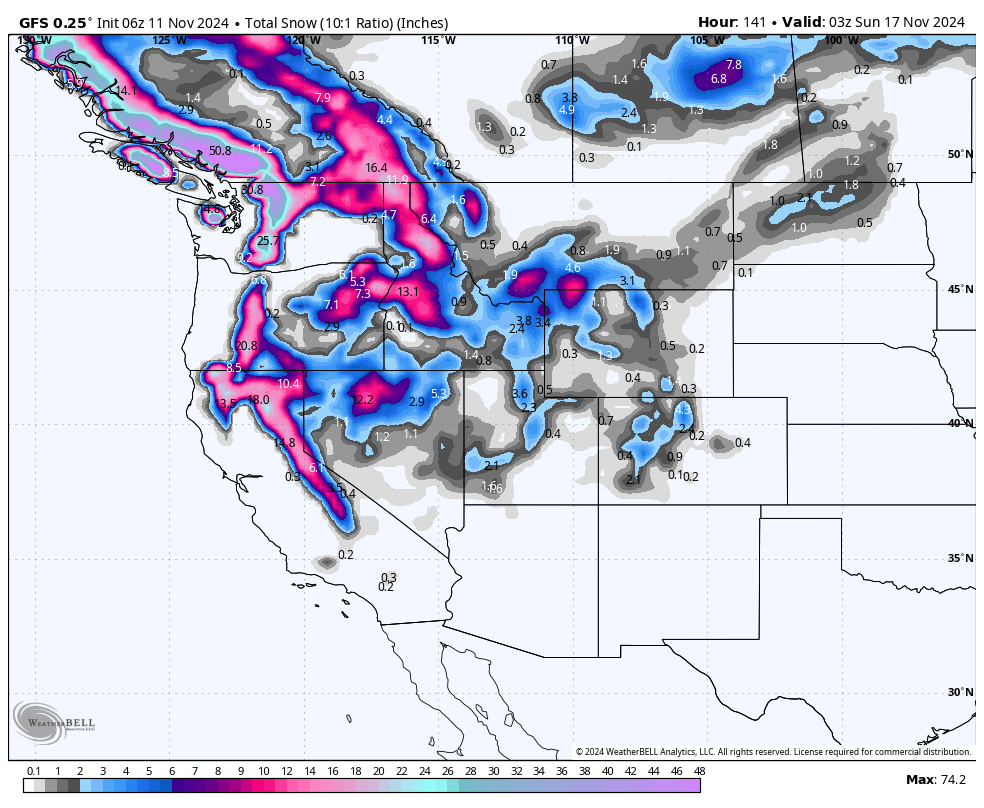
Below: Total 6 day snowfall at 10:1 ratios for the west through Saturday night, November 17. The most significant totals are in the PNW, including Idaho, followed by the Sierra and northern Rockies. These totals are the combination of 2 systems.

Below: Another robust system with colder air is likely by late this weekend (November 17) into early the following week. This might bring some decent-quality powder to the PNW. The current track looks a bit similar to the last system, pushing south over the four corners and spreading significant snow into New Mexico and Colorado. This is too far out to forecast with accuracy!
Bottom Line: Active pattern. No blocking high pressure. Lots of November Moisture. Great base-building snowfall.

Please support Powderchasers with a donation, Merch purchase, or sign up for our custom Concierge Powder Forecast Package where we provide 1:1 phone and email support to keep you in the deepest locations possible. Outside Magazine listed Powderchasers as in the top 3 sites with the custom concierge program. This supports us and keeps you chasing the deepest snow all winter. It is time to start trip planning and chasing pow!
Powderchaser Steve


