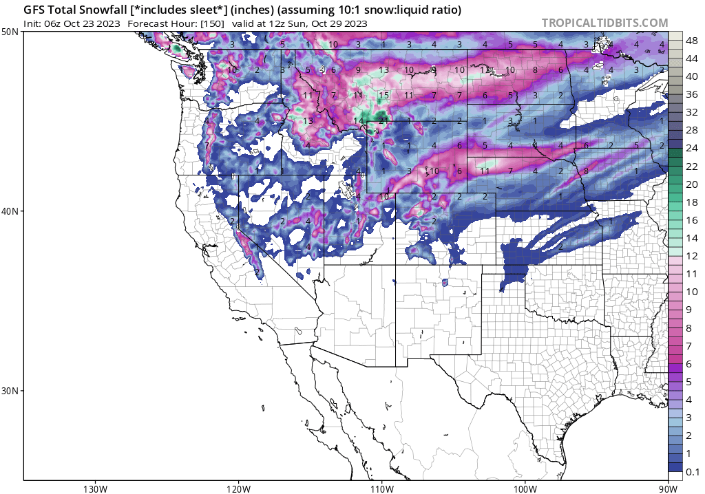
EPIC amounts of snowfall are a certainty for many areas of the West. The weather models are coming into Synch for an excess of 12-18 inches for the northern Cascades, 20 plus inches for some mountain peaks in Montana and Wyoming, with Idaho not far behind. Utah is a bit of a wildcard with the coldest temps further north, however 1 model still shows decent totals (5-10). Colorado and the Sierra get their best chances late this weekend with a second surge of cold air and powder Saturday to late Sunday. Everyone wins in the next 7 days.
Announcement: Get your snow tires on now. Tire Rack has many promotions currently and supports Powderchasers. You can order today and have them delivered to your door or a Discount Tire Store in 24 hours. There are some promos on winter rated All Seasons with $100 off. Click here to explore Tire Rack.
The top spots to score very deep snow midweek will likely be a large area of central and south-central Montana, Northern Wyoming, and the Cascade Ranges, especially along or north of I-90, Mt Baker, and perhaps Mission Ridge.
Below: 7 day moisture totals are plentiful (2 inches plus) through many areas of the west. The Majority of moisture will fall mid to late week for the PNW and northern Rockies with the Sierra, Utah and Colorado trying to play catch up for the weekend.

Below: The PNW will be deep by Wednesday morning, especially northern areas. Snow levels plunge to near 2,000 feet. Some lowland snow is possible outside Seattle in the hills (Grassy areas). Mountain passes will be treacherous for drivers. Get your snow tires on now! In Canada the highest odds of seeing double digits will be southern Alberta, and Interior BC (Southern Regions).

Below: Snow is filling into the Idaho, Montana and Wyoming by Wednesday morning continuing into Thursday. Utah grabs leftovers later Wednesday or early Thursday. The Sierra gets teased with light snow until it picks up for the weekend.

Below: Very impressive snow totals (12-25 inches) are noted in Montana and northern Wyoming. Utah could still see 5-10 inches favoring the northern Wasatch or perhaps BCC (SW flow) as a wildcard. Beaver Mountain near Logan might do well located up north. Idaho does well near the Montana border with Selkirk Powder a wildcard.

Below: University of Utah Ensembles showing decent confidence in a double digit storm for the Tetons (12-20 inches at the summits would not be a surprise).

Below: University of Utah ensembles showing even higher amounts for the upper elevations of Big Sky with high confidence (Tight Lines)

EXTENDED STORM #2
Cold air eventually moves into the Sierra Range and drags another front moves inland this weekend. Snowfall will likely increase in the Tahoe Basin with favorable odds of a moderate or perhaps double digit dump for the Wasatch Range in Utah and many areas of Colorado. Model data this far out will change, but we have hope that this will happen. See the maps below.
Below: Cold air is noted in the Tahoe Basin that will extend east over the Rockies for the upcoming weekend (October 29-30).

Below: 48 hour snowfall ending Sunday morning (October 30) landing some decent totals for a narrow area of the Sierra and central Rockies (2 day snowfall totals).
 Bottom Line Powder: Deep storm midweek, bitter cold temps favoring the PNW and northern Rockies. 2nd storm favors the Sierra and Central Rockies next weekend (Moderate or low end heavy event). The temps are more representative of mid-winter.
Please join our custom forecasting program on the "powder concierge" that allows us to steer you to the deepest storms all season. You can also support us with a donation here, or purchase some swag on our website.
Follow @powderchasersteve on Instagram for photography, bears, and snow.
Enjoy the pow everyone!
Powderchaser Steve.


