Powderchasers has been watching this very potent cold front due by the middle of next week for all of Canada and the majority of our Rocky Mountain Ranges. Over the past several days the American GFS has been bullish for a broad trough to rip south through Canada, the Pacific Northwest, and most of of Idaho, Wyoming, Montana, Utah, and Colorado. Other models are keeping the bulk of moisture over Canada, northern Washington, and Montana, with less snow spilling south over Wyoming, Utah, or Colorado. We are going to show you the different maps and solutions for next week. There should be a better consensus as we get closer but it's important to look at all the maps below. Someone is going to get nailed with several feet of powder!
Announcement: Powderchasers has teamed up with Skis.com
Skis.com & Snowboards.com are the go-to source for winter sports enthusiasts looking to elevate their game on the slopes. As a PowderChasers follower, enjoy 10% off one full-priced item of $125 or more at Skis.com! Use coupon code POWDER10 - expires 10/22/23 -exclusions may apply, see Skis.com/exc for details.

Below: Comparison of 2 models with the GFS on the left digging further south and a deeper low. The European on the right is further north.


Below: American GFS is bullish for a broad trough to push south from Canada (Interior BC and southern Alberta are favored in this solution) into much of the Pacific Northwest extending into most of the Rockies. We don't put high confidence in a single model, even though the GFS has been consistent over the past several days. This map is through Friday morning October 27th. Keep reading for other model solutions.

Below: The European model has drastic differences keeping even more significant pow over much of western Canada including Whistler, and most of the interior of BC and western Alberta. The northern Cascades of Washington are very deep if this scenario plays out. Moderate snowfall is noted for Montana and northern Idaho with less snow over the Tetons. Note: With colder temps snow totals will be higher due to better snow ratios than shown on this map (10:1) which is 10 inches of snow to 1 inch of water. Some spots could end up with several feet of powder by late next week with this solution.

Below: The Canadian model is the big pessimist showing snow mainly confined to Canada (Oh Canada) and less snow for the States. This leads us to believe that the GFS at the top is more of the outlying solution.

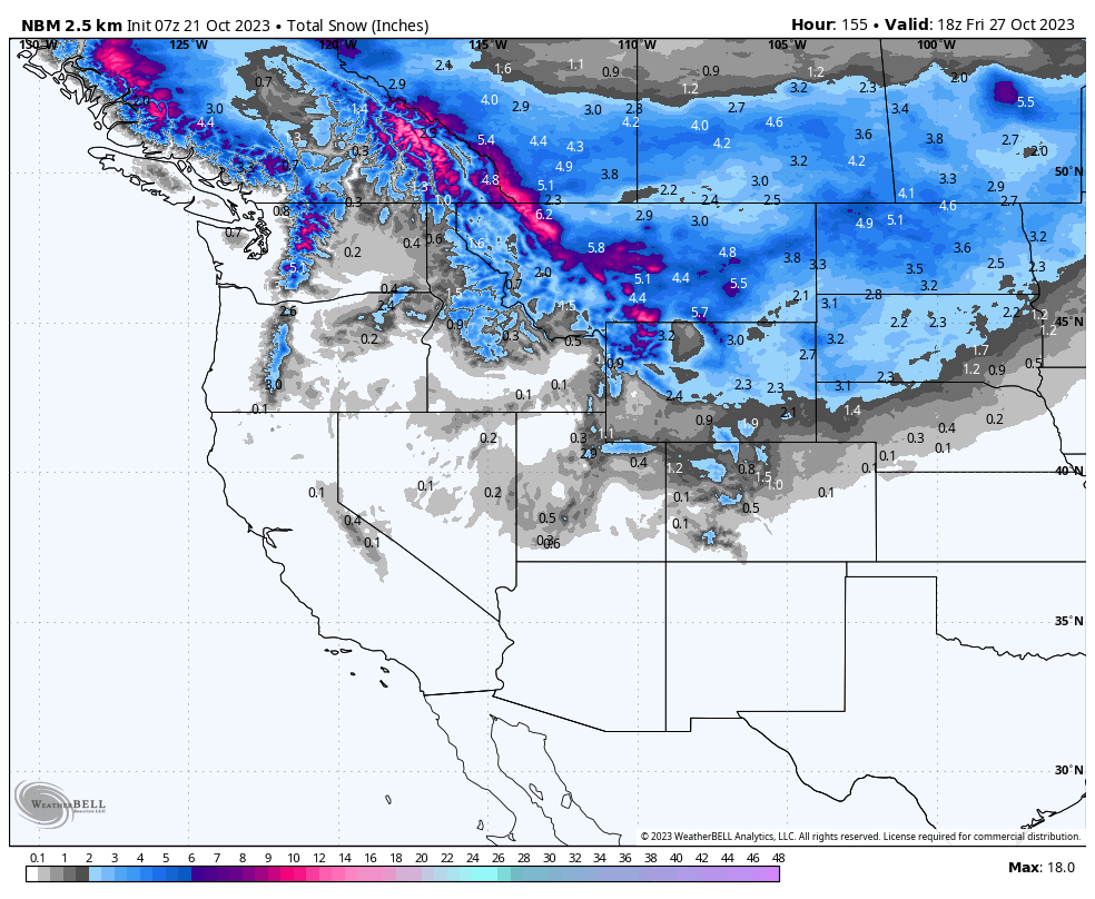
Below: Confidence might be best in looking at the National Blend of models with good optimism for Canada (Coastal and interior BC, Alberta) PNW (Northern areas favored), northern Idaho, Montana, and northern Wyoming, with a bit less as you head to Utah or Colorado. The Euro and Canadian still show lower amounts as you head south so we will have to wait and see.

Bottom Line: Strong cold front due by the middle of next week with temps falling into the low 20s in many mountain valleys. Model consensus is poor currently with a trend in the highest odds for pow in Canada, followed by the Northern Rockies and PNW. If it were mid-winter we would be chasing to Canada or northern Montana, perhaps Mt Baker in Washington. For now, it's going to have to wait until a better model consensus comes into play. Let's hope the American model comes true and doses many locations with significant snowfall but for now, our confidence in the storm track is low.
You can follow this forecaster's Instagram page for photography and powder chases @powderchasersteve
Here is a shot I took in Alaska of 2 bears fighting, much like these models are currently for any winning solution. Let's see who wins next week!

Please support Powderchasers with a donation or sign up for our custom powder concierge program that puts you in direct contact with our forecast team to pinpoint the absolute best and deepest snow (Custom chasing). You can join the concierge here.


