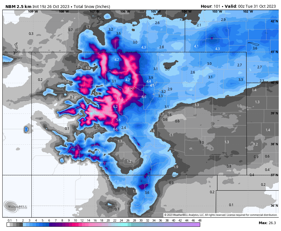
A major surge of moisture will impact Colorado Friday evening, bringing significant snowfall to the central and northern mountains of Colorado. We’re looking at widespread totals exceeding a foot, with local maxima exceeding 2 feet. This will help nudge resorts closer to opening, with fresh snow and cold temperatures likely meaning the first lifts will begin spinning sometime next week or weekend.
Announcement: Get your snow tires on now and support our gold sponsor Tire Rack in an overnight delivery with several promotions currently. Tire Rack Link They can deliver overnight to a Discount Tire store or at your home (Discount Tire and Tire Rack are 1 company now) with a warehouse In Denver.
A small primary wave moved through the western and northern slope of the mountains last night, dropping just a dusting to a few inches in the mountains. The larger push works its way into Colorado from the west and southwest starting late on Friday night in the western mountains and pushing further east overnight. By sunrise on Saturday, snow should be falling in mountainous regions above 8,000-9,000 feet essentially across the state. On Friday night and Saturday morning, the heaviest precipitation will be falling in the central and northern mountains, north of Aspen and the Elk Mountains. However, this storm does have a strong southwesterly wind component at the start, so look for resorts a little further like Crested Butte, Telluride, and Wolf Creek to out-perform the forecast early on. Notice the strong southwesterly winds projected for Saturday morning:

Winds on the backend of the storm will shift to a northwesterly and northerly origin on Saturday evening and night, which will favor the Steamboat and Aspen regions, so look for these areas to potentially exceed the forecast on the tail end with the extra orographic boost that the models are not high enough resolution to pick up on. Check out the north/northwesterly flow on Saturday night below. The northwesterly and southwesterly winds converge over the central mountains around Aspen and Vail, which will cause strong vertical motion and could spawn some very intense snow bands that may help drive their totals beyond the forecast. This central convergence is part of the reason I feel so confident about the highest totals being in the central mountains.

The snowfall will shift to the central and southern mountains on Saturday night, with the precipitation continuing to move south and wane during the day on Sunday. Now, let’s talk about storm totals.
There will be widespread 1+ foot totals in the central and northern mountains above 10,000 feet. As of right now, the bullseye looks to be around the Aspen area, especially the Western Elks and Snowmass due to its position a little further west than the other resorts. I see Snowmass approaching 16-22” range when it’s all said and done on Monday.
The precipitation moves south on Saturday too early for Steamboat to pick up as impressive totals, but I still see them ending up in the 6-10” range. Remember, that northwest flow on the tail end of the storm on Sunday could help them push past the one foot threshold, but it’s better to be pleasantly surprised than bitterly disappointed, so keep expectations for an 6-10” storm total.
By Monday, Vail and Beaver Creek are looking at 10-18”. Summit County resorts will benefit from high elevation, meaning low temperatures and light, fluffy snow, which will help totals. Summit County resorts have the biggest upside in this storm; those low temperatures could cause deep snow to pile up extremely quickly if nice precipitation bands set up overhead. Right now, it’s looking like 12-18”, but there is a very good chance they end up on the higher end of that range or even exceeding it.
Check out the European and American models' projected snowfall by Monday. Keep in mind that these are using 10:1 snowfall ratios, but in reality, colder temperatures will mean this snow is much fluffier, so these forecasts are likely significantly underestimating what will soon end up being reality. Also, remember that these global models are low-resolution and cannot properly resolve complex terrain influences that locally boost precipitation amounts:

This storm will also bring much below-normal temperatures afterwards, meaning it will bring ideal around-the-clock snowmaking conditions for all of next week. Between ideal snowmaking conditions and significant snowfall this weekend, I’d say resort openings sometime next week or weekend are looking increasingly likely. Fingers crossed!
Please join our custom forecasting program on the "powder concierge" that allows us to steer you to the deepest storms all season. You can also support us with a donation here, or purchase some swag on our website.


