
The Epic Watch issued a few days ago has been upgraded to a warning for multiple days of snowfall overspreading the west. Peak snowfall for the incoming atmospheric river will hit from Friday (PNW) through the Rockies through the weekend.
Additional snowfall will continue, especially in the PNW and Sierra, into much of next week. Temps are warm initially in the Cascades and crash to nearly 1,000 feet or less by Saturday. Temps in the Rockies are respectable in the northern regions with a cold front roughly bordering far Utah north, but more likely in Wyoming and many areas of Idaho. The positioning of this cold front will be key to snow quality.
In the short term, as of Thursday morning, a wave of snowfall brought up to 10 inches to the San Juan Range in Colorado. Here are a few snow totals as of Thursday morning. This was much-needed snow for regions without a double-digit storm in at least a month.
Purgatory: 10 inches
Taos: 11 inches
Wolf Creek: 7 inches (Estimated).
Projected snow totals through Sunday morning for the upcoming storm in the west. These totals do not include next week.
Crystal: 9-15 inches
Stevens: 14-24 inches
Alpental: 14-24 inches
Baker: 10-20 inches
Bachelor: 12-18 inches
Whistler: 7-14 inches
Revelstoke: 7-14 inches
North Sierra above 8500: 10-14 inches
South Sierra above 8500 6-11 inches
Selkirk Powder: 12-14 inches
Schweitzer: 12-14 inches
Whitefish: 5-9 inches
Brundage: 9-15 inches
Sun Valley: 7-10 inches
Targhee: 7-14 inches
Jackson Hole: 10-16 inches
Beaver: 7-12 inches
Alta: 7-15 inches
Park City: 5-10 inches (Mid and upper elevations)
Powder: 6-14 inches (Mid and upper elevations)
Below is the total snowfall from Friday morning through Sunday morning per the European model. These totals will be higher in the PNW, with the coldest temperatures increasing ratios. Utah's path of this storm is still in question, with the latest models pushing a bit further south than precious runs (Cottonwoods are back in the game on today's models where previously the heaviest totals were north of I-80.

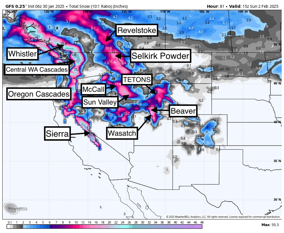
Below: The American GFS is even more bullish for totals in the west through Sunday. Snow will edge south into the northern and central Sierra ranges. However, temperatures will initially bring rain to the bases in northern CA this weekend before colder air next week.

Chase Issues: Chasing the coldest temperatures is the biggest key to this storm, which appears to land north of Utah. The Sierra is warm, with snow levels in the 8500 to 9,000 range this weekend. Utah is on the cusp of the colder air near Beaver Mountain in the far north (Wildcard on temps). Areas of Wyoming, Idaho, and Montana are colder.
Below: 10K foot temps per the GFS model shows a distinct line of cold air favoring the northern Rockies this weekend. While areas south will still see respectable totals, the density will be high. In the PNW, snow levels start at 3500-4,000 on Friday but crash to 1,000 on Saturday. Convergence zones with westerly winds and these colder temps will bring significant snowfall to the I-90 corridor and areas near Stevens Pass.

Extended Powder:
Colder temps push snow levels to nearly 6,000 feet in the Sierra early next week (Better quality). This colder air sneaks slightly south into Utah. Moisture is plentiful in many areas of the west, including the PNW, Sierra, and most of the Rockies. We are not going to get into specifics just yet. Some areas of the west might top out on 7-day totals in the 20-50 inch range!
Below: 5-days total snowfall next week from Monday to Friday. Decent totals next week for many areas from the PNW, Sierra, and the north-central Rockies (Favors the Tetons, Idaho, and Utah). Chases might land in the highlighted zones below. The temperatures will warm again late next week so that we might deal with very dense snow after midweek.

If you want to chase powder, join our concierge program below.
NOTE: Please support Powderchasers with a donation, Merchandise purchase such as a hat or stickers, or sign up for our custom Concierge Powder Forecast Package, where we provide 1:1 phone and email support to get you to the deepest locations possible.
Forecaster: Powderchaser Steve @powderchasersteve (Instagram).


