
Summary:
Hold on tight! Waves of moisture continue in the west, with up to 14 inches thus far in northern Washington and areas near Bachelor. Several feet expected for the Sierra, Tetons, and the north Wasatch Range. Pacific Northwest grabs 1,000-foot snow levels. The central or southern Rockies skyrocket to 8-9,000 feet (Rain at lower elevations). Colder air is noted north (Wyoming, Idaho, Montana). The Sierra grabs 50 up top. Cold air is noted both mid next week (Briefly), with a better deeper and low density storm possible late next week/weekend. Temps initially next week will formulate tricky chases.
Sponsor Alert: (New Ski Tracking)
This post is sponsored by Tracked Out, the ultimate ski tracker for iPhone. Looking for more than just basic stats? Tracked Out delivers detailed metrics and real time feedback from Ski Sensei, a personalized coach, to help you make the most of every run.
Forecast:
Complex chases by region.
Below: Powderchaser Steve at Mt Baker on Friday morning (15 inches by noon).

PNW
Bottom Line: Chase into the PNW will be good Friday night as the snow level crashes from 3500 feet to 1,000 feet by 10 PM. SW flow initially favors Baker (My chase on Friday), where up to 14 inches of dense snow fell today. Areas south in Washington picked up lower totals (3-7 at Stevens), with Oregon resorts in the moderate range. When looking at chasing, wind direction and cold air are key components to enhanced totals. Westerly flow Friday night might set up a Puget Sound Convergence Zone, bringing possible I-90 (Alp) and areas near Stevens Pass 5-10 additional inches. Winds, however, are also favored in the W SW direction, so Baker would be another solid contender.
Below: The cold front is over the Cascades (WA, OR) by 11 PM Friday (Low-density fluff).

Below: Additional snowfall Friday night in the Cascades seems to favor northern Washington and Oregon through Saturday morning.
My expected snow totals for Friday night are below.
Baker: 9-15
Stevens Pass: 5-11
Alpental: 4-8
Crystal: 4-8
Timberline: 7-14
Selkirk Powder: 4-9
Schweitzer: 4-9
Bachelor: 6-12

Due to the cold temps, snow ratios will be near 15 or 18:1 after midnight, so with this map showing at 10:1, the cold air late Friday will increase the displayed totals.
Rockies or Sierra Chases:
Bottom Line: Moisture is plentiful in the northern Sierra Ranges, Idaho, Wyoming, and N Montana. Warm air is draped over California (no-go) and extending into Utah (7,000-foot snow levels), bringing medium to medium-density snow to the Wasatch (northern areas above I-80 are likely to see the highest totals Friday night and Saturday).
Colder air is noted in central to north Wyoming (5,500 snow levels) with better quality, including the Panhandle and western Idaho (McCall area). For those Cottonwood Canyon hoards, Friday night may be moderate (4-7), with higher totals towards the summits of Powder, Snowbasin, or Beaver near Logan.
The Tetons might have double digits by Saturday midday (5500-foot snow totals) with snow and wind continuing before a short break Saturday evening.
Expected snow totals through Sunday night.
Brundage: 7-14 inches
Whitefish: 5-11 inches
Sun Valley: 4-8
Targhee: 12-15
JHMR: 14-20 (Mid to upper)
Alta: 7-15
Beaver: 9-16
Park City: 5-11 (Mid to upper elevations)
Powder: 9-17 (Mid to upper elevations)
Snowbasin: 9-17 (Mid to upper elevations)
Solitude: 9-16
Steamboat: 4-9 inches
Below: Colder air is noted at 10K (map) over Wyoming and Montana Friday night/Early Saturday.

Below: Alta on the GFS is a bit pessimistic, with 7 inches by 7 AM Saturday and 10 inches by 5 PM. I think that is reasonable. Higher totals are likely further north. BCC might do a bit better with SW flow or DV and PCMR (upper elevations only).

Below: Snow-to-liquid ratios start at 10:1 Saturday (February 1 on this graph) for Alta but migrate to as low as 5:1 by February 3-4 next week (Monday/Tuesday). This storm is a bust quality-wise, aside from perhaps early Saturday when it is cooler. Avalanche conditions will spike as this storm cycle continues (Stay out of the Backcountry as these temps rise). Density improves mid to late next week, per this graph.

Below: JHMR totals range from 20 to 40 inches in the next 5 days. Targhee will see similar totals (Slightly lower due to W, SW winds versus NW).

Below: Snow-to-liquid ratios are higher in the Tetons with cooler temperatures. They are 10:1 or 12:1 initially (Good medium-density snow) but migrate to 8:1 by Monday next week (possibly rain mix below 6700).

Below: Warm air hits Wyoming Monday and Tuesday, with temperatures at 10 K feet reaching 28F (Ouch). In Utah, temperatures are above freezing early next week. All ski areas will have significant avalanche mitigation with this storm, perhaps as early as Saturday or Sunday, with the warmest air arriving Monday/Tuesday.

Below is the total snowfall through Saturday night in the Rockies and Sierra. This model favors the northern areas of Utah, as well as many spots in Idaho, northern Montana, and the Tetons. The southern Wasatch is a wildcard, with some models showing deeper pockets south of I-80. PCMR might see some mixed precipitation at the bases. Map (NAM-12 short-term model).

Below: Total snowfall through this Sunday afternoon (Waves continue). You can see some snow by Sunday in northern areas of Colorado.

Extended POW
Below: The general trend is for storms to favor southern Oregon and the Sierra Ranges (North and south). This map shows 24-hour snow totals from late Monday, February 3, through Thursday, February 6th. Several periods of double digits are possible. Snow tracks east over Idaho (Sun Valley can do well in this pattern) and the Tetons. Temps will initially be an issue next week! More snow hits the west late next week and weekend with colder air.

Below: Temps are critical to any chases. This map is from Monday morning, February 3, to Saturday, February 8 (Date and day are in the upper right). The Sierra stays warm until Midweek (The cold front brushes the northern Sierra). The PNW and far northern Rockies (Montana) regions remain cold. You can see warm air over Utah, Wyoming, Idaho and Colorado. Colder air midweek favors the north Rockies and Idaho midweek (Above Utah). Frigid air will move into all areas including Cali by late next week (More snow and better quality will be possible). There are good odds of a high-quality storm in many areas late next week with the colder air.

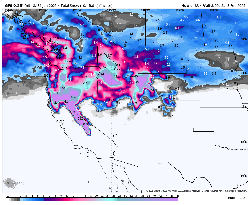
Below: Total 7 day snowfall for the west ending through February 8th. While this is a bit of a fantasy map, I do think it is reasonable, however the higher totals will only exist at upper elevaitons, especially in the Sierra, and perhaps Utah where temps are warmer. Base areas in many locations will see much lower totals.

Please support Powderchasers with a donation, Merchandise purchase such as a hat or stickers, or sign up for our custom Concierge Powder Forecast Package, where we provide 1:1 phone and email support to get you to the deepest locations possible. When chasing snow, the Concierge gets you the best intel. Make sure to sign up for our free email list so you never miss a powder day. We are looking for new sponsors as well as ambassadors who want to submit photos and videos.
Powderchaser Steve or @powderchasersteve on Instagram


