
POW Summary: We have issued an Epic Watch for the ridge to break down later this week and slam the PNW and the core of the northern Rockies. How far south this storm digs is still unclear, making some big wildcards for Utah and California. Colorado might also land too far south, but let's hope this changes. In the short term, we have some snow in the forecast for the Four Corners.
This post is sponsored by Selkirk Powder, which offers Cat Skiing in a vast area of northern Idaho. This region of Idaho will receive decent snow totals from Friday to Saturday this week. Please check out Selkirk Powder if you want to ride crowd-less powder in the pristine wilderness north of Sandpoint, Idaho. They still have open slots.
Forecast
Finally, some decent moisture hit the southern California Coast, with up to 1 inch of moisture in the Los Angeles area and 10 inches reported at Mt Baldy (In my range of the forecast). Baldy was closed on Monday and opens today (Tuesday). Minimal terrain is open, but it will be the first chance to score a face shot in California all season.
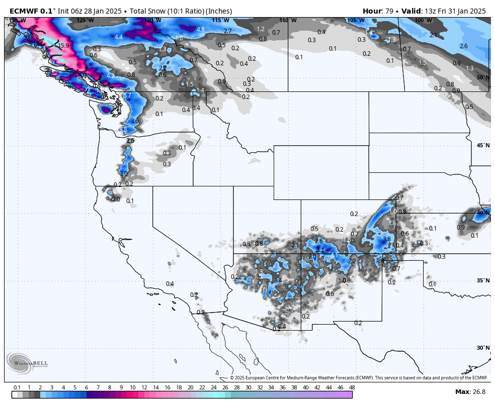
The models bring light to moderate snow to Arizona, Colorado, and northern New Mexico on Wednesday/Thursday. There are distinct differences in solutions, with most models keeping 3-7 inches in most areas of Arizona, Northern New Mexico (Taos), and the San Juan Range of Colorado (Purg, Wolf). However, 1 model points to a more profound solution over southern Colorado (Short Term Nam), aiming to storm ski Wednesday (The last chair could be decent) and some new tracks for Thursday. It's likely not a deep system, with our low-end forecast in the 3-6-inch range. The upside is some isolated bands, likely in the southern Colorado mountains of 5-11 inches.
Below: American GFS is showing 3-6 inches for the San Juan Range of Colorado by early Thursday, with higher totals over Taos (Pink area). Timing: Wednesday morning to Thursday morning.

Below: The short-term NAM is bullish for Colorado and much less for New Mexico (5-12 inches for the San Juan Range, including Telluride, Purgatory, and Wolf Creek.

Bottom Line: High odds of 3-6 inches from Flagstaff, Arizona, into southern Colorado and northern New Mexico. Outside upside for north New Mexico and southern Colorado for 5-11 inches. Ride late Wednesday to early Thursday.
Extended Forecast Looks Deep, so don't stop reading.
The ridge breaks down over the west by Thursday as storms can re-enter the Pacific Northwest and BC by Friday morning. This low brings ample moisture into this area from Friday to Sunday. Warm air initially on Friday could make the snow slightly upside down with moderate to strong SW winds.
Colder air arrives in the PNW late Friday to Saturday, with lighter-density powder and even some snow, possibly in the higher elevations of metro areas. The timing for riding powder will be Friday (Storm Ski) for Whistler and the Cascades of Washington and Oregon (It starts a bit early the further north you travel). Some overnight pow will be found for Saturday morning with much colder temps and winds from the W and NW.
Below: Friday morning, Washington and Oregon show a warm front ) pushing into the Cascades, pushing snow levels into the 3500 to 4,000-foot range (near most bases). This is followed by colder temperatures from Friday night to Saturday (-9C). This could bring snow showers to the lower elevations outside metro areas of Seattle. There will be a significant temperature drop from Friday to Saturday.

Below: Total snowfall in the PNW will be plentiful, peaking Friday to Saturday. This will also bring moderate totals to the interior of BC (5-10) and areas near Schweitzer and Selkirk Powder in northern Idaho. Areas on the western Cascades (Washington and Oregon) could nab 12-20 inches by midday Saturday. Western BC resorts will see similar totals while temps in Canada remain a tad cooler for the storm skiing on Friday. Finally, a storm to talk about! The Good: Significant snow. Cold temps and good quality by Friday night. The Bad: Breezy winds Friday and a slightly warming trend could impact some upper lifts in the Cascades (50% chance), and snow quality might start upside down (We need that right now). Bottom Line: Good storm for much-needed powder. There's not much downside.

Below: Snow pushes east over the Rockies, favoring northern Idaho, northern Montana (Whitefish), central Idaho (Brundage, Tam), Tetons, and the Wasatch Range. Per the GFS, widespread 12-18 inches are likely in many of these areas. Timing: The Rockies see impacts on Saturday/Sunday. The Sierra is on the northern edge of this storm but will likely see some powder by Saturday morning (5-9). By Sunday, we could exceed 20 inches in a few areas of the northern Rockies and western Idaho.

Below: The European, as opposed to the GFS, favor areas just north of the Wasatch, with higher snow totals noted for the northern Rockies versus central regions of the Salt Lake area mountain ranges.

Below: Ensembles are generally in the 20-30 inch range for Crystal Mountain from Friday to Sunday. My take is a mean of 20 inches only since SW winds initially for this storm are a bit better for the north Cascades on Friday, with W, NW winds a wildcard for the Central or southern Cascades. Most of the Cascade Range will do well with this storm, especially the western crest.

Below: Significant differences between the European (Pink) for Jackson Hole and the GFS (Blue) for between 18 and 35 inches. These ensembles are often overdone, with my mean forecast from Saturday to Sunday in the 20-inch range. JHMR could do well initially with SW flow, and Targhee could do better later in the storm cycle with NW winds.

Below: Lookout Pass Idaho should land in the 15-20 inch range from Friday to Sunday.

Bottom Line Chase: It's tough to nail the winners due to a lack of natural snow in the past few weeks. The PNW would be a solid bet for Friday-Sunday, including Whistler and most of the W Cascade Ranges for deep snow. Interior BC could grab a foot with northern Idaho, which is also a good bet. Move east for Saturday and Sunday, or stay in the PNW for continued snow showers.
Western Idaho and the panhandle of Idaho will also be deep, and northern Montana will be deeper than southern regions. The Tetons have high odds of double-digits on Saturday/Sunday. The Wasatch is a wildcard, with a few models keeping moisture north, which could result in 4-8 inches versus 10-18. It is simply too early to narrow in Utah.
Colorado looks to stay on the southern side of the bulk of the action.
Due to the odds of deep snow, this might be a good time to join our Concierge program below.
NOTE: Please support Powderchasers with a donation, merchandise purchase(such as a hat or stickers), or sign up for our custom Concierge Powder Forecast Package, where we provide 1:1 phone & email support to get you to the deepest locations possible. When chasing snow, the Concierge gets you the very best intel. Sign up for our free email list so you never miss a powder day. We also seek new sponsors and ambassadors who want to submit photos and videos. Follow us on FB and Instagram @powderchasers
Forecaster: Powderchaser Steve @powderchasersteve (insta).


