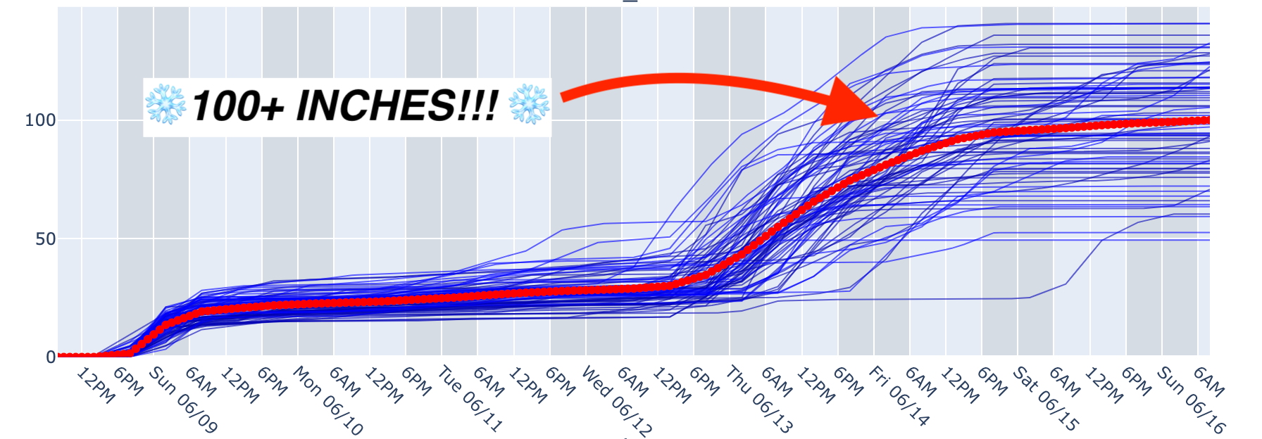
Another massive storm cycle will slam the Andes this week, building on what has already been an extremely impressive start to the season so far. This storm cycle will be comprised of two main waves, one from Saturday morning until Monday morning and one from Monday morning through the entire week and into next weekend.
Storm #1 from Saturday AM - Monday AM will be dominated by warm temperatures, especially on the front-end of the storm. Take a look at the massive blob of warm air sitting over the region on Saturday:

Temperatures at many mid-mountains will be in the mid-40s to start this storm. However, a cold front will sweep through on Saturday afternoon, bringing much-needed cold temperatures especially in the northern region, including resorts like Portillo & Valle Nevado. Precipitation will accompany the cold front, sweeping from the south to the north between Saturday morning and Monday morning. Resorts in the south will see mostly rain transitioning to snow, while central and northern resorts will fare better with more snow considering the more potent arrival of the cold temperatures. Check out that cold air come rushing in during the day on Saturday (especially in the north):

By the time precipitation has mostly died down from the first wave on Monday morning, resorts in the south (Cerro Catedral, Cerro Bayo, Chapelco, etc) will have only seen 3-6" of wet snow on the tail-end. Further north, Pucon and Corralco should pick up 10-20". In the northern region at resorts like Las Leñas, Portillo, and Valle Nevado should be looking at 12-24" of snow.
The second storm is a tricky one, and the exact timing of these waves remains vague. A series of small storms embedded within this main system will sweep plumes of moisture into the mountains, mostly relegated to the south until things really get cranking in the north on Wednesday afternoon. Totals will stack up FAST at Portillo, Valle Nevado, and Las Leñas, and with Portillo and Valle Nevado spinning their chairs already, it should make for great chasing conditions. Snow quality will improve throughout the storm as temperatures continue to drop, so chasing conditions will be best later in the week; peak snowfall quality will be around Friday morning with ratios between 14 and 17:1. Snowfall should die down on Saturday but could continue through the weekend at some resorts.
Here are projected snowfall totals from around the region from both storms combined by next Sunday morning. Remember that there is a ton of time for this storm to evolve over the coming days; these are our best guesses at the moment factoring in all the uncertainties, but are likely subject to change.
- Las Leñas: 75-125" (190-320cm)
- Valle Nevado: 80-120" (200-300cm)
- Portillo: 60-100" (150-250cm)
- Nevados de Chillan: 65-100" (165-250cm)
- Corralco: 65-90" (165-230cm)
- Pucon: 40-65" (100-165cm)
- Caviahue: 25-50" (65-125cm)
- Chapelco: 15-30" (40-75)
- Cerro Catedral: 12-25" (30-65cm)
The Powderchasers ensemble model is indicating a 96.25% chance of Valle Nevado exceeding 5 feet (150cm) and a 51.25% chance of exceeding 100" (250cm) by next weekend! That's DEEP!
Below is the GFS (left) and ECMWF (right) forecasts for total precipitation by next weekend. You can see the GFS is very aggressive with precip and concentrates the heaviest more in the north by Valle Nevado and Portillo, while the ECMWF is depicting less and more evenly distributed precip:

Regardless of which precip solution ends up being correct, it's safe to say that both models are aggressive with snow from this storm system:

Looking ahead, the following week is a tossup, with some models indicating continued stormy conditions and some models indicating high and dry weather. Much of this uncertainty will be ironed out with the passing of each storm this week, as more and more conditional dependencies will be eliminated as we move those storms from forecast to observed. Below shows the ECMWF ensemble depicting neutral precipitation conditions two weeks from now:


