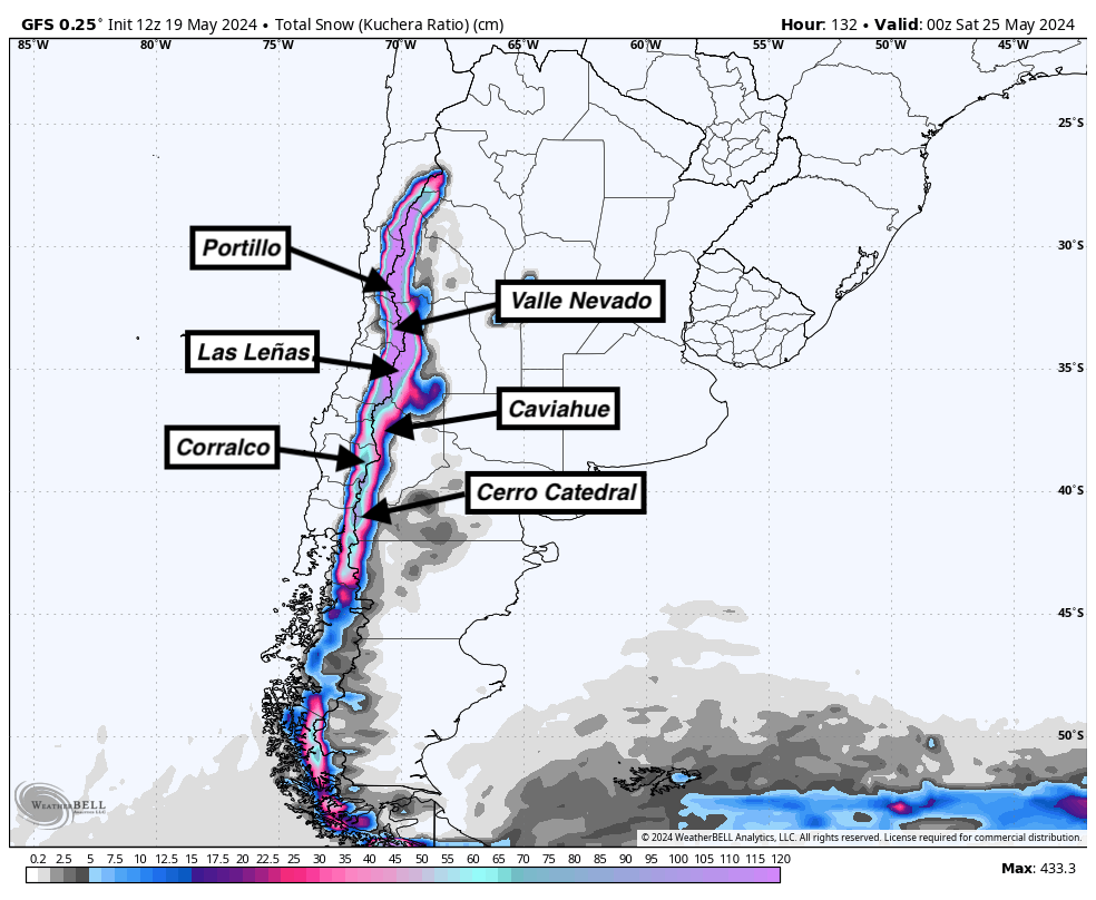
The first major storm of the season will hammer the Andes this week, dropping over 5 feet of snow at resorts around the region. The most favorable region for snowfall will be in the north, especially around Portillo and Valle Nevado.
Nevados de Chillan is doing a short celebratory opening through May 21 but some resorts may move up their opening day following the storm later this week so skiers and riders can get out and enjoy the new snow. Right now Corralco in Chile is open daily as well as Antuco in Chile.
Precipitation starts on Sunday afternoon in the south around Bariloche. Strong precipitation will continue on Sunday night and Monday morning before decreasing significantly by Monday afternoon. Winds will peak on Monday, bringing 50+ mph winds to upper-elevations:

A small secondary wave will roll through between Monday evening and Tuesday evening. Models are indicating 10-14" at Cerro Catedral and 15-20" at Cerro Bayo by Tuesday night. Ensembles are indicating a 50% chance of more than 18" at Cerro Bayo, so keep an eye out for the deepest totals in the southern region at Cerro Bayo.
In the north, Las Leñas, Portillo, and Valle Nevado will be big winners. Nearly continuous heavy snowfall will persist from Monday morning through Thursday evening. When it's all said and done, we'll be looking at some very impressive totals in this northern region:
- Valle Nevado: 50-75" (125-190cm)
- Portillo: 36-50" (90-125cm)
- Las Leñas: 30-50" (75-125cm)
Valle Nevado will almost certainly be the winner of any South American resort; the Powderchasers super-ensemble is indicating a 100% chance of over 24 inches, a 95% chance of over 36 inches, an 84% chance of over 48 inches, and a 54% chance of over 60 inches. Not bad at all for a mid-May storm...
Just take a look at the Powderchasers super-ensemble forecast at Valle Nevado. A few members are even exceeding 100 inches!

Take a look at totals from the ECMWF (left) and GFS (right) models below. In reality, these forecasts are both likely too low; they assume a 10:1 snow-to-liquid ratio while in reality, snow ratios will be between 10 and 15:1 for the duration of the storm for most higher-elevation resorts. Notice the bullseye in the north around Portillo & Valle Nevado:

A very weak system is possible in the region next weekend (a couple of inches possible) before it looks like some strong blocking will take over and prevent much moisture from making it in for at least about a week:

This is a bonus post for 23/24 and encourage all of you to please donate on our website or purchase the swag. The donations help us more so if you have taken advantage of chasing powder, or living vicariously through Powderchasers please contribute here. We survive on your help from the powder community. Donate: https://powderchasers.com/pages/donate-to-powderchasers
Swag is available here with a special sale on all the new tee shirts. https://powderchasers.com/collections/frontpage


