A sequence of storm systems is set to bring substantial snowfall across the Western United States this week, impacting regions from the Pacific Northwest to Colorado. While current models show some discrepancies—particularly concerning the extended forecast—significant accumulations are anticipated in several mountainous areas.
Current Conditions- Snorkel Alert!
Snow is currently underway across Colorado as the first storm system wraps up its passage through the region. The headlines are significant snow fell overnight in Colorado, Sunday into Monday morning (November 4) that brought up to 20 inches to a few resorts in Summit County
Below: Overnight pow at Breckenridge Monday morning November 4th.

Below: Buried snow cam at Copper (Likely 20 inches).

Upcoming Storm System
A second storm is moving into the Pacific Northwest this morning and is poised to impact several regions over the next few days.
Pacific Northwest (Monday AM through Tuesday Early Afternoon)
The storm will affect the Pacific Northwest from this morning through early Tuesday afternoon. Moderate snowfall is anticipated during this period.
Northern Rockies (Monday Afternoon through Early Wednesday Morning)
The system is expected to swing north into Idaho, Montana, and Wyoming from Monday afternoon through early Wednesday morning. Snowfall accumulations are projected to be 3–6 inches for most areas, with up to 10 inches in the highest peaks of the backcountry.
Utah (Tuesday Morning Onward)
The storm will tease Utah on Tuesday morning (Southern Fringe) Resorts can expect light snowfall, with accumulations ranging from 2–4 inches Below is the short term NAM 12 for Utah through Tuesday morning. Amounts might sneak up slightly in the Cottonwoods but our confidence on a deeper storm are low.

Colorado Cutoff Low (Late Tuesday Morning through Saturday Afternoon)
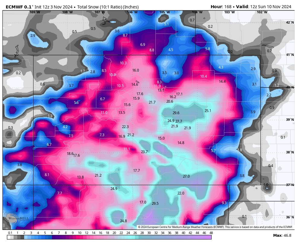
In Colorado, the storm will evolve into a cutoff low that will linger over the region, producing snowfall from late Tuesday morning through Saturday afternoon. The cutoff low positioning to the south of Colorado will result in winds coming from the southeast, NE and North. This puts a bit more uncertainty on who scores the highest totals.

Snowfall Accumulations
-
Models and Uncertainty
- The ECMWF is suggesting widespread snowfall totals of 10–25 inches across the Colorado mountains.
- The GFS remains more conservative, indicating totals of 6–15 inches.
- Models have not yet reached a consensus and are displaying significant variability. Further updates will be provided on Tuesday or Wednesday morning as new data becomes available.
- Below is the comparison between the ECMWF and GFS forecasts. The GFS is less optimistic for midweek and further east.

-
Impact on Denver and Eastern Plains
- The east-southeasterly winds could bring substantial snowfall to Denver and the eastern plains (Southern areas favored).
- Major accumulations are possible, particularly in the southeastern mountains, but significant snowfall is anticipated across the eastern side of the mountains. Model uncertainty exists.
Projected Snowfall Totals
Please note that these figures are subject to change as forecast models are updated.
Intermountain West (By Tuesday November 5)
- Schweitzer: 5–10 inches
- Big Sky: 8–14 inches
- Jackson Hole: 6–10 inches
- Grand Targhee: 10–15 inches
Utah
- Cottonwood Canyon Resorts: 2-4 inches
- Park City/Deer Valley: 1-3 inches
- Powder Mountain: 2–4inches
Colorado and NM (by Sunday November 10)- Midweek storm
- Steamboat: 7–14 inches
- Winter Park: 9–15 inches
- Arapahoe Basin/Loveland: 9–15 inches
- Breckenridge/Copper: 8–15 inches
- Vail/Beaver Creek: 5–10 inches
- Aspen/Snowmass: 8–16 inches
- Crested Butte: 6–12 inches
- Monarch: 14–22 inches
- Telluride/Silverton: 12–20 inches
- Wolf Creek: 20–30 inches
- Taos: 15-20 inches
- Ski Santa Fe: 20-24 inches
Please support Powderchasers with a donation, Merch purchase, or sign up for our custom Concierge Powder Forecast Package where we provide 1:1 phone and email support to keep you in the deepest locations possible. Outside Magazine listed Powderchasers as in the top 3 sites with the custom concierge program. This supports us and keeps you chasing the deepest snow all winter.
Extended Outlook
Pacific Northwest Storm (Friday Evening through Sunday Morning)
Another storm system is expected to arrive in the Pacific Northwest on Friday evening. Forecast models diverge on its impact:
- GFS: Predicts the storm will dissipate quickly, resulting in minimal effects.
- ECMWF: Indicates a more significant system lasting through Sunday morning, coming in with warmer temperatures. Snow levels are projected between 5,000 and 7,000 feet, which could lead to rain at resort elevations if the storm materializes. Check out the warm and wet ECMWF forecast for Sunday below. That's a lot of rain...

Late Weekend Storm (Sunday Evening/Night)
Models show agreement on a subsequent storm arriving Sunday evening:
- ECMWF: Portrays this as a typical La Niña system that will impact the Pacific Northwest before moving into Idaho, Montana, Wyoming, and Colorado, with a brief impact on northern Utah.
- GFS: Suggests the storm will deepen and shift south into California, potentially bringing significant snowfall to California, Utah, and Colorado if this scenario unfolds. Check out the GFS lighting up California early next week:


