
A train of storm systems will hammer the West with multiple rounds of significant mountain snowfall, keeping powderhounds on high alert through the weekend. The heaviest snow is likely across California’s Sierra and the Wasatch in Utah, where multi-foot totals are expected through Saturday. Elsewhere, Colorado’s high country, the Pacific Northwest volcanoes, and the Northern Rockies will see solid refreshes as well. Timing is everything: Thursday into Friday looks prime for many areas, especially in the Sierra and Wasatch, with Colorado and the Pacific Northwest seeing their biggest hits Thursday night and Friday. More unsettled weather may return by early next week, so keep your skis waxed and be ready to chase frequent refills.
This post is sponsored by Beaver Mountain. They have been family owned and operated for 81 years. Located in northern Utah, they receive that great Utah powder (including over a foot likely this week). A great ski and snowboard experience without the prices or crowds of the big resorts.
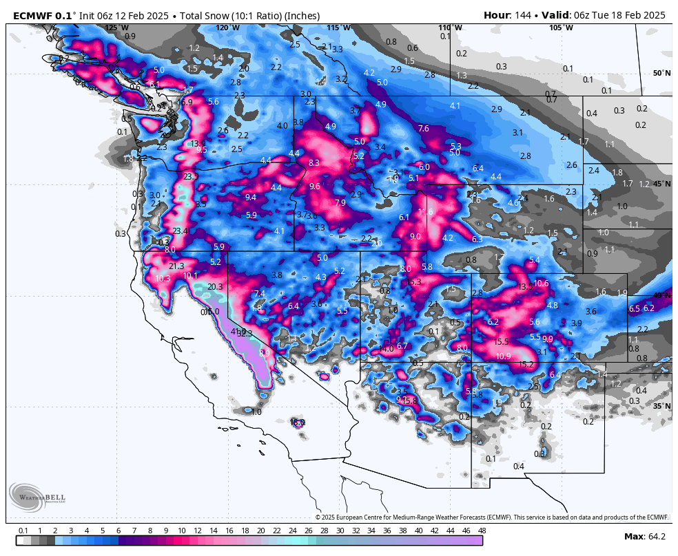
California

Chase advice: Thursday and Friday will be the highlight, with deep, high-quality snow likely at Tahoe-area resorts and especially Mammoth. If you can stay through Saturday, you’ll score excellent post-storm conditions as skies clear and fresh snow piles up. Expect big powder days at Kirkwood, Palisades Tahoe, Mammoth, and Sugar Bowl.
A strong winter storm will slam the Sierra Wednesday night into Friday, bringing heavy snow to all elevations above roughly 5,000–6,000 feet. This system ushers in abundant Pacific moisture, leading to snowfall rates that could exceed an inch per hour in favored spots. Colder air moves in by Thursday, ensuring snow levels remain relatively low, although mild intrusions at times may bring mixed precipitation below 5,000 feet. Winds will be brisk from the southwest, especially early Thursday into Friday, with gusts over 50+ mph in exposed terrain. Check out the ECMWF wind forecast at 10,000 feet on Thursday, featuring strong winds out of the southwest that may affect upper-mountain lift operations:

Snowfall will persist in the higher elevations through Friday as the system’s main energy moves inland. Expect multiple feet of accumulation along the Sierra crest, with slightly lower amounts at resorts tucked to the east. By Friday night, the storm gradually tapers off, leaving behind substantial snow depths ideal for powder turns. Valleys may see rain or a brief mix, but precipitation in the mountains remains all snow through the event.
Another minor disturbance may clip northern portions of the state late Saturday into Sunday, though impacts look smaller. The Sierra could pick up additional light accumulations, but coverage will be more scattered. Meanwhile, a short break in storms Saturday afternoon should allow for clearer conditions and a short breather before the next wave arrives.
Medium-range outlooks (early next week) suggest a continued wet pattern, though the heaviest moisture may shift north. That said, conditions in the Sierra could remain generally active, so watch for further opportunities mid- to late next week. Temperatures should stay near or slightly below normal, so additional snowfall is definitely on the table.
Resort Forecast Totals
- Mammoth – 31–45” Wed night (02/12)–Fri night (02/14)
- Kirkwood – 29–42” Wed night (02/12)–Sat (02/15)
- Palisades Tahoe – 26–38” Wed night (02/12)–Sat (02/15)
- Sugar Bowl – 26–38” Wed night (02/12)–Sat (02/15)
- Northstar – 19–28” Wed night (02/12)–Fri night (02/14)
- Heavenly – 14–21” Wed night (02/12)–Fri night (02/14)
- Mt Rose – 14–21” Wed night (02/12)–Fri night (02/14)
Utah
Chase advice: The heart of the storm is Thursday into Friday for nearly all Utah resorts, with storm totals pushing two to three feet in the Cottonwoods. Park City/Deer Valley should see an excellent refresh, while southern Utah’s Eagle Point also scores moderate accumulations. Plan to ski Friday and possibly Saturday morning for the best new-snow conditions.
A potent storm system takes aim at Utah starting Thursday morning, bringing heavy snowfall to the Wasatch Range and southern mountains. Snow levels will initially be low enough for nearly all resorts to start with snow, although valleys may see some rain at times by Friday afternoon below about 5,000 feet. Southwest winds crank up as moisture streams in, especially Thursday, but the real story is multi-foot snow totals in favored terrain.
Heaviest snowfall will occur Thursday afternoon through Friday, accompanied by periods of high-intensity bursts. Conditions will remain stormy for higher elevations as temperatures hover below freezing. By Friday night into Saturday, the storm’s center shifts east, but lingering wrap-around moisture could sustain lighter snow in the mountains. Winds gradually veer northwest, enhancing a few final pockets of accumulation in the Cottonwoods. Check out the official NWS forecast showing 35" at Alta... this feels a bit high, but gives you an idea for how potent this storm could end up for the Wasatch:

The weekend brings a slight break, although scattered snow showers may flare up Saturday, mainly in northern Utah. Temperatures begin to moderate, but any sunshine will be brief before the next wave of energy potentially arrives early next week. Exact timing of that wave remains uncertain, but another shot of snow cannot be ruled out heading into Monday or Tuesday.
Medium-range outlooks keep Utah in an active storm track, albeit less extreme than the immediate short-term event. Odds favor near to slightly below normal temperatures, so additional snow is possible, especially across the Wasatch. It’s shaping up to be a productive pattern for mid-February.
Resort Forecast Totals
- Alta/Snowbird – 23–35” Thu (02/13)–Sat night (02/15)
- Solitude/Brighton – 21–33” Thu (02/13)–Sat night (02/15)
- Powder Mountain – 18–29” Thu (02/13)–Sat night (02/15)
- Park City/Deer Valley – 17–27” Thu (02/13)–Sat night (02/15)
- Beaver Mountain – 11–18” Thu (02/13)–Sun (02/16)
- Eagle Point – 11–18” Thu (02/13)–Sat night (02/15)
Colorado
Chase advice: Focus on the Crested Butte and San Juan areas Friday into Saturday, with a potential for double-digit totals by Saturday morning. Resorts around Aspen/Snowmass and Wolf Creek should also see plenty of powder. Friday looks like the sweet spot for fresh turns, but Saturday morning could remain excellent before snow tapers off.
Cold air and leftover snow showers are keeping the Centennial State in a deep freeze midweek, but conditions begin shifting by Thursday. Any lingering light snow early Wednesday tapers off, leading to extremely cold overnight lows into Thursday morning. High pressure briefly rebuilds overhead Thursday, providing a short window of calmer weather with milder temperatures returning, especially across southern and western areas.
By Thursday evening and into Friday, a new storm takes shape, bringing widespread snowfall to the mountains. The heaviest accumulations will favor the central and southwestern ranges, where deep moisture and upslope flow coincide. Lower valleys and the Front Range foothills could see snow mainly Friday night into Saturday morning, with some mixing possible initially in warmer spots.
Snow continues across higher elevations through Saturday before gradually diminishing late in the day. A few stronger bursts may occur in southwestern Colorado, adding to totals especially along the San Juans. Meanwhile, the northern mountains also pick up moderate accumulations as northwest flow takes over on Saturday. The ECMWF 700mb winds are showing fairly robust northwest flow on Saturday afternoon, which could help totals stack up more than forecasted in Aspen and Steamboat:

Sunday brings partial clearing before the possibility of another system early next week.
Medium-range forecasts suggest temperatures gradually moderate but remain near seasonal averages, with additional disturbances likely beyond Monday. This active regime will likely bring periodic snow chances across the mountains. Confidence is fairly high that unsettled weather continues for at least the first half of next week.
Resort Forecast Totals
- Wolf Creek – 16–25” Thu night (02/13)–Sun (02/16)
- Crested Butte – 13–21” Thu night (02/13)–Sun (02/16)
- Telluride – 12–19” Thu night (02/13)–Sun (02/16)
- Snowmass – 11–18” Thu night (02/13)–Sun (02/16)
- Steamboat – 10–17” Thu night (02/13)–Sun (02/16)
- Vail/Beaver Creek – 7–12” Thu night (02/13)–Sun (02/16)
- Loveland/Arapahoe Basin – 5–9” Thu night (02/13)–Sun (02/16)
- Winter Park – 5–10” Thu night (02/13)–Sun (02/16)
- Copper Mountain/Breckenridge – 3–6” Thu night (02/13)–Sun (02/16)
- Monarch – 4–7” Thu night (02/13)–Sun (02/16)
Pacific Northwest

ABOVE: notice the strongest accumulations in Oregon. This storm will favor the southern Cascades.
Chase advice: The best riding lines up Friday and possibly Saturday morning, especially in the higher Cascade resorts of Oregon and Washington. Look to Timberline or Bachelor for moderate accumulations, with strong potential for soft turns. Expect conditions to improve from the extremely cold snap earlier in the week as snow levels briefly rise and freshen slopes.
Very cold conditions remain entrenched through early Thursday, with subfreezing lows and below-normal daytime highs. Light snow or flurries could persist in spots today, primarily in the mountains, though accumulations stay modest. By Thursday, a transient ridge moves east, and warmer onshore flow develops. This sets the stage for increasing snow in the Cascades, especially Thursday afternoon into Friday, as a moist system arrives from the Pacific.
Snow levels will initially start low in western Washington and Oregon but gradually climb by Friday with milder air filtering in. Mountain zones in the Cascades will see moderate accumulations, while lower elevations transition from snow to mixed precipitation or rain, especially toward the end of the week. Gusty winds may accompany the system in favored gaps and passes Thursday into Friday, although speeds should remain manageable.
Through Saturday, periodic snow showers continue in the mountains with decent refreshes possible, while any lowland precipitation likely falls as rain. Another weak pulse may skim the region Saturday night, bringing light additional snow to higher slopes. By Sunday, conditions trend slightly drier, though clouds remain thick under a continued unsettled pattern.
Medium-range guidance leans toward additional waves next week, but with a somewhat milder airmass than seen lately. The Cascades stand to benefit from consistent moderate snowfall chances. Overall, temperatures should hover near or slightly above seasonal averages by midweek.
Resort Forecast Totals
- Timberline – 12–19” Thu (02/13)–Sat night (02/15)
- Mt Bachelor – 9–16” total (8–13” Wed night (02/12)–Sat (02/15) + 1–3” Sat (02/15)–Sat night (02/15))
- Snoqualmie Pass – 6–11” Thu (02/13)–Sat night (02/15)
- Crystal Mountain – 5–10” Thu (02/13)–Sat night (02/15)
- Stevens Pass – 5–10” Thu (02/13)–Sat night (02/15)
- Mt Baker – 1–4” Sat (02/15)–Sat night (02/15)
- Whistler – 1–4” Sat (02/15)–Sat night (02/15)
Northern Rockies

ABOVE: several waves of moderate snowfall will affect the northern Rockies, favoring the Tetons and parts of ID/MT.
Chase advice: Friday and Saturday are prime, particularly in the Tetons and central Idaho mountains, where 1–2 feet are possible by the weekend. Grand Targhee and Jackson Hole stand out for deeper accumulations, with more modest yet respectable totals farther north near Whitefish or Montana’s southwestern ranges. Expect layered storms, so aim for the second half of Friday into Saturday for the sweetest turns.
A frigid airmass lingers across the Northern Rockies, with bitter cold mornings persisting into Thursday. Morning lows in the single digits or subzero mark are common, keeping snow surfaces dry and powdery. Light scattered snow remains possible through Wednesday evening in Idaho, western Montana, and western Wyoming, though amounts stay mostly minimal before a more potent storm arrives late Thursday.
A more robust system spreads in from the west Thursday night into Friday, delivering moderate to locally heavy mountain snowfall. Highest totals target Idaho’s central mountains and Wyoming’s western slopes. Southwest flow will raise snow levels slightly, but most ski areas remain all snow. Brisk winds may enhance accumulations along ridgelines, though speeds should remain manageable.
Lingering snow showers continue into Saturday, especially in areas favored by northwest flow like western Wyoming and adjacent Montana ranges. Totals look robust for places like Grand Targhee and Jackson Hole, with double-digit potential by Saturday. Sunday brings reduced coverage except in a few mountain spots, with a possible minor wave late Sunday or Monday.
Medium-range outlooks hint at an active regime continuing next week, potentially bringing additional light to moderate snow events to the region. Temperatures should trend slowly milder, but remain cold enough for frequent snow in the higher terrain. Keep an eye on midweek for another possible burst of fresh powder.
Resort Forecast Totals
- Grand Targhee – 14–23” Thu (02/13)–Sun (02/16)
- Jackson Hole – 13–21” Thu (02/13)–Sun (02/16)
- Brundage – 8–13” Thu (02/13)–Sun (02/16)
- Bogus Basin – 9–14” Thu (02/13)–Sat (02/15)
- Sun Valley – 7–11” Thu (02/13)–Fri night (02/14)
- Big Sky – 4–8” Thu (02/13)–Sun (02/16)
- Bridger Bowl – 3–5” Fri (02/14)–Sun (02/16)
- Schweitzer – 3–6” Thu night (02/13)–Sat night (02/15)
- Whitefish Mountain – 2–5” Thu night (02/13)–Sun (02/16)
NOTE: Please support Powderchasers with a donation, merchandise purchase(such as a hat or stickers), or sign up for our custom Concierge Powder Forecast Package, where we provide 1:1 phone & email support to get you to the deepest locations possible. When chasing snow, the Concierge gets you the very best intel. Sign up for our free email list so you never miss a powder day. We are also seeking new sponsors and ambassadors who want to submit photos and videos; please reach out for more


