
Summary:
The storm, which is currently overspreading the Sierra with strong winds and heavy snowfall, will reach the Rockies by midday Thursday. SW flow initially favors the Four Corners, Wasatch, and Southern Teton Ranges. Snow continues to pile up in the Sierra through Friday morning.
Wind shifts in the Rockies from SW to W and NW bring colder temperatures and deep, high-quality powder to many regions of the West (Phase 2 of the storm Friday to Saturday).
This post is sponsored by Alaska Backcountry Guides in Valdez, Alaska (Our long-term partner). ABG has only three slots still open for some epic heli-skiing. Conditions are deep in the heli zones (A great way to avoid the crowds and experience pristine AK Wilderness). Mention Powderchasers and receive a free Concierge program good for 2 years!

Forecast:
The next storm has 3-4 inches of moisture, likely deepest in the Sierra. High water totals are also indicated for northern Utah, Four Corners, Central Colorado, Tetons (Wildcard), and even north Colorado (Steamboat).
Sierra: Very impressive snowfall intensity from Thursday morning to 11 PM. Pure wild storm skiing is 100% guaranteed, with 5-9 inches at 7 AM and 18-22 inches likely above 7,000 feet by the last chair. Temps are at a range of bringing 6-12 inches to most bases by late Thursday and areas around the Lake. Mammoth Lakes, sitting above 8,000 feet, could see 12-20 inches at the base by late Thursday.
The Good: Intense storm skiing- Deepish by first chair, deep by midday, and epic by last chair. Temps are cool with snow density near 9:1 (Medium to slightly medium heavy). The Bad: Very strong S, SW winds will close upper wind-exposed elevations on Thursday. Choose wisely! Friday will likely be the better chase day.

Below: Thursday, sustained wind speeds on the Sierra Crest will be extremely high (Gusts to 100-110). These winds decrease slightly later on Thursday but remain strong (Gamble on what opens). Friday will be a better upper mountain chase day.

Below: Total additional snow in the Sierra from late Thursday to Friday morning. The range from Mammoth to all areas around the lake (East and west) will grab a deep Friday morning powder day. Temps cool slightly with better densities. The new terrain will be opening and should be bottomless. Winds trend more W or NW with cooling and better quality setup for Friday AM.

Below: 10K wind speeds Friday are calming compared to Thursday. Sustained near 30-35, which is manageable for most ski areas to open upper peaks.

Snow Totals expected by Friday?
Sierra Crest above 9,000 feet: 4-5 Feet
7-9,000 feet: 20-30 inches
5500-6500 feet: 8-16 inches
Timing: Storm ski Thursday. Deepness again for Friday. New terrain openings are on Friday/Saturday—warming, and possibly Bluebird Saturday (Snow quality could be deteriorating)
Rockies/PNW
After looking at multiple models, we are confident that the brunt of this storm will track over the Four Corners. SW flow should provide deep totals for the San Juan Range (Wolf Creek, Silverton, Purgatory) by mid-morning on Friday. This will be a good storm ski day with decent first chairs. Snow will also stream north into the central mountains of Colorado.
Meanwhile, moisture surges north into Utah Thursday from 3 PM through Friday, with deep totals along the entire Wasatch Range and decent overnight totals for your turns Friday. SW flow hangs on in Utah, which favors Eagle Point (Southern Utah), Possibly Sundance (Prefers due south), BCC (slightly favored over LCC), Park City, Deer Valley (Prefers south), and Ogden area mountains. Per the models, Logan (Beaver Mountain) will all be deep for your first turns on Friday. Many areas will be reporting 11-22 inches on Friday morning. Snow continues!
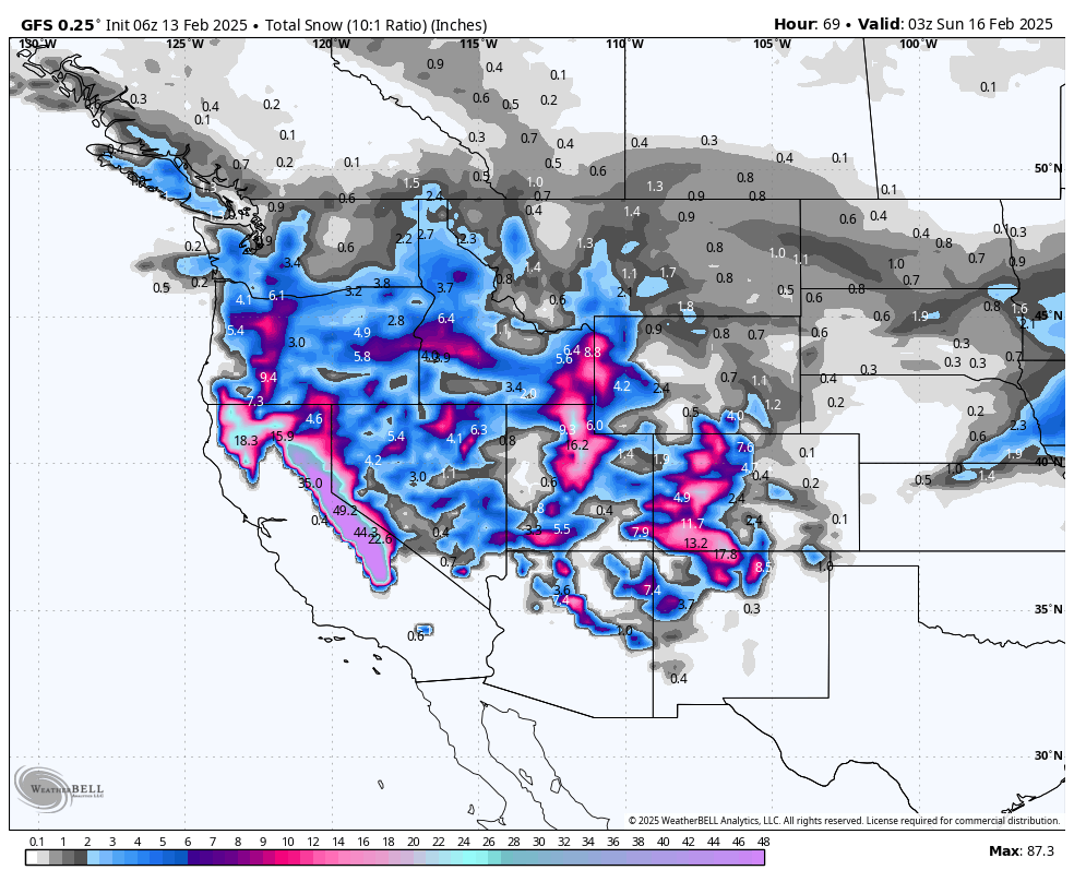
Below: Total snowfall at 10:1 by Friday morning. With colder temperatures, actual amounts will likely exceed these numbers by at least 25% (12:1 or higher snow ratio). This is the first phase of the storm under SW flow. Winds veer West and NW midday on phase 2 of the storm with the cold front. You can see the emphasis in Colorado favoring the southern or western ranges (Even Steamboat can sneak out some snowfall with SW flow).

Below: Look carefully below as snowfall peaks in Colorado's northern and central mountains from Friday morning to Saturday. Snow piles up in the Wasatch and Tetons (Saturday turns).
SW winds are shifting to the West primarily, and some NW components also (Pushing moisture north). With west winds, everyone in Utah stands equal deep chances. This might also favor Teton Pass. NW winds later favor Targhee. Colorado will reap better I-70 benefits from midday Friday to Saturday (Crested Butte, Monarch, Aspen, and I-70 Western Corridor favored).

Below: Winds are strong from the SW Thursday to early Friday in most regions discussed above. By mid-Friday to Saturday, they shift west and then NW. This will favor the central and northern mountains (CO), northern Utah, Tetons, and northern New Mexico (Taos).

Bottom Line Rockies:
Good timing for overnight powder Thursday-Friday morning. 4 corners or Wasatch, likely the deepest. Teton wildcard. The Friday wind shift (W, NW) pushes colder pows into the Wasatch and Tetons from Friday to Saturday. Colorado will benefit from Crested Butte, Aspen, and the I-70 corridor (Western region favored) from midday Friday to Saturday.
Some forecast snow totals through Saturday morning
AZ Snowbowl: 10 inches
Eagle Point: 12 inches
Park City: 22 inches
Alta: 34 inches
Snowbasin: 25 inches
Beaver: 18 inches
JHMR: 15 inches
Targhee: 18 inches
Crested Butte: 15 inches
Telluride: 16 inches
Wolf Creek: 22 inches
Purgatory: 18 inches
Steamboat: 22 inches
Vail: 11 inches
Beaver Creek: 15 inches
Breckenridge: 9 inches
Aspen: 16 inches
Taos: 15 inches
Honorable Mention: Oregon below snags some moisture streaming up from the Sierra on Thursday/Friday. Bachelor and areas south seem a bit favored (12 plus inches of powder).

Extended:
The trend for Sunday this week through mid-next week looks active from the Pacific Northwest. A decent storm from Washington (Sunday) will be dragged into the northern Rockies early next week (Idaho, Wyoming, Montana, and perhaps Utah north/Colorado).
Below: 24-hour snowfall totals from February 16 to February 19. There is a decent chance of some good totals in these regions.

NOTE: Please support Powderchasers with a donation, merchandise purchase(such as a hat or stickers), or sign up for our custom Concierge Powder Forecast Package, where we provide 1:1 phone & email support to get you to the deepest locations possible. When chasing snow, the Concierge gets you the very best intel. Sign up for our free email list so you never miss a powder day. We are also seeking new sponsors and ambassadors who want to submit photos and videos; please reach out for more.
Powderchaser Steve @powderchasersteve on Instagram.


