
Very significant snowfall is likely to overspread the west later this week. The Short term will bring a slider system into Colorado and New Mexico by Tuesday night. Strong moisture and colder temps (Finally) overspread the Sierra Thursday morning and blast the Four Corners by Friday/Saturday (AZ, UT, CO, NM). .
This post is sponsored by Tire Rack. Tire Rack is our official sponsor for our followers. We have trusted The Tire Rack for many years. Tires and wheel sets can be delivered to your home or any Discount Tire Store in the west. Check out the latest winter packages here.
Short Term CO/NM Midweek
The short term looks active from Tuesday night to Wednesday, especially for Colorado. Moisture totals are on the light to moderate end (.37 to perhaps 1/2 inch), however with decent cold air I think the odds of 4-8 inches of snow are relatively high in the areas highlighted below.
Below: Water totals Tuesday night into Wednesday morning for Colorado and northern New Mexico. I think we can see 4-8 inches or more in the highlighted areas. Taos is also a contender. Higher water totals seem to fall along or north of I-70 in Colorado near the Front Range (Upslope) and again further west towards Aspen and Crested Butte.
 The real excitement comes on the Thursday-Saturday period for the west so keep reading.
Late week storm! Get Ready now!
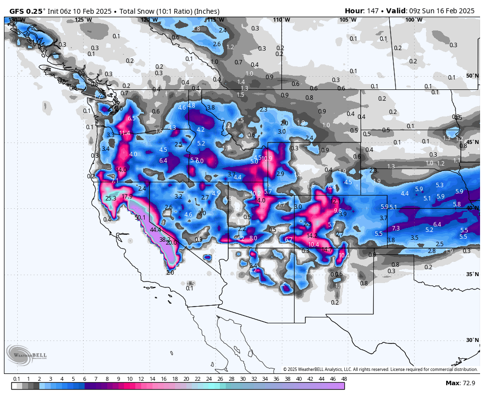
Sierra: Total snowfall through Friday will exceed 2-3 feet in most locations and might approach 30-40 inches for the western Crest. This model (European) favors the southern Sierra, however the American GFS plants 30 plus inches for the entire range. Lake level snow will likely approach 12-18 inches by Friday mid morning as a cold front approaches. Storm ski on Thursday with slightly higher snow levels (6500) and grab better density snow for Friday morning (Wind speeds are more favorable than previous storms). The storm migrates from warm to cold (Ideal situation).

Below: Cold front approaches the Sierra later Thursday evening into Friday. Warmer air moves in Saturday morning. -7C is reasonable for quality powder (5500 snow levels). Lake level snow will be falling by late Thursday. Ride Thursday/Friday and grab leftovers on Saturday (Slight warming trend).

Rockies, Four Corners,
Moisture from the Sierra rapidly moves east over the 4 corners from Thursday PM to Friday PM. Our focus points for the heaviest moisture are highlighted below. Water totals for southern mountains of Utah, Colorado are in the 2 inch range which could equivocate to 20-28 inches of snow. High water totals are also noted extending north into the Wasatch range and even the Tetons (Wildcard being on the northern end of the strongest moisture surge).
Many ski areas in these ranges will grab 15-28 inches of snow with the higher ranges in northern Utah and the Four Corners. Southern and central Oregon is also firing with 5-12 inches of snow (Thursday-Friday).

Below: Snow is filling in the map in the San Juan Range by Friday morning under SW flow. Crested Butte and areas south are favored here.
You can see the snowfall uptick at the end of this loop for the I-70 and northern mountains Friday PM to Saturday. You could chase from southern Colorado Friday morning into the central and northern ranges later Friday to Saturday. New Mexico fires from Friday mid morning to Saturday.

Below: University of Utah ensembles showing several periods of snow for Vail Pass beginning on February 13 (Wednesday) with the first teaser followed by stronger surges later this week (February 15 and again February 18/19). Total weekly snowfall might exceed 20 inches.

Below: Snowbasin in Utah likely to grab 18-25 inches later this week (Thursday night-Saturday).

Below: 30-40 inches possible for Mammoth Mountain by Friday evening this week.

Below: Red Mountain Pass in southern Colorado will be deep by the end of the week (two moisture surges noted with the strongest near February 15).

Below: Snow totals near Beaver Mountain Utah could exceed 20 inches later this week. Check out Beaver Mountain if you want to avoid the crowds!

NOTE: Please support Powderchasers with a donation, Merchandise purchase such as a hat or stickers, or sign up for our custom Concierge Powder Forecast Package, where we provide 1:1 phone and email support to get you to the deepest locations possible.
Powderchaser Steve @powderchasersteve on Instagram.


